
Station XJ LMC - Lemon Cove (Rocky Hill Ranch)
Network: XJ97 - Sierran Paradox
Nearby stations (2 deg radius)
| Station | Name | (Lat, Lon) | Start / End | Elevation |
| LMC | Lemon Cove (Rocky Hill Ranch) | (36.36, -119.03) | 1997-05-29 / 1997-12-31 | 211 m |
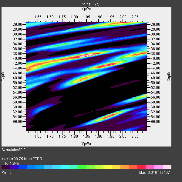
| Crust2 Type: | M9,thick extended crust, 0.5 km seds. |
| Thickness Estimate: | 39 km |
| Thickness StdDev: | 5.8 km |
| Vp/Vs Estimate: | 1.85 |
| Vp/Vs StdDev: | 0.11 |
| Vs Estimate: | 3.41 km/s |
| Poisson's Ratio: | 0.29 |
| Peak Value: | 0.01 |
| Assumed Vp: | 6.291 km/s |
| Ps Weight: | 0.33333334 |
| PpPs Weight: | 0.33333334 |
| PsPs Weight: | 0.33333328 |
| Residual Complexity: | 0.854 |
| Nearby stations H: | +- |
| (2.0 deg) Vp/Vs: | +- |
5 with match > 90% ( 17.857143 %) and 7 with match > 80% ( 25.0 %) out of 28.
Download stack as xyz text file.
Azimuth Distribution of Events:

Prior Results for this Station
| Study | Thickness | Vp/Vs | Vp | Vs | Poissons Ratio | Extra |
| EARS | 39 km | 1.85 | 6.291 km/s | 3.41 km/s | 0.29 | |
| Crust2.0 | 40 km | 1.78 | 6.291 km/s | 3.539 km/s | 0.27 | M9,thick extended crust, 0.5 km seds. |
| Global Maxima | 39 km | 1.85 | 6.291 km/s | 3.41 km/s | 0.29 | amp=0.010719407 |
| Local Maxima 1 | 43 km | 1.93 | 6.291 km/s | 3.26 km/s | 0.32 | amp=0.00957801 |
| Local Maxima 2 | 64 km | 1.94 | 6.291 km/s | 3.243 km/s | 0.32 | amp=0.009123591 |
| Local Maxima 3 | 25 km | 2.00 | 6.291 km/s | 3.142 km/s | 0.33 | amp=0.00897072 |
| Local Maxima 4 | 45 km | 1.61 | 6.291 km/s | 3.92 km/s | 0.18 | amp=0.007738323 |
| Predicted Arrivals for vertical incidence (zero ray parameter) | |
| Ps | 5.20 SECOND |
| PpPs | 17.52 SECOND |
| PsPs/PpSs | 22.73 SECOND |
Events Processed for this Station
Download zip of receiver functions as SAC
Plot maxima for each earthquake.
Events Used in the Stack
(7 events)| Radial Match | Distance | Baz | FERegion | Time | Lat/Lon | Depth | Magnitude |
| 92.06828 | 85.0 deg | 228.836 deg | Kermadec Islands Region | 1997/09/20 16:11:32 GMT | (-28.7, -177.6) | 30 km | 6.1 MB, 7.0 MS, 7.2 UNKNOWN, 6.7 ME |
| 91.79441 | 37.4 deg | 311.228 deg | Fox Islands, Aleutian Islands | 1997/07/20 00:30:20 GMT | (52.6, -167.5) | 14 km | 5.6 MB, 5.9 MS, 6.2 UNKNOWN, 6.2 MW |
| 91.67455 | 83.3 deg | 292.718 deg | Volcano Islands, Japan Region | 1997/07/28 06:46:55 GMT | (22.4, 142.7) | 33 km | 5.7 MB, 5.8 MS, 5.9 UNKNOWN, 5.9 MW |
| 91.129486 | 44.7 deg | 309.265 deg | Andreanof Islands, Aleutian Is. | 1997/06/17 21:03:40 GMT | (51.3, -179.3) | 33 km | 6.4 MB, 6.3 MS, 6.4 UNKNOWN, 6.6 ML |
| 90.6192 | 42.4 deg | 160.062 deg | Central East Pacific Rise | 1997/08/15 07:37:49 GMT | (-4.4, -105.7) | 10 km | 5.3 MB, 5.8 MS, 6.2 UNKNOWN, 6.1 MW |
| 89.56427 | 51.3 deg | 118.727 deg | Colombia | 1997/09/02 12:13:22 GMT | (3.8, -75.7) | 199 km | 6.5 MB, 6.8 UNKNOWN, 6.4 ME |
| 88.99372 | 86.0 deg | 232.874 deg | South Of Fiji Islands | 1997/09/04 04:23:37 GMT | (-26.6, 178.3) | 625 km | 6.3 MB, 6.8 UNKNOWN, 6.5 ME |
Losers
(21 events)| Radial Match | Distance | Baz | FERegion | Time | Lat/Lon | Depth | Magnitude | Reason |
| 78.20867 | 79.8 deg | 139.996 deg | Near Coast Of Central Chile | 1997/07/25 06:47:02 GMT | (-30.5, -71.9) | 33 km | 5.6 MB, 5.5 MS, 6.3 UNKNOWN | |
| 73.15196 | 79.9 deg | 139.999 deg | Near Coast Of Central Chile | 1997/07/27 05:21:29 GMT | (-30.5, -71.9) | 33 km | 5.6 MB, 5.8 MS, 6.3 UNKNOWN, 6.2 MW | |
| 71.800095 | 70.2 deg | 56.626 deg | Azores Islands, Portugal | 1997/06/27 04:39:52 GMT | (38.3, -26.7) | 10 km | 5.6 MB, 5.4 MS, 5.9 UNKNOWN, 5.9 MW | |
| 69.50053 | 77.6 deg | 231.734 deg | Tonga Islands | 1997/09/10 12:57:07 GMT | (-21.3, -174.4) | 10 km | 5.7 MB, 6.1 MS, 6.1 UNKNOWN, 5.9 MW | |
| 66.49409 | 77.2 deg | 131.235 deg | Jujuy Province, Argentina | 1997/07/20 10:14:22 GMT | (-23.0, -66.3) | 256 km | 5.7 MB, 6.1 UNKNOWN, 5.7 ME | |
| 62.24299 | 78.3 deg | 301.009 deg | Southeast Of Honshu, Japan | 1997/09/30 06:27:24 GMT | (32.0, 141.9) | 10 km | 5.5 MB, 6.5 MS, 6.1 UNKNOWN, 6.0 MW | |
| 60.708027 | 81.5 deg | 232.04 deg | South Of Fiji Islands | 1997/06/11 09:29:23 GMT | (-24.0, -177.5) | 164 km | 5.9 UNKNOWN, 5.4 MB, 5.5 MB | |
| 59.6498 | 93.6 deg | 304.666 deg | Southwestern Ryukyu Isl., Japan | 1997/08/13 04:45:04 GMT | (25.0, 125.8) | 55 km | 6.0 MB, 5.6 MS, 6.1 UNKNOWN, 6.1 MW | |
| 59.063023 | 79.0 deg | 139.118 deg | Near Coast Of Central Chile | 1997/07/19 12:22:57 GMT | (-29.3, -71.7) | 26 km | 5.8 MB, 5.5 MS, 5.9 UNKNOWN, 5.8 MW | |
| 58.013626 | 96.0 deg | 306.529 deg | Taiwan Region | 1997/07/15 11:05:31 GMT | (24.7, 122.4) | 103 km | 5.6 MB, 5.6 UNKNOWN, 5.6 MW | |
| 54.44229 | 90.7 deg | 263.121 deg | Solomon Islands | 1997/09/07 12:57:06 GMT | (-6.0, 154.5) | 421 km | 5.6 MB, 5.8 UNKNOWN, 5.8 MW | |
| 53.820213 | 79.4 deg | 234.455 deg | Fiji Islands Region | 1997/08/25 11:59:00 GMT | (-20.8, -177.8) | 394 km | 5.5 UNKNOWN, 5.3 MB | |
| 52.030937 | 79.5 deg | 139.726 deg | Near Coast Of Central Chile | 1997/07/06 09:54:00 GMT | (-30.1, -71.9) | 19 km | 5.8 MB, 6.5 MS, 6.8 UNKNOWN, 6.4 ME | |
| 47.481373 | 69.2 deg | 308.802 deg | Kuril Islands | 1997/07/14 16:09:35 GMT | (43.2, 146.4) | 33 km | 5.9 MB, 5.8 MS, 6.1 UNKNOWN, 5.8 ME | |
| 47.34143 | 84.8 deg | 239.768 deg | Vanuatu Islands Region | 1997/06/24 16:17:09 GMT | (-20.7, 174.2) | 33 km | 5.5 MS, 5.2 MB, 5.9 UNKNOWN, 5.9 MW | |
| 46.107807 | 85.8 deg | 177.098 deg | Southern East Pacific Rise | 1997/06/26 19:21:08 GMT | (-49.7, -114.6) | 10 km | 5.4 MB, 6.0 MS, 6.2 UNKNOWN, 6.1 MW | |
| 42.808136 | 78.0 deg | 237.319 deg | Fiji Islands Region | 1997/06/11 11:53:32 GMT | (-17.8, -178.8) | 573 km | 5.5 UNKNOWN, 4.9 MB | |
| 41.252243 | 82.5 deg | 293.903 deg | Volcano Islands, Japan Region | 1997/07/08 02:24:07 GMT | (23.8, 142.7) | 33 km | 5.8 MB, 5.6 MS, 5.9 UNKNOWN, 5.8 MW | |
| 38.642677 | 34.2 deg | 117.853 deg | Caribbean Sea | 1997/07/06 20:13:37 GMT | (16.2, -87.9) | 33 km | 5.5 MB, 5.5 MS, 6.0 UNKNOWN, 5.9 MW | |
| 29.911243 | 83.7 deg | 308.285 deg | Western Honshu, Japan | 1997/06/25 09:50:12 GMT | (34.4, 131.6) | 10 km | 5.5 MB, 5.6 MS, 5.9 UNKNOWN, 5.8 MW | |
| 27.407005 | 85.3 deg | 233.637 deg | South Of Fiji Islands | 1997/08/26 15:22:09 GMT | (-25.5, 178.3) | 610 km | 5.5 MB, 5.7 UNKNOWN |
