
Station XJ OVY - Onion Valley
Network: XJ97 - Sierran Paradox
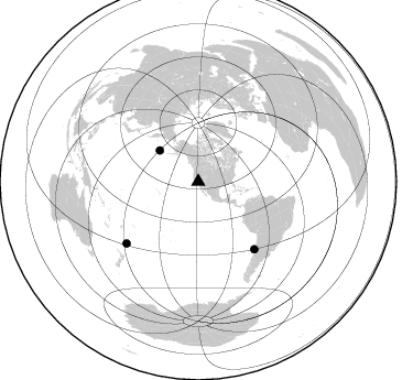
Nearby stations (2 deg radius)
| Station | Name | (Lat, Lon) | Start / End | Elevation |
| OVY | Onion Valley | (36.78, -118.33) | 1997-06-04 / 1997-12-31 | 2704 m |
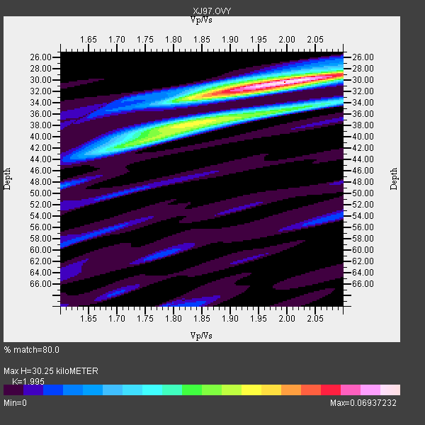
| Crust2 Type: | M9,thick extended crust, 0.5 km seds. |
| Thickness Estimate: | 30 km |
| Thickness StdDev: | 3.3 km |
| Vp/Vs Estimate: | 2.00 |
| Vp/Vs StdDev: | 0.08 |
| Vs Estimate: | 3.154 km/s |
| Poisson's Ratio: | 0.33 |
| Peak Value: | 0.07 |
| Assumed Vp: | 6.291 km/s |
| Ps Weight: | 0.33333334 |
| PpPs Weight: | 0.33333334 |
| PsPs Weight: | 0.33333328 |
| Residual Complexity: | 0.597 |
| Nearby stations H: | +- |
| (2.0 deg) Vp/Vs: | +- |
1 with match > 90% ( 8.333333 %) and 3 with match > 80% ( 25.0 %) out of 12.
Download stack as xyz text file.
Azimuth Distribution of Events:
Prior Results for this Station
| Study | Thickness | Vp/Vs | Vp | Vs | Poissons Ratio | Extra |
| EARS | 30 km | 2.00 | 6.291 km/s | 3.154 km/s | 0.33 | |
| Crust2.0 | 40 km | 1.78 | 6.291 km/s | 3.539 km/s | 0.27 | M9,thick extended crust, 0.5 km seds. |
| Global Maxima | 30 km | 2.00 | 6.291 km/s | 3.154 km/s | 0.33 | amp=0.06937232 |
| Local Maxima 1 | 38 km | 1.85 | 6.291 km/s | 3.41 km/s | 0.29 | amp=0.038394574 |
| Local Maxima 2 | 33 km | 1.85 | 6.291 km/s | 3.41 km/s | 0.29 | amp=0.02955374 |
| Local Maxima 3 | 41 km | 1.73 | 6.291 km/s | 3.642 km/s | 0.25 | amp=0.028128607 |
| Local Maxima 4 | 35 km | 2.02 | 6.291 km/s | 3.114 km/s | 0.34 | amp=0.026229829 |
| Predicted Arrivals for vertical incidence (zero ray parameter) | |
| Ps | 4.78 SECOND |
| PpPs | 14.40 SECOND |
| PsPs/PpSs | 19.18 SECOND |
Events Processed for this Station
Download zip of receiver functions as SAC
Plot maxima for each earthquake.
Events Used in the Stack
(3 events)| Radial Match | Distance | Baz | FERegion | Time | Lat/Lon | Depth | Magnitude |
| 93.85145 | 44.9 deg | 308.995 deg | Andreanof Islands, Aleutian Is. | 1997/06/17 21:03:40 GMT | (51.3, -179.3) | 33 km | 6.4 MB, 6.3 MS, 6.4 UNKNOWN, 6.6 ML |
| 89.89944 | 85.7 deg | 229.256 deg | Kermadec Islands Region | 1997/09/20 16:11:32 GMT | (-28.7, -177.6) | 30 km | 6.1 MB, 7.0 MS, 7.2 UNKNOWN, 6.7 ME |
| 87.71402 | 79.5 deg | 140.272 deg | Near Coast Of Central Chile | 1997/07/06 09:54:00 GMT | (-30.1, -71.9) | 19 km | 5.8 MB, 6.5 MS, 6.8 UNKNOWN, 6.4 ME |
Losers
(9 events)| Radial Match | Distance | Baz | FERegion | Time | Lat/Lon | Depth | Magnitude | Reason |
| 69.23063 | 69.3 deg | 308.96 deg | Kuril Islands | 1997/07/14 16:09:35 GMT | (43.2, 146.4) | 33 km | 5.9 MB, 5.8 MS, 6.1 UNKNOWN, 5.8 ME | |
| 67.08756 | 77.1 deg | 131.808 deg | Jujuy Province, Argentina | 1997/07/20 10:14:22 GMT | (-23.0, -66.3) | 256 km | 5.7 MB, 6.1 UNKNOWN, 5.7 ME | |
| 64.38371 | 82.9 deg | 294.24 deg | Volcano Islands, Japan Region | 1997/07/08 02:24:07 GMT | (23.8, 142.7) | 33 km | 5.8 MB, 5.6 MS, 5.9 UNKNOWN, 5.8 MW | |
| 63.576385 | 86.7 deg | 233.29 deg | South Of Fiji Islands | 1997/09/04 04:23:37 GMT | (-26.6, 178.3) | 625 km | 6.3 MB, 6.8 UNKNOWN, 6.5 ME | |
| 62.790073 | 79.0 deg | 139.67 deg | Near Coast Of Central Chile | 1997/07/19 12:22:57 GMT | (-29.3, -71.7) | 26 km | 5.8 MB, 5.5 MS, 5.9 UNKNOWN, 5.8 MW | |
| 61.65616 | 42.6 deg | 161.211 deg | Central East Pacific Rise | 1997/08/15 07:37:49 GMT | (-4.4, -105.7) | 10 km | 5.3 MB, 5.8 MS, 6.2 UNKNOWN, 6.1 MW | |
| 56.627567 | 82.2 deg | 232.457 deg | South Of Fiji Islands | 1997/06/11 09:29:23 GMT | (-24.0, -177.5) | 164 km | 5.9 UNKNOWN, 5.4 MB, 5.5 MB | |
| 51.645866 | 88.4 deg | 227.499 deg | Kermadec Islands Region | 1997/10/07 13:15:53 GMT | (-31.8, -178.3) | 33 km | 5.5 MB, 5.6 MS | |
| 41.08235 | 91.3 deg | 263.543 deg | Solomon Islands | 1997/09/07 12:57:06 GMT | (-6.0, 154.5) | 421 km | 5.6 MB, 5.8 UNKNOWN, 5.8 MW |
