
Station XJ SFK - South Fork Kaweah River
Network: XJ97 - Sierran Paradox
Nearby stations (2 deg radius)
| Station | Name | (Lat, Lon) | Start / End | Elevation |
| SFK | South Fork Kaweah River | (36.37, -118.81) | 1997-06-24 / 1997-12-31 | 812 m |
| Crust2 Type: | M9,thick extended crust, 0.5 km seds. |
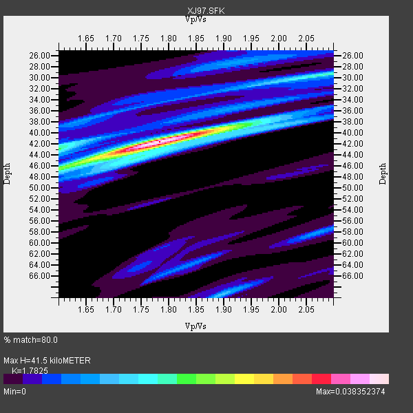
| Thickness Estimate: | 42 km |
| Thickness StdDev: | 2.8 km |
| Vp/Vs Estimate: | 1.78 |
| Vp/Vs StdDev: | 0.07 |
| Vs Estimate: | 3.529 km/s |
| Poisson's Ratio: | 0.27 |
| Peak Value: | 0.04 |
| Assumed Vp: | 6.291 km/s |
| Ps Weight: | 0.33333334 |
| PpPs Weight: | 0.33333334 |
| PsPs Weight: | 0.33333328 |
| Residual Complexity: | 0.548 |
| Nearby stations H: | +- |
| (2.0 deg) Vp/Vs: | +- |
1 with match > 90% ( 4.347826 %) and 3 with match > 80% ( 13.043478 %) out of 23.
Download stack as xyz text file.
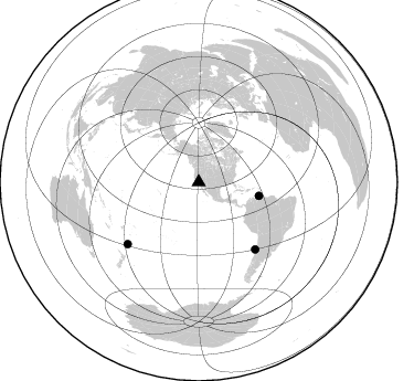
Azimuth Distribution of Events:
Prior Results for this Station
| Study | Thickness | Vp/Vs | Vp | Vs | Poissons Ratio | Extra |
| EARS | 42 km | 1.78 | 6.291 km/s | 3.529 km/s | 0.27 | |
| Crust2.0 | 40 km | 1.78 | 6.291 km/s | 3.539 km/s | 0.27 | M9,thick extended crust, 0.5 km seds. |
| Global Maxima | 42 km | 1.78 | 6.291 km/s | 3.529 km/s | 0.27 | amp=0.038352374 |
| Local Maxima 1 | 46 km | 1.61 | 6.291 km/s | 3.92 km/s | 0.18 | amp=0.017941087 |
| Local Maxima 2 | 29 km | 2.09 | 6.291 km/s | 3.01 km/s | 0.35 | amp=0.015811946 |
| Local Maxima 3 | 43 km | 1.60 | 6.291 km/s | 3.932 km/s | 0.18 | amp=0.015681317 |
| Local Maxima 4 | 69 km | 1.89 | 6.291 km/s | 3.32 km/s | 0.31 | amp=0.0105572855 |
| Predicted Arrivals for vertical incidence (zero ray parameter) | |
| Ps | 5.16 SECOND |
| PpPs | 18.35 SECOND |
| PsPs/PpSs | 23.52 SECOND |
Events Processed for this Station
Download zip of receiver functions as SAC
Plot maxima for each earthquake.
Events Used in the Stack
(3 events)| Radial Match | Distance | Baz | FERegion | Time | Lat/Lon | Depth | Magnitude |
| 97.39622 | 56.0 deg | 102.732 deg | Near Coast Of Venezuela | 1997/07/09 19:24:13 GMT | (10.6, -63.5) | 20 km | 6.2 MB, 6.8 MS, 7.0 UNKNOWN, 6.6 ME |
| 88.472435 | 85.1 deg | 228.972 deg | Kermadec Islands Region | 1997/09/20 16:11:32 GMT | (-28.7, -177.6) | 30 km | 6.1 MB, 7.0 MS, 7.2 UNKNOWN, 6.7 ME |
| 86.07033 | 79.4 deg | 139.878 deg | Near Coast Of Central Chile | 1997/07/06 09:54:00 GMT | (-30.1, -71.9) | 19 km | 5.8 MB, 6.5 MS, 6.8 UNKNOWN, 6.4 ME |
Losers
(20 events)| Radial Match | Distance | Baz | FERegion | Time | Lat/Lon | Depth | Magnitude | Reason |
| 82.14428 | 83.5 deg | 292.836 deg | Volcano Islands, Japan Region | 1997/07/28 06:46:55 GMT | (22.4, 142.7) | 33 km | 5.7 MB, 5.8 MS, 5.9 UNKNOWN, 5.9 MW | |
| 79.62016 | 70.1 deg | 56.721 deg | Azores Islands, Portugal | 1997/06/27 04:39:52 GMT | (38.3, -26.7) | 10 km | 5.6 MB, 5.4 MS, 5.9 UNKNOWN, 5.9 MW | |
| 76.004395 | 85.4 deg | 233.772 deg | South Of Fiji Islands | 1997/08/26 15:22:09 GMT | (-25.5, 178.3) | 610 km | 5.5 MB, 5.7 UNKNOWN | |
| 72.726 | 78.9 deg | 139.271 deg | Near Coast Of Central Chile | 1997/07/19 12:22:57 GMT | (-29.3, -71.7) | 26 km | 5.8 MB, 5.5 MS, 5.9 UNKNOWN, 5.8 MW | |
| 64.59258 | 82.7 deg | 294.019 deg | Volcano Islands, Japan Region | 1997/07/08 02:24:07 GMT | (23.8, 142.7) | 33 km | 5.8 MB, 5.6 MS, 5.9 UNKNOWN, 5.8 MW | |
| 62.65782 | 34.0 deg | 118.11 deg | Caribbean Sea | 1997/07/06 20:13:37 GMT | (16.2, -87.9) | 33 km | 5.5 MB, 5.5 MS, 6.0 UNKNOWN, 5.9 MW | |
| 59.034824 | 51.1 deg | 118.926 deg | Colombia | 1997/09/02 12:13:22 GMT | (3.8, -75.7) | 199 km | 6.5 MB, 6.8 UNKNOWN, 6.4 ME | |
| 52.000153 | 86.1 deg | 233.008 deg | South Of Fiji Islands | 1997/09/04 04:23:37 GMT | (-26.6, 178.3) | 625 km | 6.3 MB, 6.8 UNKNOWN, 6.5 ME | |
| 50.93517 | 37.5 deg | 311.198 deg | Fox Islands, Aleutian Islands | 1997/07/20 00:30:20 GMT | (52.6, -167.5) | 14 km | 5.6 MB, 5.9 MS, 6.2 UNKNOWN, 6.2 MW | |
| 46.161934 | 79.6 deg | 234.599 deg | Fiji Islands Region | 1997/08/25 11:59:00 GMT | (-20.8, -177.8) | 394 km | 5.5 UNKNOWN, 5.3 MB | |
| 43.3112 | 83.8 deg | 308.399 deg | Western Honshu, Japan | 1997/06/25 09:50:12 GMT | (34.4, 131.6) | 10 km | 5.5 MB, 5.6 MS, 5.9 UNKNOWN, 5.8 MW | |
| 40.3841 | 90.9 deg | 263.248 deg | Solomon Islands | 1997/09/07 12:57:06 GMT | (-6.0, 154.5) | 421 km | 5.6 MB, 5.8 UNKNOWN, 5.8 MW | |
| 39.96701 | 96.2 deg | 306.667 deg | Taiwan Region | 1997/07/15 11:05:31 GMT | (24.7, 122.4) | 103 km | 5.6 MB, 5.6 UNKNOWN, 5.6 MW | |
| 39.07256 | 74.2 deg | 237.059 deg | Tonga Islands | 1997/08/29 06:54:00 GMT | (-15.2, -175.6) | 33 km | 5.6 MB, 6.4 MS, 6.5 UNKNOWN, 6.4 MW | |
| 37.46639 | 79.8 deg | 140.15 deg | Near Coast Of Central Chile | 1997/07/27 05:21:29 GMT | (-30.5, -71.9) | 33 km | 5.6 MB, 5.8 MS, 6.3 UNKNOWN, 6.2 MW | |
| 36.846886 | 42.3 deg | 160.37 deg | Central East Pacific Rise | 1997/08/15 07:37:49 GMT | (-4.4, -105.7) | 10 km | 5.3 MB, 5.8 MS, 6.2 UNKNOWN, 6.1 MW | |
| 36.60313 | 93.8 deg | 304.799 deg | Southwestern Ryukyu Isl., Japan | 1997/08/13 04:45:04 GMT | (25.0, 125.8) | 55 km | 6.0 MB, 5.6 MS, 6.1 UNKNOWN, 6.1 MW | |
| 35.12426 | 77.1 deg | 131.389 deg | Jujuy Province, Argentina | 1997/07/20 10:14:22 GMT | (-23.0, -66.3) | 256 km | 5.7 MB, 6.1 UNKNOWN, 5.7 ME | |
| 31.842268 | 77.8 deg | 231.883 deg | Tonga Islands | 1997/09/10 12:57:07 GMT | (-21.3, -174.4) | 10 km | 5.7 MB, 6.1 MS, 6.1 UNKNOWN, 5.9 MW | |
| 22.453585 | 69.3 deg | 308.885 deg | Kuril Islands | 1997/07/14 16:09:35 GMT | (43.2, 146.4) | 33 km | 5.9 MB, 5.8 MS, 6.1 UNKNOWN, 5.8 ME |
