
Station XJ SMD - Simpson Meadow
Network: XJ97 - Sierran Paradox
Nearby stations (2 deg radius)

| Station | Name | (Lat, Lon) | Start / End | Elevation |
| SMD | Simpson Meadow | (36.97, -118.63) | 1997-06-19 / 1997-12-31 | 1807 m |
| Crust2 Type: | M9,thick extended crust, 0.5 km seds. |
| Thickness Estimate: | 45 km |
| Thickness StdDev: | 5.9 km |
| Vp/Vs Estimate: | 1.77 |
| Vp/Vs StdDev: | 0.09 |
| Vs Estimate: | 3.549 km/s |
| Poisson's Ratio: | 0.27 |
| Peak Value: | 0.01 |
| Assumed Vp: | 6.291 km/s |
| Ps Weight: | 0.33333334 |
| PpPs Weight: | 0.33333334 |
| PsPs Weight: | 0.33333328 |
| Residual Complexity: | 0.656 |
| Nearby stations H: | +- |
| (2.0 deg) Vp/Vs: | +- |
4 with match > 90% ( 21.052631 %) and 11 with match > 80% ( 57.894737 %) out of 19.
Download stack as xyz text file.
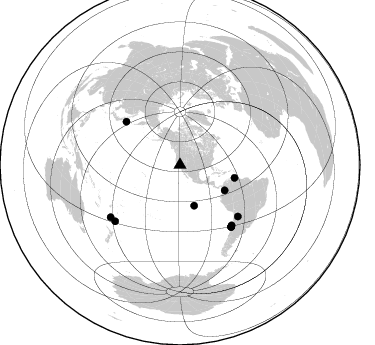
Azimuth Distribution of Events:
Prior Results for this Station
| Study | Thickness | Vp/Vs | Vp | Vs | Poissons Ratio | Extra |
| EARS | 45 km | 1.77 | 6.291 km/s | 3.549 km/s | 0.27 | |
| Crust2.0 | 40 km | 1.78 | 6.291 km/s | 3.539 km/s | 0.27 | M9,thick extended crust, 0.5 km seds. |
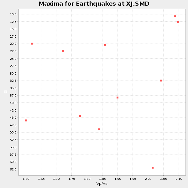
| Global Maxima | 45 km | 1.77 | 6.291 km/s | 3.549 km/s | 0.27 | amp=0.010083731 |
| Local Maxima 1 | 38 km | 1.91 | 6.291 km/s | 3.298 km/s | 0.31 | amp=0.008094062 |
| Local Maxima 2 | 47 km | 1.72 | 6.291 km/s | 3.652 km/s | 0.25 | amp=0.005357675 |
| Local Maxima 3 | 37 km | 1.74 | 6.291 km/s | 3.626 km/s | 0.25 | amp=0.0044030775 |
| Local Maxima 4 | 27 km | 1.63 | 6.291 km/s | 3.848 km/s | 0.20 | amp=0.004222268 |
| Predicted Arrivals for vertical incidence (zero ray parameter) | |
| Ps | 5.49 SECOND |
| PpPs | 19.72 SECOND |
| PsPs/PpSs | 25.22 SECOND |
Events Processed for this Station
Download zip of receiver functions as SAC
Plot maxima for each earthquake.
Events Used in the Stack
(11 events)| Radial Match | Distance | Baz | FERegion | Time | Lat/Lon | Depth | Magnitude |
| 94.82977 | 56.0 deg | 103.261 deg | Near Coast Of Venezuela | 1997/07/09 19:24:13 GMT | (10.6, -63.5) | 20 km | 6.2 MB, 6.8 MS, 7.0 UNKNOWN, 6.6 ME |
| 94.5084 | 79.8 deg | 140.08 deg | Near Coast Of Central Chile | 1997/07/06 09:54:00 GMT | (-30.1, -71.9) | 19 km | 5.8 MB, 6.5 MS, 6.8 UNKNOWN, 6.4 ME |
| 92.18284 | 42.9 deg | 160.85 deg | Central East Pacific Rise | 1997/08/15 07:37:49 GMT | (-4.4, -105.7) | 10 km | 5.3 MB, 5.8 MS, 6.2 UNKNOWN, 6.1 MW |
| 91.23961 | 85.6 deg | 229.052 deg | Kermadec Islands Region | 1997/09/20 16:11:32 GMT | (-28.7, -177.6) | 30 km | 6.1 MB, 7.0 MS, 7.2 UNKNOWN, 6.7 ME |
| 89.28249 | 69.0 deg | 308.78 deg | Kuril Islands | 1997/07/14 16:09:35 GMT | (43.2, 146.4) | 33 km | 5.9 MB, 5.8 MS, 6.1 UNKNOWN, 5.8 ME |
| 89.09804 | 51.3 deg | 119.518 deg | Colombia | 1997/09/02 12:13:22 GMT | (3.8, -75.7) | 199 km | 6.5 MB, 6.8 UNKNOWN, 6.4 ME |
| 87.75195 | 80.2 deg | 140.348 deg | Near Coast Of Central Chile | 1997/07/27 05:21:29 GMT | (-30.5, -71.9) | 33 km | 5.6 MB, 5.8 MS, 6.3 UNKNOWN, 6.2 MW |
| 83.50823 | 86.6 deg | 233.092 deg | South Of Fiji Islands | 1997/09/04 04:23:37 GMT | (-26.6, 178.3) | 625 km | 6.3 MB, 6.8 UNKNOWN, 6.5 ME |
| 81.710686 | 80.1 deg | 140.346 deg | Near Coast Of Central Chile | 1997/07/25 06:47:02 GMT | (-30.5, -71.9) | 33 km | 5.6 MB, 5.5 MS, 6.3 UNKNOWN |
| 81.58641 | 77.4 deg | 131.624 deg | Jujuy Province, Argentina | 1997/07/20 10:14:22 GMT | (-23.0, -66.3) | 256 km | 5.7 MB, 6.1 UNKNOWN, 5.7 ME |
| 80.76449 | 79.3 deg | 139.478 deg | Near Coast Of Central Chile | 1997/07/19 12:22:57 GMT | (-29.3, -71.7) | 26 km | 5.8 MB, 5.5 MS, 5.9 UNKNOWN, 5.8 MW |
Losers
(8 events)| Radial Match | Distance | Baz | FERegion | Time | Lat/Lon | Depth | Magnitude | Reason |
| 89.78519 | 74.4 deg | 236.885 deg | Tonga Islands | 1997/08/04 18:53:58 GMT | (-15.2, -175.3) | 33 km | 5.5 MB, 6.0 MS, 6.1 UNKNOWN, 6.0 MW | |
| 78.37891 | 80.0 deg | 140.273 deg | Near Coast Of Central Chile | 1997/07/21 23:19:39 GMT | (-30.3, -71.9) | 33 km | 5.2 MB, 5.5 MS, 6.1 UNKNOWN | |
| 64.25159 | 85.9 deg | 233.851 deg | South Of Fiji Islands | 1997/08/26 15:22:09 GMT | (-25.5, 178.3) | 610 km | 5.5 MB, 5.7 UNKNOWN | |
| 63.102592 | 91.1 deg | 263.367 deg | Solomon Islands | 1997/09/07 12:57:06 GMT | (-6.0, 154.5) | 421 km | 5.6 MB, 5.8 UNKNOWN, 5.8 MW | |
| 61.462307 | 82.6 deg | 294.049 deg | Volcano Islands, Japan Region | 1997/07/08 02:24:07 GMT | (23.8, 142.7) | 33 km | 5.8 MB, 5.6 MS, 5.9 UNKNOWN, 5.8 MW | |
| 57.863262 | 95.9 deg | 306.837 deg | Taiwan Region | 1997/07/15 11:05:31 GMT | (24.7, 122.4) | 103 km | 5.6 MB, 5.6 UNKNOWN, 5.6 MW | |
| 54.831745 | 80.1 deg | 234.635 deg | Fiji Islands Region | 1997/08/25 11:59:00 GMT | (-20.8, -177.8) | 394 km | 5.5 UNKNOWN, 5.3 MB | |
| 47.016075 | 75.7 deg | 132.809 deg | Northern Chile | 1997/09/28 23:13:13 GMT | (-22.4, -68.4) | 107 km | 5.7 MB, 5.6 UNKNOWN, 5.6 MW |
