
Station XJ TWR2 - Tower Rock 2
Network: XJ97 - Sierran Paradox
Nearby stations (2 deg radius)
| Station | Name | (Lat, Lon) | Start / End | Elevation |
| TWR2 | Tower Rock 2 | (36.35, -118.41) | 1997-06-22 / 1997-12-31 | 1946 m |
| Crust2 Type: | M9,thick extended crust, 0.5 km seds. |
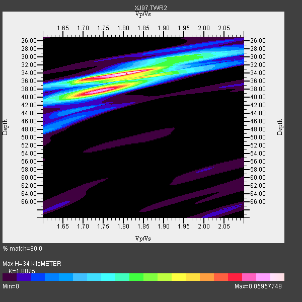
| Thickness Estimate: | 34 km |
| Thickness StdDev: | 2.0 km |
| Vp/Vs Estimate: | 1.81 |
| Vp/Vs StdDev: | 0.06 |
| Vs Estimate: | 3.481 km/s |
| Poisson's Ratio: | 0.28 |
| Peak Value: | 0.06 |
| Assumed Vp: | 6.291 km/s |
| Ps Weight: | 0.33333334 |
| PpPs Weight: | 0.33333334 |
| PsPs Weight: | 0.33333328 |
| Residual Complexity: | 0.583 |
| Nearby stations H: | +- |
| (2.0 deg) Vp/Vs: | +- |
1 with match > 90% ( 6.6666665 %) and 3 with match > 80% ( 20.0 %) out of 15.
Download stack as xyz text file.
Azimuth Distribution of Events:
Prior Results for this Station
| Study | Thickness | Vp/Vs | Vp | Vs | Poissons Ratio | Extra |
| EARS | 34 km | 1.81 | 6.291 km/s | 3.481 km/s | 0.28 | |
| Crust2.0 | 40 km | 1.78 | 6.291 km/s | 3.539 km/s | 0.27 | M9,thick extended crust, 0.5 km seds. |
| Global Maxima | 34 km | 1.81 | 6.291 km/s | 3.481 km/s | 0.28 | amp=0.05957749 |
| Local Maxima 1 | 38 km | 1.75 | 6.291 km/s | 3.6 km/s | 0.26 | amp=0.04337425 |
| Local Maxima 2 | 35 km | 1.87 | 6.291 km/s | 3.369 km/s | 0.30 | amp=0.028638903 |
| Local Maxima 3 | 36 km | 1.70 | 6.291 km/s | 3.706 km/s | 0.23 | amp=0.017972445 |
| Local Maxima 4 | 30 km | 1.96 | 6.291 km/s | 3.214 km/s | 0.32 | amp=0.017778633 |
| Predicted Arrivals for vertical incidence (zero ray parameter) | |
| Ps | 4.36 SECOND |
| PpPs | 15.17 SECOND |
| PsPs/PpSs | 19.54 SECOND |
Events Processed for this Station
Download zip of receiver functions as SAC
Plot maxima for each earthquake.
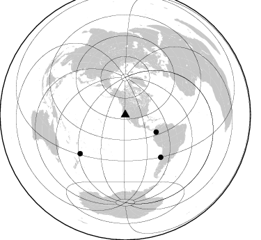
Events Used in the Stack
(3 events)| Radial Match | Distance | Baz | FERegion | Time | Lat/Lon | Depth | Magnitude |
| 92.8606 | 85.3 deg | 229.231 deg | Kermadec Islands Region | 1997/09/20 16:11:32 GMT | (-28.7, -177.6) | 30 km | 6.1 MB, 7.0 MS, 7.2 UNKNOWN, 6.7 ME |
| 87.3973 | 79.2 deg | 140.164 deg | Near Coast Of Central Chile | 1997/07/06 09:54:00 GMT | (-30.1, -71.9) | 19 km | 5.8 MB, 6.5 MS, 6.8 UNKNOWN, 6.4 ME |
| 84.89794 | 50.8 deg | 119.286 deg | Colombia | 1997/09/02 12:13:22 GMT | (3.8, -75.7) | 199 km | 6.5 MB, 6.8 UNKNOWN, 6.4 ME |
Losers
(12 events)| Radial Match | Distance | Baz | FERegion | Time | Lat/Lon | Depth | Magnitude | Reason |
| 79.961945 | 37.8 deg | 311.172 deg | Fox Islands, Aleutian Islands | 1997/07/20 00:30:20 GMT | (52.6, -167.5) | 14 km | 5.6 MB, 5.9 MS, 6.2 UNKNOWN, 6.2 MW | |
| 79.549385 | 85.7 deg | 234.028 deg | South Of Fiji Islands | 1997/08/26 15:22:09 GMT | (-25.5, 178.3) | 610 km | 5.5 MB, 5.7 UNKNOWN | |
| 74.243576 | 86.4 deg | 233.261 deg | South Of Fiji Islands | 1997/09/04 04:23:37 GMT | (-26.6, 178.3) | 625 km | 6.3 MB, 6.8 UNKNOWN, 6.5 ME | |
| 72.994156 | 85.6 deg | 249.773 deg | Vanuatu Islands | 1997/08/17 20:11:10 GMT | (-13.6, 167.4) | 26 km | 5.4 MB, 6.1 MS, 6.1 UNKNOWN, 6.0 MW | |
| 69.93993 | 69.6 deg | 309.051 deg | Kuril Islands | 1997/07/14 16:09:35 GMT | (43.2, 146.4) | 33 km | 5.9 MB, 5.8 MS, 6.1 UNKNOWN, 5.8 ME | |
| 69.745125 | 78.7 deg | 139.559 deg | Near Coast Of Central Chile | 1997/07/19 12:22:57 GMT | (-29.3, -71.7) | 26 km | 5.8 MB, 5.5 MS, 5.9 UNKNOWN, 5.8 MW | |
| 69.50992 | 78.8 deg | 301.324 deg | Southeast Of Honshu, Japan | 1997/09/30 06:27:24 GMT | (32.0, 141.9) | 10 km | 5.5 MB, 6.5 MS, 6.1 UNKNOWN, 6.0 MW | |
| 65.25622 | 33.7 deg | 118.564 deg | Caribbean Sea | 1997/07/06 20:13:37 GMT | (16.2, -87.9) | 33 km | 5.5 MB, 5.5 MS, 6.0 UNKNOWN, 5.9 MW | |
| 64.36619 | 83.0 deg | 294.244 deg | Volcano Islands, Japan Region | 1997/07/08 02:24:07 GMT | (23.8, 142.7) | 33 km | 5.8 MB, 5.6 MS, 5.9 UNKNOWN, 5.8 MW | |
| 58.053333 | 85.2 deg | 240.157 deg | Vanuatu Islands Region | 1997/06/24 16:17:09 GMT | (-20.7, 174.2) | 33 km | 5.5 MS, 5.2 MB, 5.9 UNKNOWN, 5.9 MW | |
| 54.57627 | 76.8 deg | 131.677 deg | Jujuy Province, Argentina | 1997/07/20 10:14:22 GMT | (-23.0, -66.3) | 256 km | 5.7 MB, 6.1 UNKNOWN, 5.7 ME | |
| 54.491123 | 88.0 deg | 227.461 deg | Kermadec Islands Region | 1997/10/07 13:15:53 GMT | (-31.8, -178.3) | 33 km | 5.5 MB, 5.6 MS |
