
Station XK BENH - Beinn Eighe Nature Reserve
Network: XK01 - Reflections under the Scottish Highlands
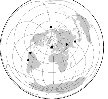
Nearby stations (2 deg radius)
| Station | Name | (Lat, Lon) | Start / End | Elevation |
| BENH | Beinn Eighe Nature Reserve | (57.61, -5.31) | 2001-07-06 / 2003-12-31 | 0.1 km |
| Crust2 Type: | M5,extended crust, 0.5 km seds. |
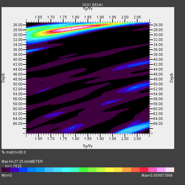
| Thickness Estimate: | 27 km |
| Thickness StdDev: | 0.7 km |
| Vp/Vs Estimate: | 1.78 |
| Vp/Vs StdDev: | 0.08 |
| Vs Estimate: | 3.521 km/s |
| Poisson's Ratio: | 0.27 |
| Peak Value: | 0.06 |
| Assumed Vp: | 6.276 km/s |
| Ps Weight: | 0.33333334 |
| PpPs Weight: | 0.33333334 |
| PsPs Weight: | 0.33333328 |
| Residual Complexity: | 0.412 |
| Nearby stations H: | +- |
| (2.0 deg) Vp/Vs: | +- |
3 with match > 90% ( 50.0 %) and 6 with match > 80% ( 100.0 %) out of 6.
Download stack as xyz text file.
Azimuth Distribution of Events:
Prior Results for this Station
| Study | Thickness | Vp/Vs | Vp | Vs | Poissons Ratio | Extra |
| EARS | 27 km | 1.78 | 6.276 km/s | 3.521 km/s | 0.27 | |
| Crust2.0 | 31 km | 1.78 | 6.276 km/s | 3.529 km/s | 0.27 | M5,extended crust, 0.5 km seds. |
| Global Maxima | 27 km | 1.78 | 6.276 km/s | 3.521 km/s | 0.27 | amp=0.059973966 |
| Local Maxima 1 | 28 km | 1.60 | 6.276 km/s | 3.916 km/s | 0.18 | amp=0.029852016 |
| Local Maxima 2 | 30 km | 1.70 | 6.276 km/s | 3.697 km/s | 0.23 | amp=0.025529621 |
| Local Maxima 3 | 68 km | 2.01 | 6.276 km/s | 3.13 km/s | 0.33 | amp=0.016744336 |
| Local Maxima 4 | 25 km | 1.99 | 6.276 km/s | 3.15 km/s | 0.33 | amp=0.012681178 |
| Predicted Arrivals for vertical incidence (zero ray parameter) | |
| Ps | 3.40 SECOND |
| PpPs | 12.08 SECOND |
| PsPs/PpSs | 15.48 SECOND |
Events Processed for this Station
Download zip of receiver functions as SAC
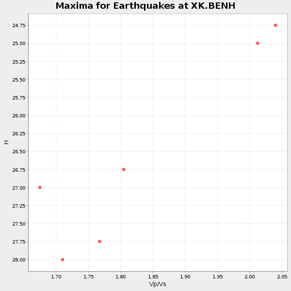
Plot maxima for each earthquake.
Events Used in the Stack
(6 events)| Radial Match | Distance | Baz | FERegion | Time | Lat/Lon | Depth | Magnitude |
| 93.51685 | 92.9 deg | 241.379 deg | Near Coast Of Peru | 2001/07/07 09:38:43 GMT | (-17.5, -72.1) | 33 km | 6.6 MB, 7.3 MS, 7.6 MW, 7.5 ME |
| 93.20997 | 52.8 deg | 79.077 deg | Hindu Kush Region, Afghanistan | 2002/03/03 12:08:07 GMT | (36.4, 70.4) | 209 km | 6.3 MB |
| 91.34684 | 52.7 deg | 78.983 deg | Hindu Kush Region, Afghanistan | 2002/03/03 12:08:19 GMT | (36.5, 70.5) | 226 km | 6.6 MB, 7.4 MW, 7.3 MW |
| 87.90354 | 71.4 deg | 357.823 deg | Rat Islands, Aleutian Islands | 2003/03/17 16:36:17 GMT | (51.3, 178.0) | 33 km | 5.9 MB, 6.7 MS, 7.0 MW, 7.0 MW |
| 85.41143 | 76.4 deg | 255.562 deg | Colombia | 2001/09/22 03:23:38 GMT | (3.9, -76.0) | 179 km | 6.0 MB, 6.0 MW, 6.0 MW |
| 85.258835 | 83.5 deg | 76.006 deg | Andaman Islands, India Region | 2002/09/13 22:28:29 GMT | (13.0, 93.1) | 21 km | 6.2 MB, 6.7 MS, 6.5 MW, 6.5 MW |
Losers
(0 events)| Radial Match | Distance | Baz | FERegion | Time | Lat/Lon | Depth | Magnitude | Reason |
