
Station XK BOHN - Bohenie
Network: XK01 - Reflections under the Scottish Highlands
Nearby stations (2 deg radius)
| Station | Name | (Lat, Lon) | Start / End | Elevation |
| BOHN | Bohenie | (56.91, -4.80) | 2001-07-10 / 2003-12-31 | 0.2 km |
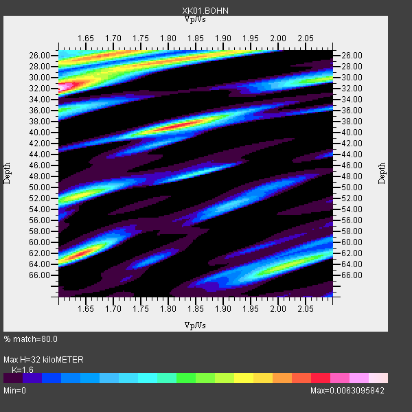
| Crust2 Type: | M5,extended crust, 0.5 km seds. |
| Thickness Estimate: | 32 km |
| Thickness StdDev: | 14 km |
| Vp/Vs Estimate: | 1.60 |
| Vp/Vs StdDev: | 0.16 |
| Vs Estimate: | 3.922 km/s |
| Poisson's Ratio: | 0.18 |
| Peak Value: | 0.01 |
| Assumed Vp: | 6.276 km/s |
| Ps Weight: | 0.33333334 |
| PpPs Weight: | 0.33333334 |
| PsPs Weight: | 0.33333328 |
| Residual Complexity: | 0.900 |
| Nearby stations H: | +- |
| (2.0 deg) Vp/Vs: | +- |
4 with match > 90% ( 57.142857 %) and 7 with match > 80% ( 100.0 %) out of 7.
Download stack as xyz text file.
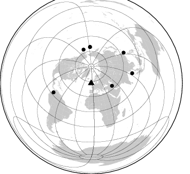
Azimuth Distribution of Events:
Prior Results for this Station
| Study | Thickness | Vp/Vs | Vp | Vs | Poissons Ratio | Extra |
| EARS | 32 km | 1.60 | 6.276 km/s | 3.922 km/s | 0.18 | |
| Crust2.0 | 31 km | 1.78 | 6.276 km/s | 3.529 km/s | 0.27 | M5,extended crust, 0.5 km seds. |
| Global Maxima | 32 km | 1.60 | 6.276 km/s | 3.922 km/s | 0.18 | amp=0.0063095842 |
| Local Maxima 1 | 39 km | 1.81 | 6.276 km/s | 3.467 km/s | 0.28 | amp=0.005331287 |
| Local Maxima 2 | 62 km | 1.64 | 6.276 km/s | 3.827 km/s | 0.20 | amp=0.005153025 |
| Local Maxima 3 | 26 km | 1.67 | 6.276 km/s | 3.752 km/s | 0.22 | amp=0.0046556494 |
| Local Maxima 4 | 27 km | 1.81 | 6.276 km/s | 3.463 km/s | 0.28 | amp=0.004494437 |
| Predicted Arrivals for vertical incidence (zero ray parameter) | |
| Ps | 3.06 SECOND |
| PpPs | 13.26 SECOND |
| PsPs/PpSs | 16.32 SECOND |
Events Processed for this Station
Download zip of receiver functions as SAC
Plot maxima for each earthquake.
Events Used in the Stack
(7 events)| Radial Match | Distance | Baz | FERegion | Time | Lat/Lon | Depth | Magnitude |
| 99.993675 | 72.2 deg | 358.165 deg | Rat Islands, Aleutian Islands | 2003/03/17 16:36:17 GMT | (51.3, 178.0) | 33 km | 5.9 MB, 6.7 MS, 7.0 MW, 7.0 MW |
| 99.97773 | 72.1 deg | 358.17 deg | Rat Islands, Aleutian Islands | 2003/03/17 18:55:47 GMT | (51.3, 178.0) | 33 km | 5.7 MB, 5.8 MS, 6.2 MW, 6.1 ML |
| 99.95971 | 68.6 deg | 347.267 deg | Unimak Island Region, Alaska | 2003/02/19 03:32:36 GMT | (53.6, -164.6) | 19 km | 5.8 MB, 6.6 MS, 6.6 MW, 6.6 MW |
| 91.30162 | 88.2 deg | 46.537 deg | Taiwan Region | 2001/12/18 04:02:58 GMT | (24.0, 122.7) | 14 km | 6.3 MB, 7.3 MS, 6.9 MW, 6.8 MW |
| 86.81923 | 41.5 deg | 97.25 deg | Western Iran | 2002/06/22 02:58:21 GMT | (35.6, 49.0) | 10 km | 6.2 MB, 6.4 MS, 6.5 MW, 6.5 MW |
| 82.44823 | 83.4 deg | 76.344 deg | Andaman Islands, India Region | 2002/09/13 22:28:29 GMT | (13.0, 93.1) | 21 km | 6.2 MB, 6.7 MS, 6.5 MW, 6.5 MW |
| 80.96739 | 76.5 deg | 256.167 deg | Colombia | 2001/09/22 03:23:38 GMT | (3.9, -76.0) | 179 km | 6.0 MB, 6.0 MW, 6.0 MW |
Losers
(0 events)| Radial Match | Distance | Baz | FERegion | Time | Lat/Lon | Depth | Magnitude | Reason |
