
Station XK KYLE - Inverinate Estate
Network: XK01 - Reflections under the Scottish Highlands
Nearby stations (2 deg radius)
| Station | Name | (Lat, Lon) | Start / End | Elevation |
| KYLE | Inverinate Estate | (57.26, -5.49) | 2001-07-17 / 2003-12-31 | 0.2 km |
| Crust2 Type: | M5,extended crust, 0.5 km seds. |
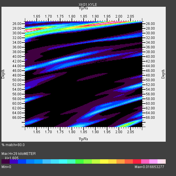
| Thickness Estimate: | 29 km |
| Thickness StdDev: | 15 km |
| Vp/Vs Estimate: | 1.61 |
| Vp/Vs StdDev: | 0.01 |
| Vs Estimate: | 3.91 km/s |
| Poisson's Ratio: | 0.18 |
| Peak Value: | 0.02 |
| Assumed Vp: | 6.276 km/s |
| Ps Weight: | 0.33333334 |
| PpPs Weight: | 0.33333334 |
| PsPs Weight: | 0.33333328 |
| Residual Complexity: | 0.709 |
| Nearby stations H: | +- |
| (2.0 deg) Vp/Vs: | +- |
2 with match > 90% ( 100.0 %) and 2 with match > 80% ( 100.0 %) out of 2.
Download stack as xyz text file.
Azimuth Distribution of Events:

Prior Results for this Station
| Study | Thickness | Vp/Vs | Vp | Vs | Poissons Ratio | Extra |
| EARS | 29 km | 1.61 | 6.276 km/s | 3.91 km/s | 0.18 | |
| Crust2.0 | 31 km | 1.78 | 6.276 km/s | 3.529 km/s | 0.27 | M5,extended crust, 0.5 km seds. |
| Global Maxima | 29 km | 1.61 | 6.276 km/s | 3.91 km/s | 0.18 | amp=0.016653277 |
| Local Maxima 1 | 25 km | 1.97 | 6.276 km/s | 3.182 km/s | 0.33 | amp=0.011507994 |
| Local Maxima 2 | 69 km | 2.02 | 6.276 km/s | 3.103 km/s | 0.34 | amp=0.008290261 |
| Local Maxima 3 | 70 km | 1.82 | 6.276 km/s | 3.453 km/s | 0.28 | amp=0.0073580467 |
| Local Maxima 4 | 46 km | 1.60 | 6.276 km/s | 3.922 km/s | 0.18 | amp=0.0064784065 |
| Predicted Arrivals for vertical incidence (zero ray parameter) | |
| Ps | 2.80 SECOND |
| PpPs | 12.04 SECOND |
| PsPs/PpSs | 14.83 SECOND |
Events Processed for this Station
Download zip of receiver functions as SAC
Plot maxima for each earthquake.
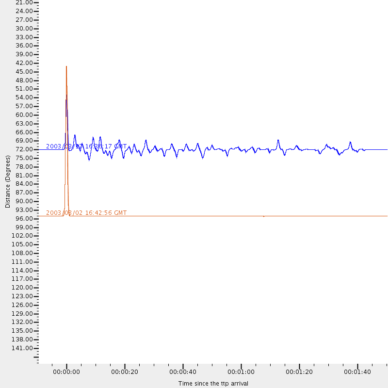
Events Used in the Stack
(2 events)| Radial Match | Distance | Baz | FERegion | Time | Lat/Lon | Depth | Magnitude |
| 99.98798 | 94.8 deg | 192.315 deg | Southern Mid-Atlantic Ridge | 2003/03/02 16:42:56 GMT | (-37.0, -20.9) | 10 km | 5.6 MB, 5.5 MS, 6.2 MW, 6.1 MW |
| 93.277405 | 71.8 deg | 357.707 deg | Rat Islands, Aleutian Islands | 2003/03/17 16:36:17 GMT | (51.3, 178.0) | 33 km | 5.9 MB, 6.7 MS, 7.0 MW, 7.0 MW |
Losers
(0 events)| Radial Match | Distance | Baz | FERegion | Time | Lat/Lon | Depth | Magnitude | Reason |
