
Station XK MILN - Milnahort
Network: XK01 - Reflections under the Scottish Highlands
Nearby stations (2 deg radius)
| Station | Name | (Lat, Lon) | Start / End | Elevation |
| MILN | Milnahort | (56.28, -3.45) | 2001-07-23 / 2003-12-31 | 0.3 km |
| Crust2 Type: | M5,extended crust, 0.5 km seds. |
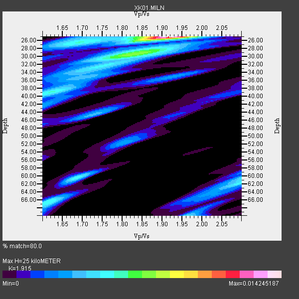
| Thickness Estimate: | 25 km |
| Thickness StdDev: | 13 km |
| Vp/Vs Estimate: | 1.91 |
| Vp/Vs StdDev: | 0.12 |
| Vs Estimate: | 3.277 km/s |
| Poisson's Ratio: | 0.31 |
| Peak Value: | 0.01 |
| Assumed Vp: | 6.276 km/s |
| Ps Weight: | 0.33333334 |
| PpPs Weight: | 0.33333334 |
| PsPs Weight: | 0.33333328 |
| Residual Complexity: | 0.706 |
| Nearby stations H: | +- |
| (2.0 deg) Vp/Vs: | +- |
3 with match > 90% ( 42.857143 %) and 7 with match > 80% ( 100.0 %) out of 7.
Download stack as xyz text file.
Azimuth Distribution of Events:

Prior Results for this Station
| Study | Thickness | Vp/Vs | Vp | Vs | Poissons Ratio | Extra |
| EARS | 25 km | 1.91 | 6.276 km/s | 3.277 km/s | 0.31 | |
| Crust2.0 | 31 km | 1.78 | 6.276 km/s | 3.529 km/s | 0.27 | M5,extended crust, 0.5 km seds. |
| Global Maxima | 25 km | 1.91 | 6.276 km/s | 3.277 km/s | 0.31 | amp=0.014245187 |
| Local Maxima 1 | 66 km | 1.62 | 6.276 km/s | 3.886 km/s | 0.19 | amp=0.005642094 |
| Local Maxima 2 | 29 km | 1.86 | 6.276 km/s | 3.383 km/s | 0.30 | amp=0.005196663 |
| Local Maxima 3 | 62 km | 2.09 | 6.276 km/s | 2.999 km/s | 0.35 | amp=0.0051959325 |
| Local Maxima 4 | 38 km | 1.64 | 6.276 km/s | 3.833 km/s | 0.20 | amp=0.004961292 |
| Predicted Arrivals for vertical incidence (zero ray parameter) | |
| Ps | 3.64 SECOND |
| PpPs | 11.61 SECOND |
| PsPs/PpSs | 15.26 SECOND |
Events Processed for this Station
Download zip of receiver functions as SAC
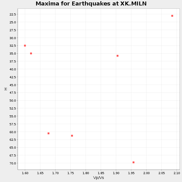
Plot maxima for each earthquake.
Events Used in the Stack
(7 events)| Radial Match | Distance | Baz | FERegion | Time | Lat/Lon | Depth | Magnitude |
| 95.40153 | 73.1 deg | 32.934 deg | E. Russia-N.E. China Border Reg. | 2002/06/28 17:19:30 GMT | (43.8, 130.7) | 566 km | 6.7 MB, 7.3 MW, 7.3 MW |
| 92.91628 | 72.8 deg | 359.058 deg | Rat Islands, Aleutian Islands | 2003/03/17 16:36:17 GMT | (51.3, 178.0) | 33 km | 5.9 MB, 6.7 MS, 7.0 MW, 7.0 MW |
| 90.88984 | 40.7 deg | 97.769 deg | Western Iran | 2002/06/22 02:58:21 GMT | (35.6, 49.0) | 10 km | 6.2 MB, 6.4 MS, 6.5 MW, 6.5 MW |
| 89.125084 | 88.1 deg | 47.629 deg | Taiwan Region | 2001/12/18 04:02:58 GMT | (24.0, 122.7) | 14 km | 6.3 MB, 7.3 MS, 6.9 MW, 6.8 MW |
| 82.7903 | 82.9 deg | 77.374 deg | Andaman Islands, India Region | 2002/09/13 22:28:29 GMT | (13.0, 93.1) | 21 km | 6.2 MB, 6.7 MS, 6.5 MW, 6.5 MW |
| 80.67797 | 77.1 deg | 257.474 deg | Colombia | 2001/09/22 03:23:38 GMT | (3.9, -76.0) | 179 km | 6.0 MB, 6.0 MW, 6.0 MW |
| 80.511566 | 67.3 deg | 7.672 deg | Near East Coast Of Kamchatka | 2001/08/02 23:41:06 GMT | (56.3, 163.8) | 14 km | 5.9 MB, 6.2 MS, 6.3 MW, 6.2 ME |
Losers
(0 events)| Radial Match | Distance | Baz | FERegion | Time | Lat/Lon | Depth | Magnitude | Reason |
