
Station XK B08TS - Tsao Primary School, Botswana
Network: XK12 - Seismic Arrays for African Rift Initation
Nearby stations (2 deg radius)
| Station | Name | (Lat, Lon) | Start / End | Elevation |
| B08TS | Tsao Primary School, Botswana | (-20.16, 22.46) | 2012-05-14 / 2014-08-30 | 948 m |
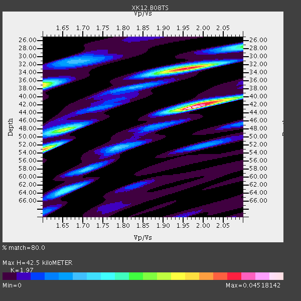
| Crust2 Type: | I3,late Proter., 3.5 km seds. |
| Thickness Estimate: | 42 km |
| Thickness StdDev: | 6.2 km |
| Vp/Vs Estimate: | 1.97 |
| Vp/Vs StdDev: | 0.15 |
| Vs Estimate: | 3.263 km/s |
| Poisson's Ratio: | 0.33 |
| Peak Value: | 0.05 |
| Assumed Vp: | 6.428 km/s |
| Ps Weight: | 0.33333334 |
| PpPs Weight: | 0.33333334 |
| PsPs Weight: | 0.33333328 |
| Residual Complexity: | 0.756 |
| Nearby stations H: | +- |
| (2.0 deg) Vp/Vs: | +- |
2 with match > 90% ( 6.451613 %) and 8 with match > 80% ( 25.806452 %) out of 31.
Download stack as xyz text file.
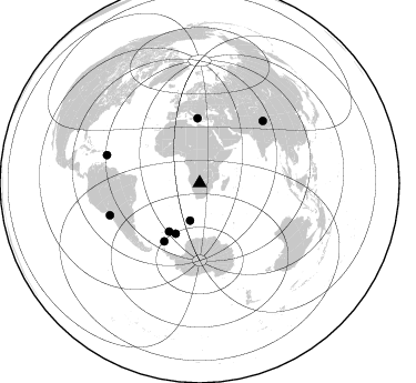
Azimuth Distribution of Events:
Prior Results for this Station
| Study | Thickness | Vp/Vs | Vp | Vs | Poissons Ratio | Extra |
| EARS | 42 km | 1.97 | 6.428 km/s | 3.263 km/s | 0.33 | |
| Crust2.0 | 41 km | 1.78 | 6.428 km/s | 3.601 km/s | 0.27 | I3,late Proter., 3.5 km seds. |
| Global Maxima | 42 km | 1.97 | 6.428 km/s | 3.263 km/s | 0.33 | amp=0.04518142 |
| Local Maxima 1 | 33 km | 1.96 | 6.428 km/s | 3.28 km/s | 0.32 | amp=0.03842703 |
| Local Maxima 2 | 53 km | 1.60 | 6.428 km/s | 4.011 km/s | 0.18 | amp=0.028731747 |
| Local Maxima 3 | 37 km | 1.60 | 6.428 km/s | 4.018 km/s | 0.18 | amp=0.023775822 |
| Local Maxima 4 | 64 km | 1.65 | 6.428 km/s | 3.896 km/s | 0.21 | amp=0.017984625 |
| Predicted Arrivals for vertical incidence (zero ray parameter) | |
| Ps | 6.41 SECOND |
| PpPs | 19.64 SECOND |
| PsPs/PpSs | 26.05 SECOND |
Events Processed for this Station
Download zip of receiver functions as SAC
Plot maxima for each earthquake.
Events Used in the Stack
(8 events)| Radial Match | Distance | Baz | FERegion | Time | Lat/Lon | Depth | Magnitude |
| 93.012085 | 50.3 deg | 205.4 deg | East Of South Sandwich Islands | 2014/03/11 02:44:05 GMT | (-60.9, -20.0) | 10 km | 6.4 MWW, 6.4 MWB, 6.4 MWC, 6.8 MI |
| 92.47773 | 51.7 deg | 212.34 deg | South Sandwich Islands Region | 2014/02/01 03:58:43 GMT | (-56.8, -27.3) | 130 km | 6.1 MWW, 6.1 MWC, 6.1 MWB, 6.2 MWC |
| 89.77701 | 34.9 deg | 194.349 deg | Bouvet Island Region | 2014/04/15 03:57:02 GMT | (-53.5, 8.7) | 12 km | 6.9 MWP, 6.8 MI, 6.9 MI |
| 89.491264 | 58.1 deg | 358.083 deg | Greece | 2014/02/03 03:08:46 GMT | (38.3, 20.4) | 5.0 km | 6.0 MWW, 6.0 MWB, 6.1 MWC |
| 83.510765 | 87.1 deg | 286.627 deg | North Atlantic Ocean | 2014/02/18 09:27:13 GMT | (14.7, -58.9) | 17 km | 6.5 MWW, 6.3 MWB, 6.5 MWC, 6.6 MWC, 6.7 MI |
| 82.395905 | 86.1 deg | 250.342 deg | Near Coast Of Northern Chile | 2014/03/16 21:16:30 GMT | (-19.9, -70.6) | 20 km | 6.7 MWW, 6.7 MWC, 7.0 MI |
| 81.98105 | 79.6 deg | 45.696 deg | Xizang | 2014/02/12 09:19:49 GMT | (35.9, 82.6) | 10 km | 6.9 MWW, 6.9 MWB, 6.9 MWC |
| 80.44355 | 61.7 deg | 211.419 deg | Scotia Sea | 2014/02/08 19:50:36 GMT | (-60.4, -45.2) | 24 km | 5.7 MWW, 5.6 MWB, 5.8 MWC |
Losers
(23 events)| Radial Match | Distance | Baz | FERegion | Time | Lat/Lon | Depth | Magnitude | Reason |
| 91.67293 | 86.3 deg | 250.546 deg | Near Coast Of Northern Chile | 2014/04/01 23:46:46 GMT | (-19.6, -70.8) | 20 km | 8.2 MWW, 8.0 MI, 8.1 MWC | |
| 90.7378 | 86.0 deg | 250.29 deg | Near Coast Of Northern Chile | 2014/04/02 00:37:49 GMT | (-20.0, -70.6) | 20 km | 5.4 mb | |
| 73.13843 | 85.9 deg | 249.539 deg | Near Coast Of Northern Chile | 2014/04/11 00:01:44 GMT | (-20.7, -70.7) | 18 km | 6.0 MB | |
| 70.82884 | 86.2 deg | 250.252 deg | Near Coast Of Northern Chile | 2014/03/18 21:26:45 GMT | (-20.0, -70.8) | 3.8 km | 5.8 MWW, 5.9 MWC, 6.0 MWR, 6.0 MWB | |
| 69.943275 | 85.9 deg | 250.043 deg | Near Coast Of Northern Chile | 2014/04/03 01:58:31 GMT | (-20.3, -70.6) | 23 km | 6.5 MWW, 6.5 MWB, 6.6 MWC | |
| 68.53998 | 85.7 deg | 249.54 deg | Near Coast Of Northern Chile | 2014/04/03 05:26:16 GMT | (-20.8, -70.5) | 24 km | 6.2 MWP, 6.2 MWR, 6.3 MWW, 6.5 MWC | |
| 68.47444 | 86.3 deg | 250.272 deg | Near Coast Of Northern Chile | 2014/04/01 23:57:57 GMT | (-19.9, -70.9) | 20 km | 6.9 MWW, 6.9 MWC | |
| 67.503654 | 57.1 deg | 1.245 deg | Southern Greece | 2014/04/04 20:08:07 GMT | (37.2, 23.8) | 107 km | 5.5 MWB, 5.5 MWR, 5.6 MWC, 5.6 MWW | |
| 66.24921 | 82.6 deg | 237.909 deg | Near Coast Of Central Chile | 2014/04/05 02:22:38 GMT | (-32.8, -71.6) | 40 km | 5.6 MWC, 5.6 MWC | |
| 65.9904 | 86.3 deg | 250.337 deg | Near Coast Of Northern Chile | 2014/04/02 00:03:12 GMT | (-19.8, -70.9) | 10 km | 5.8 MB | |
| 64.08911 | 85.9 deg | 249.653 deg | Near Coast Of Northern Chile | 2014/04/04 01:37:51 GMT | (-20.6, -70.7) | 20 km | 6.1 MWP, 6.1 MWB, 6.1 MWW, 6.3 MWC | |
| 62.422836 | 33.4 deg | 176.876 deg | South Of Africa | 2014/03/14 20:32:09 GMT | (-53.6, 25.3) | 10 km | 5.5 MW | |
| 62.30313 | 37.8 deg | 217.672 deg | Southern Mid-Atlantic Ridge | 2014/04/01 23:13:05 GMT | (-46.8, -10.6) | 10 km | 5.6 MW | |
| 62.291412 | 86.3 deg | 250.386 deg | Near Coast Of Northern Chile | 2014/03/24 11:40:44 GMT | (-19.8, -70.8) | 23 km | 5.5 MB, 5.5 MWR, 5.6 MWW, 5.7 MWC | |
| 58.929615 | 96.8 deg | 100.651 deg | Flores Sea | 2014/04/02 03:01:26 GMT | (-7.6, 122.6) | 35 km | 4.6 mb | |
| 58.723087 | 67.6 deg | 76.302 deg | North Indian Ocean | 2014/03/27 04:00:17 GMT | (4.3, 86.7) | 29 km | 5.3 MW | |
| 58.30275 | 64.9 deg | 21.982 deg | Eastern Caucasus | 2014/02/10 12:06:46 GMT | (40.3, 48.8) | 63 km | 5.5 MW | |
| 55.825138 | 82.6 deg | 237.04 deg | Near Coast Of Central Chile | 2014/03/04 10:51:15 GMT | (-33.6, -72.0) | 20 km | 5.7 MWW, 5.7 MWB, 5.8 MWC | |
| 53.807556 | 86.3 deg | 250.453 deg | Near Coast Of Northern Chile | 2014/03/23 18:20:03 GMT | (-19.7, -70.8) | 35 km | 6.0 MB, 6.2 MWB, 6.2 MWW, 6.3 MWC | |
| 52.139828 | 86.1 deg | 250.267 deg | Near Coast Of Northern Chile | 2014/03/17 08:32:37 GMT | (-20.0, -70.7) | 15 km | 5.1 MW | |
| 49.697887 | 86.0 deg | 250.235 deg | Near Coast Of Northern Chile | 2014/04/11 12:00:51 GMT | (-20.1, -70.5) | 22 km | 5.5 MB | |
| 40.215405 | 82.1 deg | 236.006 deg | Near Coast Of Central Chile | 2014/03/15 14:46:28 GMT | (-34.7, -71.8) | 45 km | 5.5 MB, 5.1 MWW | |
| 23.634811 | 94.9 deg | 99.352 deg | Flores Sea | 2014/01/23 00:52:15 GMT | (-7.1, 120.3) | 579 km | 5.5 MWB, 5.5 MWC |

