
Station XK B11ET - ETS13 Primary School, Botswana
Network: XK12 - Seismic Arrays for African Rift Initation
Nearby stations (2 deg radius)
| Station | Name | (Lat, Lon) | Start / End | Elevation |
| B11ET | ETS13 Primary School, Botswana | (-19.02, 22.32) | 2012-05-14 / 2014-08-30 | 974 m |
| Crust2 Type: | H4,early/mid Proter. shield, Africa, 1.5 km seds. |
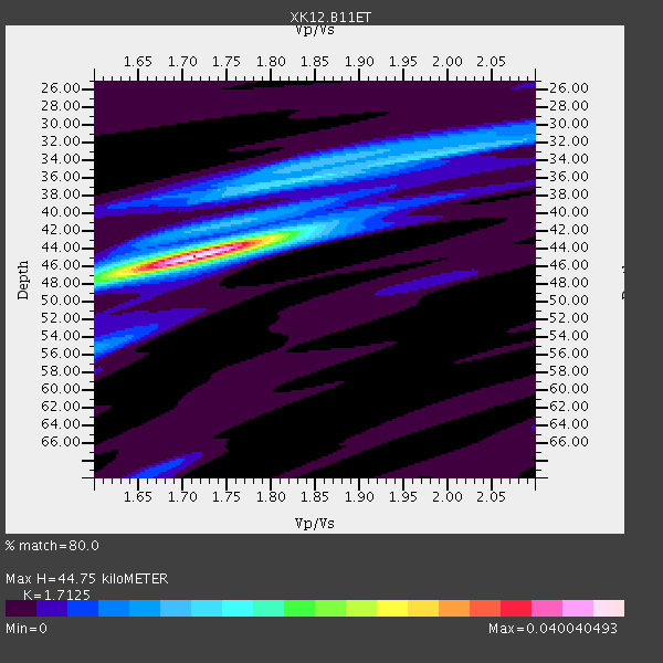
| Thickness Estimate: | 45 km |
| Thickness StdDev: | 2.1 km |
| Vp/Vs Estimate: | 1.71 |
| Vp/Vs StdDev: | 0.03 |
| Vs Estimate: | 3.805 km/s |
| Poisson's Ratio: | 0.24 |
| Peak Value: | 0.04 |
| Assumed Vp: | 6.516 km/s |
| Ps Weight: | 0.33333334 |
| PpPs Weight: | 0.33333334 |
| PsPs Weight: | 0.33333328 |
| Residual Complexity: | 0.486 |
| Nearby stations H: | +- |
| (2.0 deg) Vp/Vs: | +- |
2 with match > 90% ( 9.523809 %) and 7 with match > 80% ( 33.333332 %) out of 21.
Download stack as xyz text file.
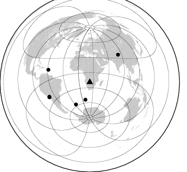
Azimuth Distribution of Events:
Prior Results for this Station
| Study | Thickness | Vp/Vs | Vp | Vs | Poissons Ratio | Extra |
| EARS | 45 km | 1.71 | 6.516 km/s | 3.805 km/s | 0.24 | |
| Crust2.0 | 46 km | 1.78 | 6.516 km/s | 3.661 km/s | 0.27 | H4,early/mid Proter. shield, Africa, 1.5 km seds. |
| Global Maxima | 45 km | 1.71 | 6.516 km/s | 3.805 km/s | 0.24 | amp=0.040040493 |
| Local Maxima 1 | 36 km | 1.84 | 6.516 km/s | 3.546 km/s | 0.29 | amp=0.013489605 |
| Local Maxima 2 | 42 km | 1.81 | 6.516 km/s | 3.605 km/s | 0.28 | amp=0.010084499 |
| Local Maxima 3 | 32 km | 2.03 | 6.516 km/s | 3.214 km/s | 0.34 | amp=0.009063931 |
| Local Maxima 4 | 55 km | 1.60 | 6.516 km/s | 4.073 km/s | 0.18 | amp=0.0059771123 |
| Predicted Arrivals for vertical incidence (zero ray parameter) | |
| Ps | 4.89 SECOND |
| PpPs | 18.63 SECOND |
| PsPs/PpSs | 23.52 SECOND |
Events Processed for this Station
Download zip of receiver functions as SAC
Plot maxima for each earthquake.
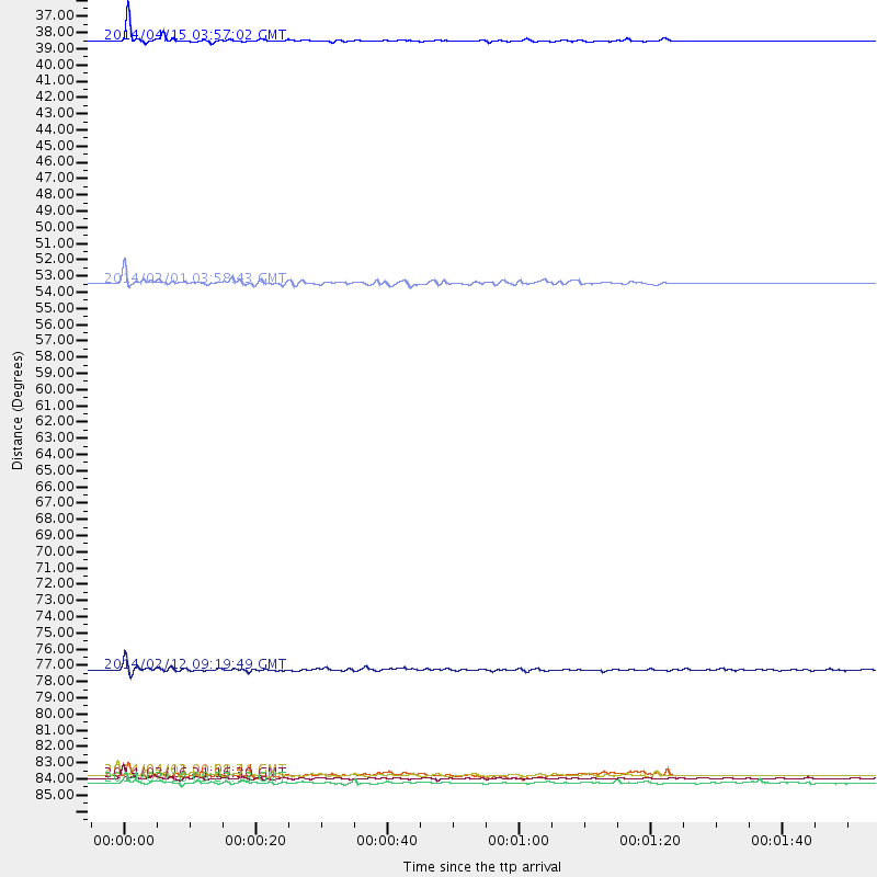
Events Used in the Stack
(7 events)| Radial Match | Distance | Baz | FERegion | Time | Lat/Lon | Depth | Magnitude |
| 97.02662 | 86.3 deg | 250.315 deg | Near Coast Of Northern Chile | 2014/03/16 21:16:30 GMT | (-19.9, -70.6) | 20 km | 6.7 MWW, 6.7 MWC, 7.0 MI |
| 94.957214 | 36.0 deg | 193.823 deg | Bouvet Island Region | 2014/04/15 03:57:02 GMT | (-53.5, 8.7) | 12 km | 6.9 MWP, 6.8 MI, 6.9 MI |
| 88.44451 | 86.7 deg | 286.617 deg | North Atlantic Ocean | 2014/02/18 09:27:13 GMT | (14.7, -58.9) | 17 km | 6.5 MWW, 6.3 MWB, 6.5 MWC, 6.6 MWC, 6.7 MI |
| 87.7397 | 86.2 deg | 250.013 deg | Near Coast Of Northern Chile | 2014/04/03 01:58:31 GMT | (-20.3, -70.6) | 23 km | 6.5 MWW, 6.5 MWB, 6.6 MWC |
| 86.770805 | 52.6 deg | 211.828 deg | South Sandwich Islands Region | 2014/02/01 03:58:43 GMT | (-56.8, -27.3) | 130 km | 6.1 MWW, 6.1 MWC, 6.1 MWB, 6.2 MWC |
| 83.842766 | 78.9 deg | 45.917 deg | Xizang | 2014/02/12 09:19:49 GMT | (35.9, 82.6) | 10 km | 6.9 MWW, 6.9 MWB, 6.9 MWC |
| 80.88944 | 86.2 deg | 249.509 deg | Near Coast Of Northern Chile | 2014/04/11 00:01:44 GMT | (-20.7, -70.7) | 18 km | 6.0 MB |
Losers
(14 events)| Radial Match | Distance | Baz | FERegion | Time | Lat/Lon | Depth | Magnitude | Reason |
| 99.275116 | 86.6 deg | 250.524 deg | Near Coast Of Northern Chile | 2014/04/01 23:46:46 GMT | (-19.6, -70.8) | 20 km | 8.2 MWW, 8.0 MI, 8.1 MWC | |
| 79.71525 | 51.3 deg | 204.953 deg | East Of South Sandwich Islands | 2014/03/11 02:44:05 GMT | (-60.9, -20.0) | 10 km | 6.4 MWW, 6.4 MWB, 6.4 MWC, 6.8 MI | |
| 70.56292 | 86.5 deg | 250.228 deg | Near Coast Of Northern Chile | 2014/03/18 21:26:45 GMT | (-20.0, -70.8) | 3.8 km | 5.8 MWW, 5.9 MWC, 6.0 MWR, 6.0 MWB | |
| 69.05528 | 86.2 deg | 249.624 deg | Near Coast Of Northern Chile | 2014/04/04 01:37:51 GMT | (-20.6, -70.7) | 20 km | 6.1 MWP, 6.1 MWB, 6.1 MWW, 6.3 MWC | |
| 67.615265 | 34.6 deg | 176.818 deg | South Of Africa | 2014/03/14 20:32:09 GMT | (-53.6, 25.3) | 10 km | 5.5 MW | |
| 67.43252 | 86.2 deg | 249.545 deg | Near Coast Of Northern Chile | 2014/01/04 00:11:48 GMT | (-20.7, -70.8) | 26 km | 5.7 MWW, 5.8 MWB, 5.8 MWC | |
| 59.45246 | 93.4 deg | 253.944 deg | Near Coast Of Peru | 2014/03/15 08:59:21 GMT | (-14.1, -76.3) | 20 km | 6.1 MWW, 6.0 MWB, 6.2 MWC | |
| 57.915436 | 83.1 deg | 237.826 deg | Near Coast Of Central Chile | 2014/04/05 02:22:38 GMT | (-32.8, -71.6) | 40 km | 5.6 MWC, 5.6 MWC | |
| 54.22609 | 86.0 deg | 249.506 deg | Near Coast Of Northern Chile | 2014/04/03 05:26:16 GMT | (-20.8, -70.5) | 24 km | 6.2 MWP, 6.2 MWR, 6.3 MWW, 6.5 MWC | |
| 53.534237 | 84.5 deg | 96.699 deg | Java, Indonesia | 2014/01/27 16:14:00 GMT | (-8.2, 109.2) | 83 km | 5.0 MW | |
| 44.93488 | 75.7 deg | 76.506 deg | Nicobar Islands, India Region | 2014/03/14 13:38:06 GMT | (7.8, 94.3) | 10 km | 5.5 MWW, 5.4 MWB, 5.6 MWC | |
| 44.192425 | 86.6 deg | 250.163 deg | Near Coast Of Northern Chile | 2014/04/02 11:07:33 GMT | (-20.0, -71.0) | 27 km | 5.4 Mww | |
| 40.008923 | 56.9 deg | 38.291 deg | Southern Iran | 2014/02/02 14:26:47 GMT | (26.6, 57.8) | 19 km | 5.3 MW | |
| 32.927586 | 78.4 deg | 82.929 deg | Northern Sumatra, Indonesia | 2014/03/15 10:58:46 GMT | (2.8, 99.1) | 171 km | 5.6 MB, 5.4 MWC |

