
Station XK W08KB - Nkhata Bay Police Station, Malawi
Network: XK12 - Seismic Arrays for African Rift Initation
Nearby stations (2 deg radius)
| Station | Name | (Lat, Lon) | Start / End | Elevation |
| W08KB | Nkhata Bay Police Station, Malawi | (-11.61, 34.30) | 2012-06-01 / 2014-08-30 | 481 m |
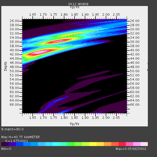
| Crust2 Type: | X2,Rift, Rio Grande, Baikal, 0.5km sediments |
| Thickness Estimate: | 41 km |
| Thickness StdDev: | 4.0 km |
| Vp/Vs Estimate: | 1.68 |
| Vp/Vs StdDev: | 0.10 |
| Vs Estimate: | 3.882 km/s |
| Poisson's Ratio: | 0.22 |
| Peak Value: | 0.05 |
| Assumed Vp: | 6.502 km/s |
| Ps Weight: | 0.33333334 |
| PpPs Weight: | 0.33333334 |
| PsPs Weight: | 0.33333328 |
| Residual Complexity: | 0.704 |
| Nearby stations H: | +- |
| (2.0 deg) Vp/Vs: | +- |
0 with match > 90% ( 0.0 %) and 2 with match > 80% ( 6.8965516 %) out of 29.
Download stack as xyz text file.
Azimuth Distribution of Events:

Prior Results for this Station
| Study | Thickness | Vp/Vs | Vp | Vs | Poissons Ratio | Extra |
| EARS | 41 km | 1.68 | 6.502 km/s | 3.882 km/s | 0.22 | |
| Crust2.0 | 33 km | 1.77 | 6.502 km/s | 3.68 km/s | 0.26 | X2,Rift, Rio Grande, Baikal, 0.5km sediments |
| Global Maxima | 41 km | 1.68 | 6.502 km/s | 3.882 km/s | 0.22 | amp=0.054925602 |
| Local Maxima 1 | 35 km | 1.78 | 6.502 km/s | 3.647 km/s | 0.27 | amp=0.043755855 |
| Local Maxima 2 | 32 km | 1.86 | 6.502 km/s | 3.505 km/s | 0.30 | amp=0.035411768 |
| Local Maxima 3 | 44 km | 1.66 | 6.502 km/s | 3.922 km/s | 0.21 | amp=0.016724618 |
| Local Maxima 4 | 35 km | 1.65 | 6.502 km/s | 3.934 km/s | 0.21 | amp=0.014771535 |
| Predicted Arrivals for vertical incidence (zero ray parameter) | |
| Ps | 4.23 SECOND |
| PpPs | 16.77 SECOND |
| PsPs/PpSs | 21.00 SECOND |
Events Processed for this Station
Download zip of receiver functions as SAC
Plot maxima for each earthquake.
Events Used in the Stack
(2 events)| Radial Match | Distance | Baz | FERegion | Time | Lat/Lon | Depth | Magnitude |
| 86.44328 | 46.5 deg | 200.815 deg | Bouvet Island Region | 2014/04/15 03:57:02 GMT | (-53.5, 8.7) | 12 km | 6.9 MWP, 6.8 MI, 6.9 MI |
| 86.387184 | 65.6 deg | 41.706 deg | Xizang | 2014/02/12 09:19:49 GMT | (35.9, 82.6) | 10 km | 6.9 MWW, 6.9 MWB, 6.9 MWC |
Losers
(27 events)| Radial Match | Distance | Baz | FERegion | Time | Lat/Lon | Depth | Magnitude | Reason |
| 83.75104 | 51.3 deg | 345.969 deg | Greece | 2014/02/03 03:08:46 GMT | (38.3, 20.4) | 5.0 km | 6.0 MWW, 6.0 MWB, 6.1 MWC | |
| 80.412445 | 95.1 deg | 97.388 deg | Banda Sea | 2014/02/11 10:16:58 GMT | (-6.2, 130.8) | 86 km | 5.0 MW | |
| 78.289665 | 95.8 deg | 98.426 deg | Tanimbar Islands Reg., Indonesia | 2014/04/07 12:56:34 GMT | (-7.1, 131.7) | 36 km | 4.8 mb | |
| 74.13022 | 86.8 deg | 97.093 deg | Flores Sea | 2014/04/02 03:01:26 GMT | (-7.6, 122.6) | 35 km | 4.6 mb | |
| 71.84404 | 92.3 deg | 97.78 deg | Banda Sea | 2014/02/03 22:36:37 GMT | (-7.2, 128.2) | 7.1 km | 5.8 MWW, 5.8 MWB, 5.9 MWC | |
| 71.1846 | 73.8 deg | 95.01 deg | Java, Indonesia | 2014/01/25 05:14:18 GMT | (-8.0, 109.3) | 66 km | 6.1 MWW, 6.1 MWC, 6.2 MWC, 6.2 MWB | |
| 70.403336 | 65.0 deg | 212.265 deg | South Sandwich Islands Region | 2014/02/01 03:58:43 GMT | (-56.8, -27.3) | 130 km | 6.1 MWW, 6.1 MWC, 6.1 MWB, 6.2 MWC | |
| 67.30661 | 63.7 deg | 82.908 deg | Northern Sumatra, Indonesia | 2014/02/23 01:47:05 GMT | (1.1, 97.1) | 25 km | 5.0 MW | |
| 66.33992 | 94.5 deg | 80.182 deg | Philippine Islands Region | 2014/03/15 10:55:11 GMT | (10.6, 126.8) | 11 km | 5.3 MW | |
| 65.83729 | 84.7 deg | 96.146 deg | Flores Sea | 2014/01/23 00:52:15 GMT | (-7.1, 120.3) | 579 km | 5.5 MWB, 5.5 MWC | |
| 64.92457 | 97.1 deg | 233.912 deg | Off Coast Of Central Chile | 2014/04/11 01:08:01 GMT | (-33.4, -72.2) | 12 km | 5.0 mb | |
| 61.82785 | 51.5 deg | 218.268 deg | Southern Mid-Atlantic Ridge | 2014/04/01 23:13:05 GMT | (-46.8, -10.6) | 10 km | 5.6 MW | |
| 61.08818 | 94.6 deg | 87.67 deg | North Of Halmahera, Indonesia | 2014/01/05 11:44:09 GMT | (3.2, 128.3) | 35 km | 4.9 MW | |
| 60.839256 | 51.2 deg | 345.901 deg | Greece | 2014/02/03 03:16:14 GMT | (38.2, 20.3) | 13 km | 4.1 mb | |
| 60.777107 | 95.5 deg | 238.918 deg | San Juan Province, Argentina | 2014/03/27 23:50:52 GMT | (-29.1, -68.7) | 9.9 km | 5.5 MWP, 5.6 MWB, 5.7 MWW, 5.7 MWC | |
| 59.819332 | 97.9 deg | 63.658 deg | Ryukyu Islands, Japan | 2014/03/02 20:11:23 GMT | (27.4, 127.4) | 119 km | 6.5 MWW, 6.4 MWB, 6.5 MWC, 6.6 MI, 6.7 MI | |
| 57.799507 | 94.1 deg | 98.098 deg | Banda Sea | 2014/03/10 17:31:33 GMT | (-7.1, 130.0) | 150 km | 5.0 mb | |
| 57.554207 | 96.4 deg | 234.251 deg | Near Coast Of Central Chile | 2014/03/06 04:37:05 GMT | (-33.3, -71.3) | 59 km | 5.4 MW | |
| 57.55013 | 93.6 deg | 64.891 deg | Taiwan Region | 2014/01/06 18:49:40 GMT | (25.5, 122.8) | 236 km | 5.0 MW | |
| 57.24021 | 92.4 deg | 97.849 deg | Banda Sea | 2014/02/03 20:37:18 GMT | (-7.2, 128.2) | 35 km | 5.0 MW | |
| 55.93743 | 94.4 deg | 97.465 deg | Banda Sea | 2014/02/21 08:32:47 GMT | (-6.5, 130.1) | 146 km | 4.8 mb | |
| 54.02553 | 92.5 deg | 98.066 deg | Banda Sea | 2014/02/04 01:05:34 GMT | (-7.4, 128.4) | 35 km | 5.1 MW | |
| 53.729034 | 67.3 deg | 91.032 deg | Southern Sumatra, Indonesia | 2014/04/03 09:30:19 GMT | (-5.4, 102.1) | 11 km | 5.6 MB, 5.9 MWC | |
| 49.393 | 71.6 deg | 93.158 deg | Java, Indonesia | 2014/01/15 09:26:11 GMT | (-6.6, 106.7) | 129 km | 4.5 mb | |
| 47.986 | 60.7 deg | 80.793 deg | Off W Coast Of Northern Sumatra | 2014/01/14 10:36:10 GMT | (2.2, 93.7) | 35 km | 4.7 mb | |
| 46.85927 | 66.8 deg | 216.961 deg | South Georgia Island Region | 2014/03/17 13:24:48 GMT | (-53.2, -32.3) | 5.4 km | 5.6 MB, 5.8 MWB, 5.9 MWC | |
| 42.147972 | 64.8 deg | 70.449 deg | Andaman Islands, India Region | 2014/02/02 23:43:59 GMT | (12.3, 95.1) | 24 km | 5.4 MW |

