
Station XK W15SS - Geological Survey Seismic Station, Blantyre, Malaw
Network: XK12 - Seismic Arrays for African Rift Initation
Nearby stations (2 deg radius)
| Station | Name | (Lat, Lon) | Start / End | Elevation |
| W15SS | Geological Survey Seismic Station, Blantyre, Malaw | (-15.68, 34.97) | 2012-06-01 / 2014-08-30 | 777 m |
| Crust2 Type: | X2,Rift, Rio Grande, Baikal, 0.5km sediments |
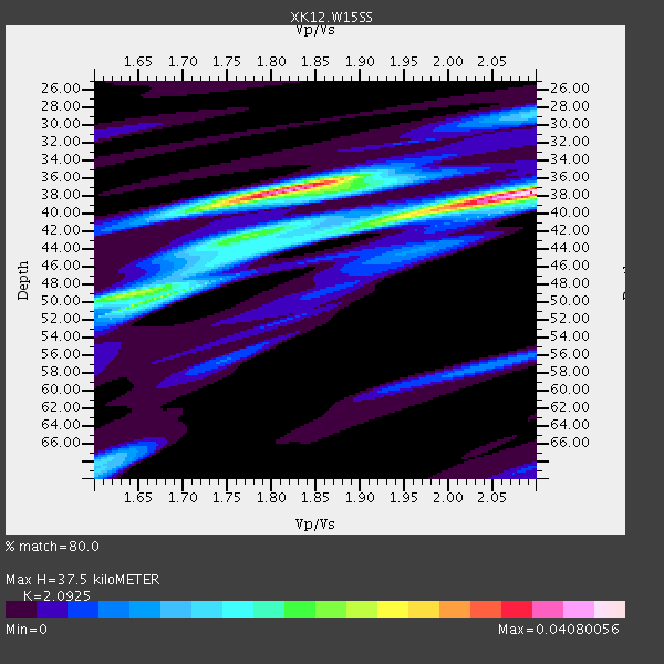
| Thickness Estimate: | 38 km |
| Thickness StdDev: | 1.9 km |
| Vp/Vs Estimate: | 2.09 |
| Vp/Vs StdDev: | 0.19 |
| Vs Estimate: | 3.107 km/s |
| Poisson's Ratio: | 0.35 |
| Peak Value: | 0.04 |
| Assumed Vp: | 6.502 km/s |
| Ps Weight: | 0.33333334 |
| PpPs Weight: | 0.33333334 |
| PsPs Weight: | 0.33333328 |
| Residual Complexity: | 0.785 |
| Nearby stations H: | +- |
| (2.0 deg) Vp/Vs: | +- |
1 with match > 90% ( 4.1666665 %) and 2 with match > 80% ( 8.333333 %) out of 24.
Download stack as xyz text file.
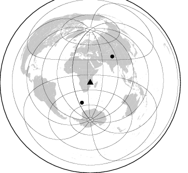
Azimuth Distribution of Events:
Prior Results for this Station
| Study | Thickness | Vp/Vs | Vp | Vs | Poissons Ratio | Extra |
| EARS | 38 km | 2.09 | 6.502 km/s | 3.107 km/s | 0.35 | |
| Crust2.0 | 33 km | 1.77 | 6.502 km/s | 3.68 km/s | 0.26 | X2,Rift, Rio Grande, Baikal, 0.5km sediments |
| Global Maxima | 38 km | 2.09 | 6.502 km/s | 3.107 km/s | 0.35 | amp=0.04080056 |
| Local Maxima 1 | 37 km | 1.82 | 6.502 km/s | 3.577 km/s | 0.28 | amp=0.03733808 |
| Local Maxima 2 | 49 km | 1.68 | 6.502 km/s | 3.864 km/s | 0.23 | amp=0.02419099 |
| Local Maxima 3 | 41 km | 1.93 | 6.502 km/s | 3.373 km/s | 0.32 | amp=0.015990203 |
| Local Maxima 4 | 49 km | 1.63 | 6.502 km/s | 3.976 km/s | 0.20 | amp=0.014778115 |
| Predicted Arrivals for vertical incidence (zero ray parameter) | |
| Ps | 6.30 SECOND |
| PpPs | 17.84 SECOND |
| PsPs/PpSs | 24.14 SECOND |
Events Processed for this Station
Download zip of receiver functions as SAC
Plot maxima for each earthquake.
Events Used in the Stack
(2 events)| Radial Match | Distance | Baz | FERegion | Time | Lat/Lon | Depth | Magnitude |
| 96.841225 | 43.0 deg | 202.79 deg | Bouvet Island Region | 2014/04/15 03:57:02 GMT | (-53.5, 8.7) | 12 km | 6.9 MWP, 6.8 MI, 6.9 MI |
| 85.81351 | 68.3 deg | 40.206 deg | Xizang | 2014/02/12 09:19:49 GMT | (35.9, 82.6) | 10 km | 6.9 MWW, 6.9 MWB, 6.9 MWC |
Losers
(22 events)| Radial Match | Distance | Baz | FERegion | Time | Lat/Lon | Depth | Magnitude | Reason |
| 87.19002 | 55.4 deg | 346.061 deg | Greece | 2014/02/03 03:08:46 GMT | (38.3, 20.4) | 5.0 km | 6.0 MWW, 6.0 MWB, 6.1 MWC | |
| 79.789764 | 55.3 deg | 346.099 deg | Greece | 2014/01/26 13:55:42 GMT | (38.2, 20.5) | 8.0 km | 6.1 MWW, 6.1 MWB, 6.2 MWC | |
| 77.084274 | 61.9 deg | 213.481 deg | South Sandwich Islands Region | 2014/02/01 03:58:43 GMT | (-56.8, -27.3) | 130 km | 6.1 MWW, 6.1 MWC, 6.1 MWB, 6.2 MWC | |
| 74.5118 | 68.1 deg | 40.207 deg | Xizang | 2014/02/12 09:24:43 GMT | (35.8, 82.5) | 10 km | 5.7 MB | |
| 65.87105 | 94.4 deg | 231.923 deg | Central Chile | 2014/03/04 11:24:20 GMT | (-35.0, -72.0) | 48 km | 4.9 mb | |
| 64.81941 | 83.6 deg | 95.583 deg | Flores Sea | 2014/01/23 00:52:15 GMT | (-7.1, 120.3) | 579 km | 5.5 MWB, 5.5 MWC | |
| 64.61551 | 95.0 deg | 66.044 deg | Southwestern Ryukyu Isl., Japan | 2014/01/08 18:15:11 GMT | (24.5, 123.5) | 73 km | 5.3 MW | |
| 62.349205 | 64.0 deg | 218.173 deg | South Georgia Island Region | 2014/03/17 13:24:48 GMT | (-53.2, -32.3) | 5.4 km | 5.6 MB, 5.8 MWB, 5.9 MWC | |
| 59.74952 | 95.0 deg | 234.128 deg | Near Coast Of Central Chile | 2014/04/05 02:22:38 GMT | (-32.8, -71.6) | 40 km | 5.6 MWC, 5.6 MWC | |
| 57.053173 | 92.3 deg | 94.077 deg | Seram, Indonesia | 2014/03/24 10:21:34 GMT | (-3.3, 128.3) | 91 km | 4.1 mb | |
| 55.94822 | 53.7 deg | 348.901 deg | Southern Greece | 2014/04/04 20:08:07 GMT | (37.2, 23.8) | 107 km | 5.5 MWB, 5.5 MWR, 5.6 MWC, 5.6 MWW | |
| 53.68746 | 61.9 deg | 32.287 deg | Hindu Kush Region, Afghanistan | 2014/03/19 14:15:43 GMT | (36.5, 70.7) | 193 km | 4.7 mb | |
| 52.885437 | 96.3 deg | 244.921 deg | Northern Chile | 2014/02/10 11:00:09 GMT | (-22.3, -68.7) | 107 km | 5.2 MW | |
| 51.726616 | 93.9 deg | 66.205 deg | Taiwan Region | 2014/03/19 12:19:24 GMT | (24.1, 122.3) | 10 km | 5.6 MWB, 5.8 MWW, 5.8 MWC | |
| 50.57034 | 90.7 deg | 71.066 deg | Luzon, Philippines | 2014/02/17 05:55:59 GMT | (18.5, 120.4) | 20 km | 5.5 MWW, 5.5 MWB, 5.6 MWC | |
| 48.7835 | 93.4 deg | 98.102 deg | Banda Sea | 2014/01/18 09:34:21 GMT | (-6.9, 130.4) | 150 km | 4.7 mb | |
| 48.092327 | 55.4 deg | 346.07 deg | Greece | 2014/01/26 18:45:08 GMT | (38.2, 20.4) | 16 km | 5.4 MW | |
| 39.5374 | 93.5 deg | 97.495 deg | Banda Sea | 2014/01/25 01:15:40 GMT | (-6.3, 130.4) | 150 km | 4.6 mb | |
| 33.90359 | 80.4 deg | 95.317 deg | Bali Sea | 2014/03/06 10:23:59 GMT | (-7.7, 117.1) | 299 km | 5.1 MW | |
| 24.122517 | 89.6 deg | 85.814 deg | Celebes Sea | 2014/03/18 14:00:07 GMT | (4.0, 123.5) | 500 km | 4.8 mb | |
| 23.434423 | 89.0 deg | 75.574 deg | Mindoro, Philippines | 2014/01/21 10:35:16 GMT | (13.7, 120.1) | 46 km | 4.7 mb | |
| 18.601149 | 91.2 deg | 97.813 deg | Banda Sea | 2014/02/03 20:37:18 GMT | (-7.2, 128.2) | 35 km | 5.0 MW |

