
Station XK 5130 - twist97_5130
Network: XK97 - Western Superior Teleseismic Experiment
Nearby stations (2 deg radius)

| Station | Name | (Lat, Lon) | Start / End | Elevation |
| 5130 | twist97_5130 | (50.36, -90.67) | 1997-05-15 / 1997-12-31 | 387 m |
| Crust2 Type: | G1,Archean, no seds. |
| Thickness Estimate: | 42 km |
| Thickness StdDev: | 2.7 km |
| Vp/Vs Estimate: | 1.73 |
| Vp/Vs StdDev: | 0.07 |
| Vs Estimate: | 3.728 km/s |
| Poisson's Ratio: | 0.25 |
| Peak Value: | 0.03 |
| Assumed Vp: | 6.459 km/s |
| Ps Weight: | 0.33333334 |
| PpPs Weight: | 0.33333334 |
| PsPs Weight: | 0.33333328 |
| Residual Complexity: | 0.564 |
| Nearby stations H: | +- |
| (2.0 deg) Vp/Vs: | +- |
3 with match > 90% ( 15.0 %) and 6 with match > 80% ( 30.0 %) out of 20.
Download stack as xyz text file.
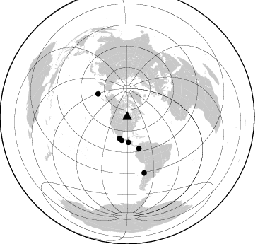
Azimuth Distribution of Events:
Prior Results for this Station
| Study | Thickness | Vp/Vs | Vp | Vs | Poissons Ratio | Extra |
| EARS | 42 km | 1.73 | 6.459 km/s | 3.728 km/s | 0.25 | |
| Crust2.0 | 37 km | 1.76 | 6.459 km/s | 3.665 km/s | 0.26 | G1,Archean, no seds. |
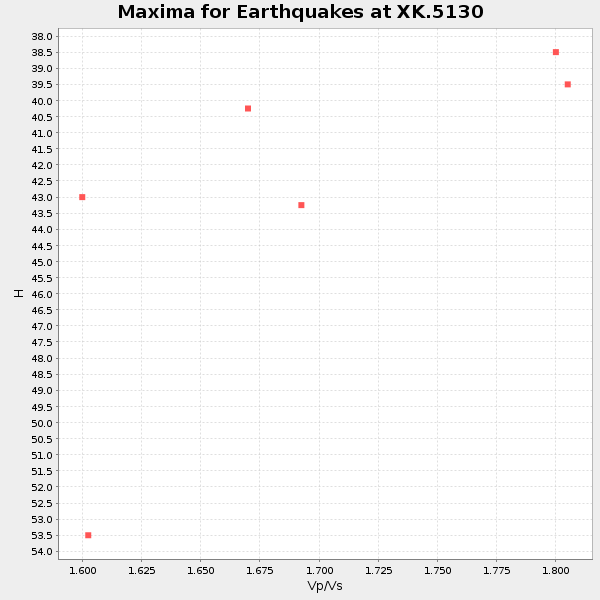
| Global Maxima | 42 km | 1.73 | 6.459 km/s | 3.728 km/s | 0.25 | amp=0.030493561 |
| Local Maxima 1 | 39 km | 1.85 | 6.459 km/s | 3.487 km/s | 0.29 | amp=0.019756278 |
| Local Maxima 2 | 52 km | 1.61 | 6.459 km/s | 4.012 km/s | 0.19 | amp=0.009150523 |
| Local Maxima 3 | 45 km | 1.61 | 6.459 km/s | 4.006 km/s | 0.19 | amp=0.0076726777 |
| Local Maxima 4 | 35 km | 2.06 | 6.459 km/s | 3.136 km/s | 0.35 | amp=0.007142538 |
| Predicted Arrivals for vertical incidence (zero ray parameter) | |
| Ps | 4.82 SECOND |
| PpPs | 17.98 SECOND |
| PsPs/PpSs | 22.80 SECOND |
Events Processed for this Station
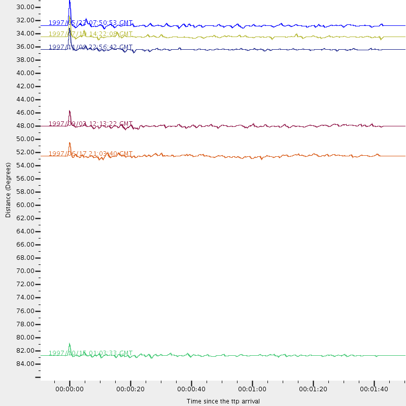
Download zip of receiver functions as SAC
Plot maxima for each earthquake.
Events Used in the Stack
(6 events)| Radial Match | Distance | Baz | FERegion | Time | Lat/Lon | Depth | Magnitude |
| 93.58167 | 34.5 deg | 192.862 deg | Near Coast Of Guerrero, Mexico | 1997/07/19 14:22:08 GMT | (16.3, -98.2) | 33 km | 5.7 MB, 6.3 MS, 6.8 UNKNOWN, 6.0 ME |
| 93.22538 | 82.8 deg | 163.233 deg | Near Coast Of Central Chile | 1997/10/15 01:03:33 GMT | (-30.9, -71.2) | 58 km | 6.8 MB, 6.8 MS, 7.3 UNKNOWN, 7.1 MW |
| 90.87485 | 36.4 deg | 176.949 deg | El Salvador | 1997/11/09 22:56:42 GMT | (13.8, -88.8) | 176 km | 5.6 MB, 6.4 UNKNOWN, 5.0 MD |
| 89.35969 | 52.6 deg | 307.872 deg | Andreanof Islands, Aleutian Is. | 1997/06/17 21:03:40 GMT | (51.3, -179.3) | 33 km | 6.4 MB, 6.3 MS, 6.4 UNKNOWN, 6.6 ML |
| 86.40573 | 32.8 deg | 199.386 deg | Guerrero, Mexico | 1997/05/22 07:50:53 GMT | (18.7, -101.6) | 70 km | 5.9 MB, 6.0 MS, 6.6 UNKNOWN, 6.5 MW |
| 81.713745 | 48.0 deg | 159.78 deg | Colombia | 1997/09/02 12:13:22 GMT | (3.8, -75.7) | 199 km | 6.5 MB, 6.8 UNKNOWN, 6.4 ME |
Losers
(14 events)| Radial Match | Distance | Baz | FERegion | Time | Lat/Lon | Depth | Magnitude | Reason |
| 77.32621 | 76.1 deg | 156.94 deg | Jujuy Province, Argentina | 1997/07/20 10:14:22 GMT | (-23.0, -66.3) | 256 km | 5.7 MB, 6.1 UNKNOWN, 5.7 ME | |
| 74.38084 | 82.2 deg | 163.689 deg | Near Coast Of Central Chile | 1997/07/27 05:21:29 GMT | (-30.5, -71.9) | 33 km | 5.6 MB, 5.8 MS, 6.3 UNKNOWN, 6.2 MW | |
| 69.9733 | 82.2 deg | 163.715 deg | Near Coast Of Central Chile | 1997/07/25 06:47:02 GMT | (-30.5, -71.9) | 33 km | 5.6 MB, 5.5 MS, 6.3 UNKNOWN | |
| 69.435265 | 75.4 deg | 51.472 deg | Central Mediterranean Sea | 1997/07/27 10:07:52 GMT | (35.6, 21.1) | 33 km | 5.5 MB, 4.8 MS, 5.6 UNKNOWN, 5.2 ML | |
| 66.87265 | 34.2 deg | 175.282 deg | Caribbean Sea | 1997/07/06 20:13:37 GMT | (16.2, -87.9) | 33 km | 5.5 MB, 5.5 MS, 6.0 UNKNOWN, 5.9 MW | |
| 64.409256 | 86.6 deg | 189.597 deg | Southern Pacific Ocean | 1997/05/29 17:02:38 GMT | (-36.0, -102.5) | 10 km | 5.6 MB, 6.1 MS, 6.5 UNKNOWN, 6.4 MW | |
| 64.20485 | 74.3 deg | 320.448 deg | Kuril Islands | 1997/07/14 16:09:35 GMT | (43.2, 146.4) | 33 km | 5.9 MB, 5.8 MS, 6.1 UNKNOWN, 5.8 ME | |
| 63.05491 | 81.8 deg | 163.602 deg | Near Coast Of Central Chile | 1997/07/06 09:54:00 GMT | (-30.1, -71.9) | 19 km | 5.8 MB, 6.5 MS, 6.8 UNKNOWN, 6.4 ME | |
| 59.939358 | 87.1 deg | 318.055 deg | Southeast Of Honshu, Japan | 1997/11/10 23:06:44 GMT | (31.2, 140.5) | 86 km | 5.8 MB, 6.1 UNKNOWN, 6.1 MW | |
| 59.569862 | 87.2 deg | 194.133 deg | Southern East Pacific Rise | 1997/06/10 21:53:55 GMT | (-35.8, -108.1) | 10 km | 5.8 MB, 6.1 MS, 6.5 UNKNOWN, 5.8 MS | |
| 54.804546 | 81.1 deg | 163.275 deg | Near Coast Of Central Chile | 1997/07/19 12:22:57 GMT | (-29.3, -71.7) | 26 km | 5.8 MB, 5.5 MS, 5.9 UNKNOWN, 5.8 MW | |
| 52.33363 | 74.4 deg | 321.628 deg | Hokkaido, Japan Region | 1997/11/15 07:05:16 GMT | (43.8, 145.0) | 161 km | 5.8 MB, 6.1 UNKNOWN, 6.1 MW | |
| 47.3197 | 92.4 deg | 312.633 deg | Volcano Islands, Japan Region | 1997/07/08 02:24:07 GMT | (23.8, 142.7) | 33 km | 5.8 MB, 5.6 MS, 5.9 UNKNOWN, 5.8 MW | |
| 34.776093 | 52.2 deg | 307.548 deg | Andreanof Islands, Aleutian Is. | 1997/07/08 12:11:15 GMT | (51.4, -178.6) | 33 km | 5.5 MB, 5.4 MS, 5.8 UNKNOWN, 5.6 ML |
