
Station XK 5150 - twist97_5150
Network: XK97 - Western Superior Teleseismic Experiment
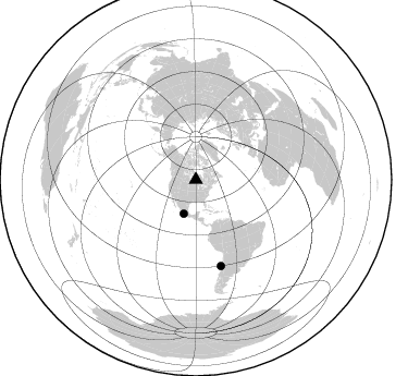
Nearby stations (2 deg radius)
| Station | Name | (Lat, Lon) | Start / End | Elevation |
| 5150 | twist97_5150 | (50.69, -90.56) | 1997-05-10 / 1997-12-31 | 367 m |
| Crust2 Type: | G1,Archean, no seds. |
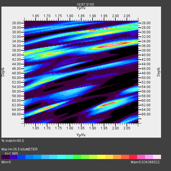
| Thickness Estimate: | 36 km |
| Thickness StdDev: | 3.8 km |
| Vp/Vs Estimate: | 1.99 |
| Vp/Vs StdDev: | 0.05 |
| Vs Estimate: | 3.254 km/s |
| Poisson's Ratio: | 0.33 |
| Peak Value: | 0.03 |
| Assumed Vp: | 6.459 km/s |
| Ps Weight: | 0.33333334 |
| PpPs Weight: | 0.33333334 |
| PsPs Weight: | 0.33333328 |
| Residual Complexity: | 0.841 |
| Nearby stations H: | +- |
| (2.0 deg) Vp/Vs: | +- |
2 with match > 90% ( 28.571428 %) and 2 with match > 80% ( 28.571428 %) out of 7.
Download stack as xyz text file.
Azimuth Distribution of Events:
Prior Results for this Station
| Study | Thickness | Vp/Vs | Vp | Vs | Poissons Ratio | Extra |
| EARS | 36 km | 1.99 | 6.459 km/s | 3.254 km/s | 0.33 | |
| Crust2.0 | 37 km | 1.76 | 6.459 km/s | 3.665 km/s | 0.26 | G1,Archean, no seds. |
| Global Maxima | 36 km | 1.99 | 6.459 km/s | 3.254 km/s | 0.33 | amp=0.034366522 |
| Local Maxima 1 | 28 km | 1.95 | 6.459 km/s | 3.308 km/s | 0.32 | amp=0.03326863 |
| Local Maxima 2 | 62 km | 1.97 | 6.459 km/s | 3.287 km/s | 0.33 | amp=0.031003945 |
| Local Maxima 3 | 63 km | 1.71 | 6.459 km/s | 3.789 km/s | 0.24 | amp=0.025587277 |
| Local Maxima 4 | 52 km | 1.66 | 6.459 km/s | 3.891 km/s | 0.22 | amp=0.023235708 |
| Predicted Arrivals for vertical incidence (zero ray parameter) | |
| Ps | 5.41 SECOND |
| PpPs | 16.41 SECOND |
| PsPs/PpSs | 21.82 SECOND |
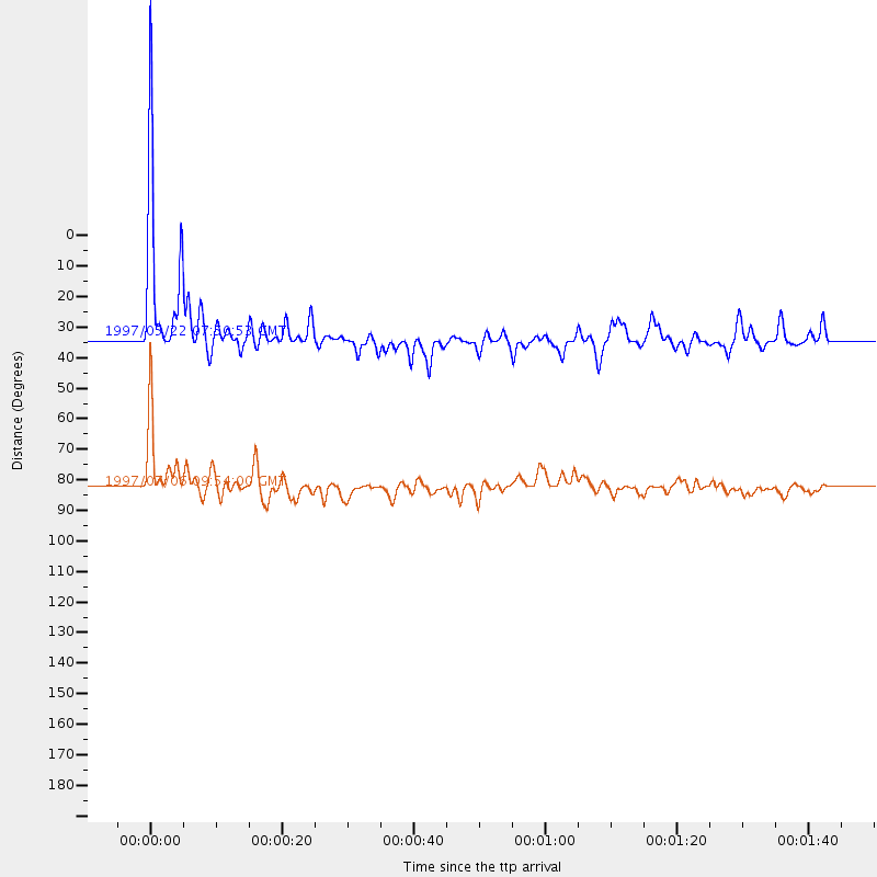
Events Processed for this Station
Download zip of receiver functions as SAC
Plot maxima for each earthquake.
Events Used in the Stack
(2 events)| Radial Match | Distance | Baz | FERegion | Time | Lat/Lon | Depth | Magnitude |
| 90.96622 | 33.1 deg | 199.415 deg | Guerrero, Mexico | 1997/05/22 07:50:53 GMT | (18.7, -101.6) | 70 km | 5.9 MB, 6.0 MS, 6.6 UNKNOWN, 6.5 MW |
| 90.10014 | 82.1 deg | 163.716 deg | Near Coast Of Central Chile | 1997/07/06 09:54:00 GMT | (-30.1, -71.9) | 19 km | 5.8 MB, 6.5 MS, 6.8 UNKNOWN, 6.4 ME |
Losers
(5 events)| Radial Match | Distance | Baz | FERegion | Time | Lat/Lon | Depth | Magnitude | Reason |
| 78.85385 | 91.7 deg | 14.838 deg | Hindu Kush Region, Afghanistan | 1997/05/13 14:13:45 GMT | (36.4, 70.9) | 196 km | 6.1 MB, 6.5 UNKNOWN, 6.4 MW | |
| 66.0299 | 74.1 deg | 320.462 deg | Kuril Islands | 1997/07/14 16:09:35 GMT | (43.2, 146.4) | 33 km | 5.9 MB, 5.8 MS, 6.1 UNKNOWN, 5.8 ME | |
| 60.291386 | 87.5 deg | 326.251 deg | Western Honshu, Japan | 1997/06/25 09:50:12 GMT | (34.4, 131.6) | 10 km | 5.5 MB, 5.6 MS, 5.9 UNKNOWN, 5.8 MW | |
| 57.667213 | 92.2 deg | 312.736 deg | Volcano Islands, Japan Region | 1997/07/08 02:24:07 GMT | (23.8, 142.7) | 33 km | 5.8 MB, 5.6 MS, 5.9 UNKNOWN, 5.8 MW | |
| 52.37631 | 87.5 deg | 194.224 deg | Southern East Pacific Rise | 1997/06/10 21:53:55 GMT | (-35.8, -108.1) | 10 km | 5.8 MB, 6.1 MS, 6.5 UNKNOWN, 5.8 MS |
