
Station XK 5170 - twist97_5170
Network: XK97 - Western Superior Teleseismic Experiment
Nearby stations (2 deg radius)
| Station | Name | (Lat, Lon) | Start / End | Elevation |
| 5170 | twist97_5170 | (51.03, -90.35) | 1997-05-12 / 1997-12-31 | 360 m |
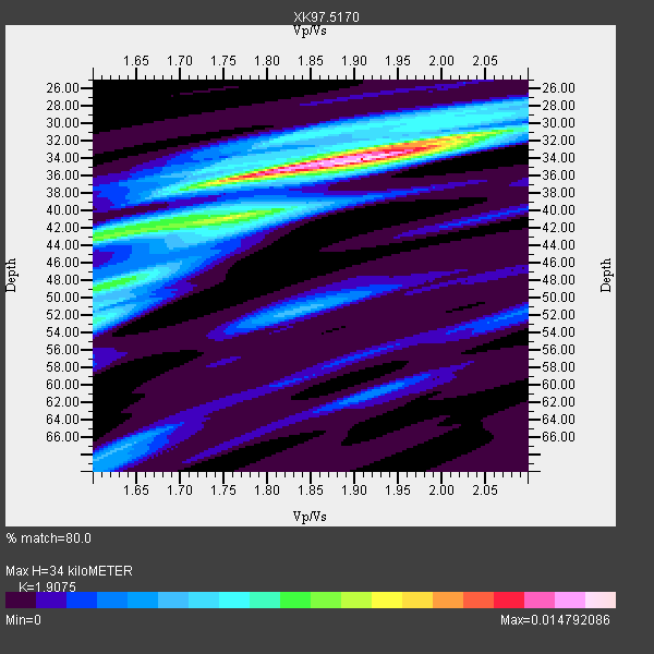
| Crust2 Type: | G1,Archean, no seds. |
| Thickness Estimate: | 34 km |
| Thickness StdDev: | 5.9 km |
| Vp/Vs Estimate: | 1.91 |
| Vp/Vs StdDev: | 0.11 |
| Vs Estimate: | 3.386 km/s |
| Poisson's Ratio: | 0.31 |
| Peak Value: | 0.01 |
| Assumed Vp: | 6.459 km/s |
| Ps Weight: | 0.33333334 |
| PpPs Weight: | 0.33333334 |
| PsPs Weight: | 0.33333328 |
| Residual Complexity: | 0.610 |
| Nearby stations H: | +- |
| (2.0 deg) Vp/Vs: | +- |
2 with match > 90% ( 10.526316 %) and 8 with match > 80% ( 42.105263 %) out of 19.
Download stack as xyz text file.
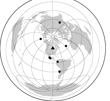
Azimuth Distribution of Events:
Prior Results for this Station
| Study | Thickness | Vp/Vs | Vp | Vs | Poissons Ratio | Extra |
| EARS | 34 km | 1.91 | 6.459 km/s | 3.386 km/s | 0.31 | |
| Crust2.0 | 37 km | 1.76 | 6.459 km/s | 3.665 km/s | 0.26 | G1,Archean, no seds. |
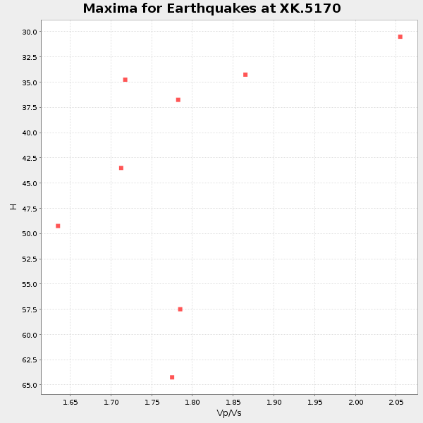
| Global Maxima | 34 km | 1.91 | 6.459 km/s | 3.386 km/s | 0.31 | amp=0.014792086 |
| Local Maxima 1 | 43 km | 1.62 | 6.459 km/s | 3.981 km/s | 0.19 | amp=0.007844564 |
| Local Maxima 2 | 32 km | 2.02 | 6.459 km/s | 3.202 km/s | 0.34 | amp=0.0073490636 |
| Local Maxima 3 | 48 km | 1.62 | 6.459 km/s | 3.981 km/s | 0.19 | amp=0.0065044216 |
| Local Maxima 4 | 36 km | 1.76 | 6.459 km/s | 3.675 km/s | 0.26 | amp=0.005935167 |
| Predicted Arrivals for vertical incidence (zero ray parameter) | |
| Ps | 4.78 SECOND |
| PpPs | 15.30 SECOND |
| PsPs/PpSs | 20.08 SECOND |
Events Processed for this Station
Download zip of receiver functions as SAC
Plot maxima for each earthquake.
Events Used in the Stack
(8 events)| Radial Match | Distance | Baz | FERegion | Time | Lat/Lon | Depth | Magnitude |
| 94.66796 | 35.2 deg | 193.18 deg | Near Coast Of Guerrero, Mexico | 1997/07/19 14:22:08 GMT | (16.3, -98.2) | 33 km | 5.7 MB, 6.3 MS, 6.8 UNKNOWN, 6.0 ME |
| 90.85657 | 52.3 deg | 307.616 deg | Andreanof Islands, Aleutian Is. | 1997/06/17 21:03:40 GMT | (51.3, -179.3) | 33 km | 6.4 MB, 6.3 MS, 6.4 UNKNOWN, 6.6 ML |
| 89.70647 | 45.6 deg | 80.376 deg | Azores Islands, Portugal | 1997/06/27 04:39:52 GMT | (38.3, -26.7) | 10 km | 5.6 MB, 5.4 MS, 5.9 UNKNOWN, 5.9 MW |
| 89.64476 | 82.4 deg | 163.904 deg | Near Coast Of Central Chile | 1997/07/06 09:54:00 GMT | (-30.1, -71.9) | 19 km | 5.8 MB, 6.5 MS, 6.8 UNKNOWN, 6.4 ME |
| 89.37364 | 48.6 deg | 160.405 deg | Colombia | 1997/09/02 12:13:22 GMT | (3.8, -75.7) | 199 km | 6.5 MB, 6.8 UNKNOWN, 6.4 ME |
| 89.244415 | 33.5 deg | 199.587 deg | Guerrero, Mexico | 1997/05/22 07:50:53 GMT | (18.7, -101.6) | 70 km | 5.9 MB, 6.0 MS, 6.6 UNKNOWN, 6.5 MW |
| 87.17238 | 82.8 deg | 163.989 deg | Near Coast Of Central Chile | 1997/07/27 05:21:29 GMT | (-30.5, -71.9) | 33 km | 5.6 MB, 5.8 MS, 6.3 UNKNOWN, 6.2 MW |
| 82.84827 | 91.4 deg | 14.997 deg | Hindu Kush Region, Afghanistan | 1997/05/13 14:13:45 GMT | (36.4, 70.9) | 196 km | 6.1 MB, 6.5 UNKNOWN, 6.4 MW |
Losers
(11 events)| Radial Match | Distance | Baz | FERegion | Time | Lat/Lon | Depth | Magnitude | Reason |
| 78.26195 | 87.3 deg | 189.851 deg | Southern Pacific Ocean | 1997/05/29 17:02:38 GMT | (-36.0, -102.5) | 10 km | 5.6 MB, 6.1 MS, 6.5 UNKNOWN, 6.4 MW | |
| 76.01047 | 74.0 deg | 320.53 deg | Kuril Islands | 1997/07/14 16:09:35 GMT | (43.2, 146.4) | 33 km | 5.9 MB, 5.8 MS, 6.1 UNKNOWN, 5.8 ME | |
| 72.305405 | 82.8 deg | 164.015 deg | Near Coast Of Central Chile | 1997/07/25 06:47:02 GMT | (-30.5, -71.9) | 33 km | 5.6 MB, 5.5 MS, 6.3 UNKNOWN | |
| 71.31337 | 76.7 deg | 157.297 deg | Jujuy Province, Argentina | 1997/07/20 10:14:22 GMT | (-23.0, -66.3) | 256 km | 5.7 MB, 6.1 UNKNOWN, 5.7 ME | |
| 65.289894 | 74.9 deg | 51.828 deg | Central Mediterranean Sea | 1997/07/27 10:07:52 GMT | (35.6, 21.1) | 33 km | 5.5 MB, 4.8 MS, 5.6 UNKNOWN, 5.2 ML | |
| 58.935894 | 81.6 deg | 163.584 deg | Near Coast Of Central Chile | 1997/07/19 12:22:57 GMT | (-29.3, -71.7) | 26 km | 5.8 MB, 5.5 MS, 5.9 UNKNOWN, 5.8 MW | |
| 57.487362 | 92.1 deg | 312.907 deg | Volcano Islands, Japan Region | 1997/07/08 02:24:07 GMT | (23.8, 142.7) | 33 km | 5.8 MB, 5.6 MS, 5.9 UNKNOWN, 5.8 MW | |
| 55.559364 | 87.9 deg | 194.384 deg | Southern East Pacific Rise | 1997/06/10 21:53:55 GMT | (-35.8, -108.1) | 10 km | 5.8 MB, 6.1 MS, 6.5 UNKNOWN, 5.8 MS | |
| 51.713276 | 75.6 deg | 159.124 deg | Northern Chile | 1997/09/28 23:13:13 GMT | (-22.4, -68.4) | 107 km | 5.7 MB, 5.6 UNKNOWN, 5.6 MW | |
| 42.551712 | 93.3 deg | 312.151 deg | Volcano Islands, Japan Region | 1997/07/28 06:46:55 GMT | (22.4, 142.7) | 33 km | 5.7 MB, 5.8 MS, 5.9 UNKNOWN, 5.9 MW | |
| 6.8560505 | 85.4 deg | 317.619 deg | Southeast Of Honshu, Japan | 1997/09/30 06:27:24 GMT | (32.0, 141.9) | 10 km | 5.5 MB, 6.5 MS, 6.1 UNKNOWN, 6.0 MW |
