
Station XK 5190 - twist97_5190
Network: XK97 - Western Superior Teleseismic Experiment
Nearby stations (2 deg radius)
| Station | Name | (Lat, Lon) | Start / End | Elevation |
| 5190 | twist97_5190 | (51.35, -90.22) | 1997-06-24 / 1997-12-31 | 400 m |
| Crust2 Type: | G1,Archean, no seds. |
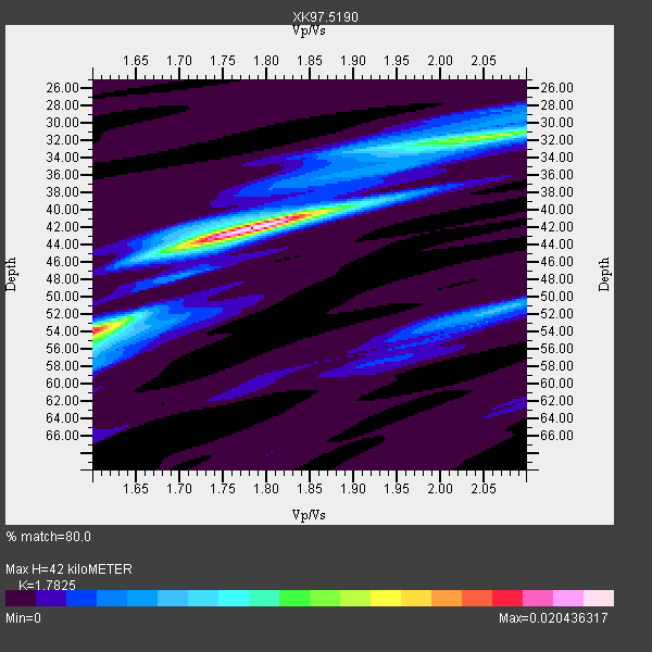
| Thickness Estimate: | 42 km |
| Thickness StdDev: | 6.2 km |
| Vp/Vs Estimate: | 1.78 |
| Vp/Vs StdDev: | 0.12 |
| Vs Estimate: | 3.624 km/s |
| Poisson's Ratio: | 0.27 |
| Peak Value: | 0.02 |
| Assumed Vp: | 6.459 km/s |
| Ps Weight: | 0.33333334 |
| PpPs Weight: | 0.33333334 |
| PsPs Weight: | 0.33333328 |
| Residual Complexity: | 0.596 |
| Nearby stations H: | +- |
| (2.0 deg) Vp/Vs: | +- |
5 with match > 90% ( 29.411764 %) and 7 with match > 80% ( 41.17647 %) out of 17.
Download stack as xyz text file.
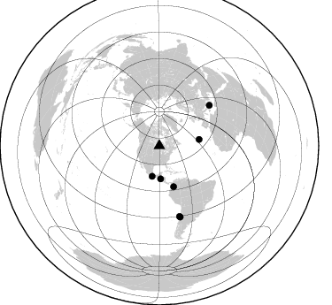
Azimuth Distribution of Events:
Prior Results for this Station
| Study | Thickness | Vp/Vs | Vp | Vs | Poissons Ratio | Extra |
| EARS | 42 km | 1.78 | 6.459 km/s | 3.624 km/s | 0.27 | |
| Crust2.0 | 37 km | 1.76 | 6.459 km/s | 3.665 km/s | 0.26 | G1,Archean, no seds. |
| Global Maxima | 42 km | 1.78 | 6.459 km/s | 3.624 km/s | 0.27 | amp=0.020436317 |
| Local Maxima 1 | 54 km | 1.60 | 6.459 km/s | 4.037 km/s | 0.18 | amp=0.016118256 |
| Local Maxima 2 | 31 km | 2.08 | 6.459 km/s | 3.109 km/s | 0.35 | amp=0.007998066 |
| Local Maxima 3 | 51 km | 2.07 | 6.459 km/s | 3.121 km/s | 0.35 | amp=0.005753067 |
| Local Maxima 4 | 45 km | 1.69 | 6.459 km/s | 3.834 km/s | 0.23 | amp=0.0038512652 |
| Predicted Arrivals for vertical incidence (zero ray parameter) | |
| Ps | 5.09 SECOND |
| PpPs | 18.09 SECOND |
| PsPs/PpSs | 23.18 SECOND |
Events Processed for this Station
Download zip of receiver functions as SAC
Plot maxima for each earthquake.
Events Used in the Stack
(7 events)| Radial Match | Distance | Baz | FERegion | Time | Lat/Lon | Depth | Magnitude |
| 97.42606 | 37.4 deg | 177.739 deg | El Salvador | 1997/11/09 22:56:42 GMT | (13.8, -88.8) | 176 km | 5.6 MB, 6.4 UNKNOWN, 5.0 MD |
| 95.49698 | 83.6 deg | 163.648 deg | Near Coast Of Central Chile | 1997/10/15 01:03:33 GMT | (-30.9, -71.2) | 58 km | 6.8 MB, 6.8 MS, 7.3 UNKNOWN, 7.1 MW |
| 94.562904 | 35.5 deg | 193.288 deg | Near Coast Of Guerrero, Mexico | 1997/07/19 14:22:08 GMT | (16.3, -98.2) | 33 km | 5.7 MB, 6.3 MS, 6.8 UNKNOWN, 6.0 ME |
| 91.63375 | 72.8 deg | 50.994 deg | Ionian Sea | 1997/11/18 13:07:41 GMT | (37.6, 20.7) | 33 km | 5.9 MB, 6.4 MS, 6.7 UNKNOWN, 6.1 ML |
| 91.5903 | 48.9 deg | 160.666 deg | Colombia | 1997/09/02 12:13:22 GMT | (3.8, -75.7) | 199 km | 6.5 MB, 6.8 UNKNOWN, 6.4 ME |
| 86.04075 | 45.5 deg | 80.773 deg | Azores Islands, Portugal | 1997/06/27 04:39:52 GMT | (38.3, -26.7) | 10 km | 5.6 MB, 5.4 MS, 5.9 UNKNOWN, 5.9 MW |
| 84.02218 | 82.7 deg | 164.026 deg | Near Coast Of Central Chile | 1997/07/06 09:54:00 GMT | (-30.1, -71.9) | 19 km | 5.8 MB, 6.5 MS, 6.8 UNKNOWN, 6.4 ME |
Losers
(10 events)| Radial Match | Distance | Baz | FERegion | Time | Lat/Lon | Depth | Magnitude | Reason |
| 73.81723 | 83.0 deg | 164.136 deg | Near Coast Of Central Chile | 1997/07/25 06:47:02 GMT | (-30.5, -71.9) | 33 km | 5.6 MB, 5.5 MS, 6.3 UNKNOWN | |
| 69.11579 | 76.9 deg | 157.444 deg | Jujuy Province, Argentina | 1997/07/20 10:14:22 GMT | (-23.0, -66.3) | 256 km | 5.7 MB, 6.1 UNKNOWN, 5.7 ME | |
| 68.307396 | 86.5 deg | 318.355 deg | Southeast Of Honshu, Japan | 1997/11/10 23:06:44 GMT | (31.2, 140.5) | 86 km | 5.8 MB, 6.1 UNKNOWN, 6.1 MW | |
| 63.88939 | 91.0 deg | 24.806 deg | Northern And Central Iran | 1997/06/25 19:38:40 GMT | (33.9, 59.5) | 10 km | 5.5 MB, 5.8 MS, 6.0 UNKNOWN, 5.9 MW | |
| 61.03058 | 73.8 deg | 321.738 deg | Hokkaido, Japan Region | 1997/11/15 07:05:16 GMT | (43.8, 145.0) | 161 km | 5.8 MB, 6.1 UNKNOWN, 6.1 MW | |
| 59.736008 | 73.8 deg | 320.553 deg | Kuril Islands | 1997/07/14 16:09:35 GMT | (43.2, 146.4) | 33 km | 5.9 MB, 5.8 MS, 6.1 UNKNOWN, 5.8 ME | |
| 54.59564 | 73.2 deg | 51.034 deg | Ionian Sea | 1997/11/18 13:13:46 GMT | (37.3, 20.9) | 33 km | 5.5 ML, 5.4 MB | |
| 54.501247 | 75.9 deg | 159.272 deg | Northern Chile | 1997/09/28 23:13:13 GMT | (-22.4, -68.4) | 107 km | 5.7 MB, 5.6 UNKNOWN, 5.6 MW | |
| 54.190815 | 83.4 deg | 163.713 deg | Near Coast Of Central Chile | 1997/11/03 20:12:52 GMT | (-30.8, -71.3) | 45 km | 5.6 MB, 5.2 MD | |
| 48.308453 | 91.9 deg | 313.017 deg | Volcano Islands, Japan Region | 1997/07/08 02:24:07 GMT | (23.8, 142.7) | 33 km | 5.8 MB, 5.6 MS, 5.9 UNKNOWN, 5.8 MW |
