
Station XK N01 - North 01
Network: XK99 - CDROM (Colorado)
Nearby stations (2 deg radius)
| Station | Name | (Lat, Lon) | Start / End | Elevation |
| N01 | North 01 | (42.28, -107.60) | 1999-06-09 / 2000-12-31 | 2275 m |
| Crust2 Type: | PH,orogen/46km, Orogen, 3.5 km seds. |
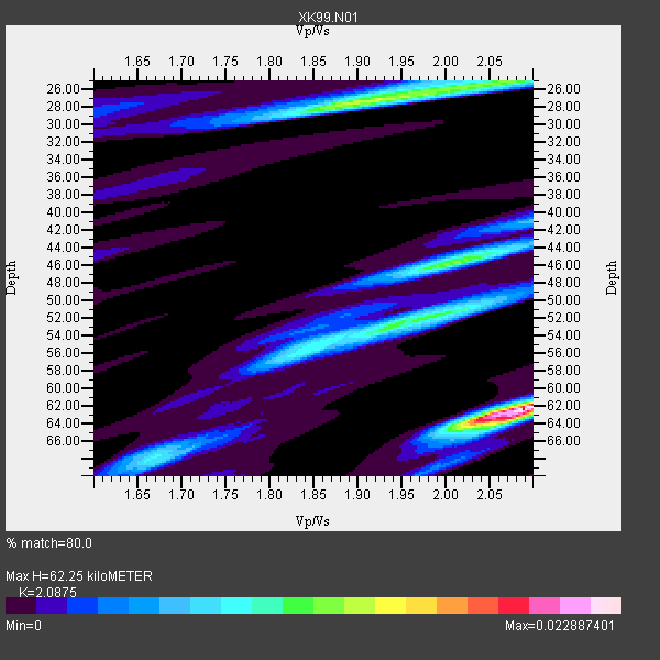
| Thickness Estimate: | 62 km |
| Thickness StdDev: | 14 km |
| Vp/Vs Estimate: | 2.09 |
| Vp/Vs StdDev: | 0.14 |
| Vs Estimate: | 2.96 km/s |
| Poisson's Ratio: | 0.35 |
| Peak Value: | 0.02 |
| Assumed Vp: | 6.178 km/s |
| Ps Weight: | 0.33333334 |
| PpPs Weight: | 0.33333334 |
| PsPs Weight: | 0.33333328 |
| Residual Complexity: | 0.827 |
| Nearby stations H: | +- |
| (2.0 deg) Vp/Vs: | +- |
2 with match > 90% ( 18.181818 %) and 11 with match > 80% ( 100.0 %) out of 11.
Download stack as xyz text file.
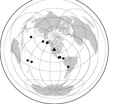
Azimuth Distribution of Events:
Prior Results for this Station
| Study | Thickness | Vp/Vs | Vp | Vs | Poissons Ratio | Extra |
| EARS | 62 km | 2.09 | 6.178 km/s | 2.96 km/s | 0.35 | |
| Crust2.0 | 46 km | 1.77 | 6.178 km/s | 3.498 km/s | 0.26 | PH,orogen/46km, Orogen, 3.5 km seds. |
| Global Maxima | 62 km | 2.09 | 6.178 km/s | 2.96 km/s | 0.35 | amp=0.022887401 |
| Local Maxima 1 | 27 km | 1.92 | 6.178 km/s | 3.209 km/s | 0.32 | amp=0.013754257 |
| Local Maxima 2 | 46 km | 2.00 | 6.178 km/s | 3.089 km/s | 0.33 | amp=0.011843887 |
| Local Maxima 3 | 53 km | 1.94 | 6.178 km/s | 3.185 km/s | 0.32 | amp=0.0108761145 |
| Local Maxima 4 | 68 km | 1.67 | 6.178 km/s | 3.705 km/s | 0.22 | amp=0.008212908 |
| Predicted Arrivals for vertical incidence (zero ray parameter) | |
| Ps | 10.96 SECOND |
| PpPs | 31.11 SECOND |
| PsPs/PpSs | 42.07 SECOND |
Events Processed for this Station
Download zip of receiver functions as SAC
Plot maxima for each earthquake.
Events Used in the Stack
(11 events)| Radial Match | Distance | Baz | FERegion | Time | Lat/Lon | Depth | Magnitude |
| 95.09203 | 88.1 deg | 298.643 deg | Volcano Islands, Japan Region | 2000/03/28 11:00:22 GMT | (22.3, 143.7) | 126 km | 6.8 MB, 7.6 MS, 7.6 MW, 7.6 MW |
| 90.82868 | 30.2 deg | 149.83 deg | Near Coast Of Chiapas, Mexico | 2000/03/12 22:21:30 GMT | (15.0, -92.4) | 62 km | 5.5 MB, 5.8 MS, 6.3 MW, 5.4 MD |
| 88.87256 | 85.0 deg | 241.909 deg | Tonga Islands | 2000/01/08 16:47:20 GMT | (-16.9, -174.2) | 183 km | 6.5 MB, 6.6 MS, 7.2 MW, 7.0 ME |
| 87.655846 | 46.2 deg | 306.273 deg | Andreanof Islands, Aleutian Is. | 1999/08/01 12:47:50 GMT | (51.5, -176.3) | 33 km | 5.5 MB, 5.5 MS, 5.8 MW, 5.8 MW |
| 87.17415 | 73.1 deg | 140.783 deg | Southern Bolivia | 1999/09/15 03:01:24 GMT | (-20.9, -67.3) | 218 km | 6.0 MB, 6.4 MW, 6.4 MW |
| 85.16537 | 33.1 deg | 313.501 deg | Kodiak Island Region, Alaska | 1999/12/07 00:19:49 GMT | (57.4, -154.5) | 41 km | 6.5 MB, 6.1 MS, 6.4 MW, 6.3 ML |
| 84.06837 | 33.1 deg | 313.597 deg | Kodiak Island Region, Alaska | 1999/12/06 23:12:33 GMT | (57.4, -154.5) | 66 km | 6.8 MB, 7.0 MW, 7.0 ML |
| 83.99772 | 31.2 deg | 142.128 deg | Honduras | 1999/07/11 14:14:16 GMT | (15.8, -88.3) | 10 km | 6.0 MB, 6.6 MS, 6.7 MW, 6.3 ME |
| 82.59581 | 94.8 deg | 248.094 deg | Vanuatu Islands Region | 2000/02/25 01:43:58 GMT | (-19.5, 173.8) | 33 km | 6.1 MB, 7.1 MS, 7.1 MW, 7.0 MW |
| 82.53677 | 41.5 deg | 133.665 deg | Panama | 2000/02/26 18:24:39 GMT | (9.4, -78.5) | 65 km | 5.8 MB, 5.4 MS, 6.2 MW, 6.1 MW |
| 80.0495 | 32.6 deg | 317.071 deg | Southern Alaska | 2000/05/19 20:34:26 GMT | (59.2, -153.1) | 80 km | 5.6 MB, 5.9 MW, 5.9 MW |
Losers
(0 events)| Radial Match | Distance | Baz | FERegion | Time | Lat/Lon | Depth | Magnitude | Reason |
