
Station XK N05 - North 05
Network: XK99 - CDROM (Colorado)
Nearby stations (2 deg radius)

| Station | Name | (Lat, Lon) | Start / End | Elevation |
| N05 | North 05 | (41.89, -107.39) | 1999-06-07 / 2000-12-31 | 2077 m |
| Crust2 Type: | P1,orogen/46km, Urals, Tethian Orogen, 2 km seds. |
| Thickness Estimate: | 52 km |
| Thickness StdDev: | 6.9 km |
| Vp/Vs Estimate: | 1.71 |
| Vp/Vs StdDev: | 0.12 |
| Vs Estimate: | 3.596 km/s |
| Poisson's Ratio: | 0.24 |
| Peak Value: | 0.01 |
| Assumed Vp: | 6.159 km/s |
| Ps Weight: | 0.33333334 |
| PpPs Weight: | 0.33333334 |
| PsPs Weight: | 0.33333328 |
| Residual Complexity: | 0.791 |
| Nearby stations H: | +- |
| (2.0 deg) Vp/Vs: | +- |
4 with match > 90% ( 36.363636 %) and 11 with match > 80% ( 100.0 %) out of 11.
Download stack as xyz text file.
Azimuth Distribution of Events:

Prior Results for this Station
| Study | Thickness | Vp/Vs | Vp | Vs | Poissons Ratio | Extra |
| EARS | 52 km | 1.71 | 6.159 km/s | 3.596 km/s | 0.24 | |
| Crust2.0 | 46 km | 1.76 | 6.159 km/s | 3.507 km/s | 0.26 | P1,orogen/46km, Urals, Tethian Orogen, 2 km seds. |
| Global Maxima | 52 km | 1.71 | 6.159 km/s | 3.596 km/s | 0.24 | amp=0.0137273185 |
| Local Maxima 1 | 35 km | 2.09 | 6.159 km/s | 2.947 km/s | 0.35 | amp=0.009381112 |
| Local Maxima 2 | 42 km | 1.75 | 6.159 km/s | 3.514 km/s | 0.26 | amp=0.0073022717 |
| Local Maxima 3 | 42 km | 1.89 | 6.159 km/s | 3.254 km/s | 0.31 | amp=0.00674548 |
| Local Maxima 4 | 66 km | 1.60 | 6.159 km/s | 3.849 km/s | 0.18 | amp=0.0046504783 |
| Predicted Arrivals for vertical incidence (zero ray parameter) | |
| Ps | 6.02 SECOND |
| PpPs | 22.90 SECOND |
| PsPs/PpSs | 28.92 SECOND |
Events Processed for this Station
Download zip of receiver functions as SAC
Plot maxima for each earthquake.
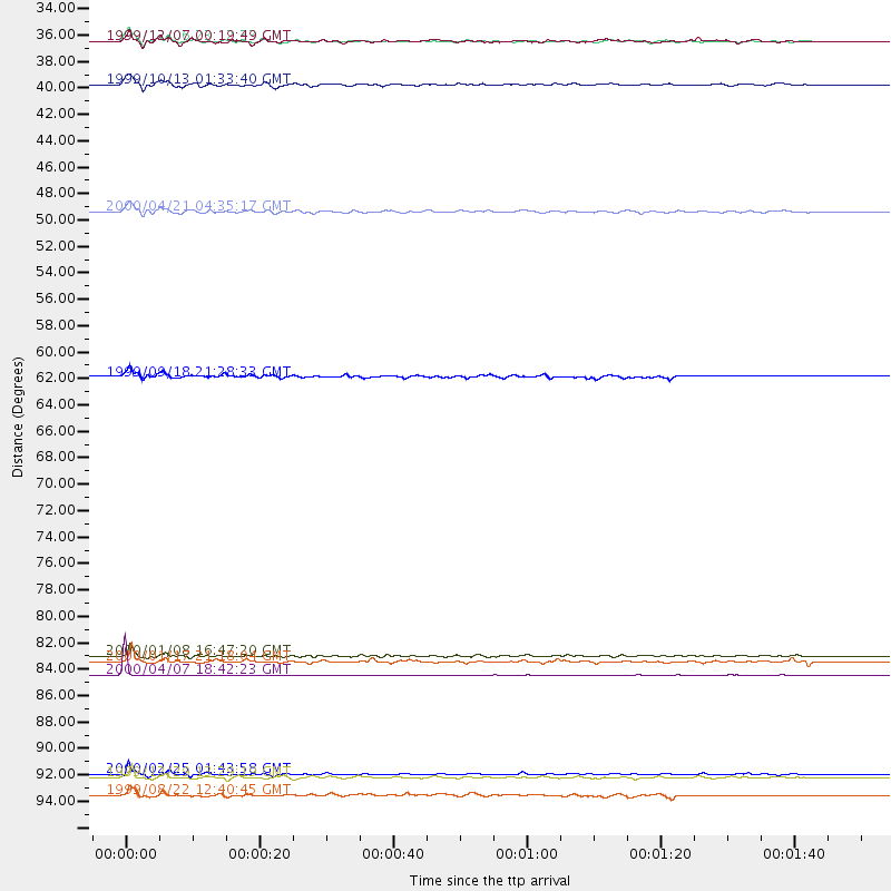
Events Used in the Stack
(11 events)| Radial Match | Distance | Baz | FERegion | Time | Lat/Lon | Depth | Magnitude |
| 99.25291 | 86.6 deg | 241.866 deg | Tonga Islands | 2000/04/07 18:42:23 GMT | (-18.3, -175.3) | 208 km | 5.4 MB, 5.8 MW, 5.8 MW |
| 93.06917 | 33.4 deg | 313.997 deg | Kodiak Island Region, Alaska | 1999/12/06 23:12:33 GMT | (57.4, -154.5) | 66 km | 6.8 MB, 7.0 MW, 7.0 ML |
| 91.29635 | 95.1 deg | 260.11 deg | Santa Cruz Islands | 1999/12/29 13:29:19 GMT | (-10.9, 165.4) | 33 km | 5.6 MB, 6.8 MS, 6.8 MW, 6.3 MW |
| 90.35583 | 94.8 deg | 248.199 deg | Vanuatu Islands Region | 2000/02/25 01:43:58 GMT | (-19.5, 173.8) | 33 km | 6.1 MB, 7.1 MS, 7.1 MW, 7.0 MW |
| 88.71615 | 33.4 deg | 313.902 deg | Kodiak Island Region, Alaska | 1999/12/07 00:19:49 GMT | (57.4, -154.5) | 41 km | 6.5 MB, 6.1 MS, 6.4 MW, 6.3 ML |
| 87.91529 | 37.1 deg | 308.972 deg | Alaska Peninsula | 1999/10/13 01:33:40 GMT | (54.7, -161.2) | 30 km | 6.0 MB, 6.2 MS, 6.5 MW, 6.0 ML |
| 87.398796 | 47.7 deg | 306.958 deg | Andreanof Islands, Aleutian Is. | 2000/04/21 04:35:17 GMT | (51.4, -178.1) | 33 km | 6.0 MB, 5.7 MS, 6.2 ML, 6.0 MW |
| 86.7698 | 96.6 deg | 254.437 deg | Vanuatu Islands | 1999/08/22 12:40:45 GMT | (-16.1, 168.0) | 33 km | 6.3 MB, 6.2 MS, 6.5 MW, 6.5 MW |
| 86.00481 | 85.5 deg | 246.084 deg | Fiji Islands Region | 2000/01/17 21:18:04 GMT | (-14.5, -177.6) | 33 km | 5.6 MB, 5.7 MS, 5.9 MW, 5.8 MW |
| 84.94079 | 61.6 deg | 314.567 deg | Near East Coast Of Kamchatka | 1999/09/18 21:28:33 GMT | (51.2, 157.6) | 60 km | 5.9 MB, 5.6 MS, 6.2 MW, 6.0 MW |
| 83.72664 | 84.9 deg | 242.086 deg | Tonga Islands | 2000/01/08 16:47:20 GMT | (-16.9, -174.2) | 183 km | 6.5 MB, 6.6 MS, 7.2 MW, 7.0 ME |
Losers
(0 events)| Radial Match | Distance | Baz | FERegion | Time | Lat/Lon | Depth | Magnitude | Reason |
