
Station XK N09 - North 09
Network: XK99 - CDROM (Colorado)
Nearby stations (2 deg radius)

| Station | Name | (Lat, Lon) | Start / End | Elevation |
| N09 | North 09 | (41.54, -107.24) | 1999-06-07 / 2000-12-31 | 2147 m |
| Crust2 Type: | P1,orogen/46km, Urals, Tethian Orogen, 2 km seds. |
| Thickness Estimate: | 29 km |
| Thickness StdDev: | 8.0 km |
| Vp/Vs Estimate: | 1.68 |
| Vp/Vs StdDev: | 0.09 |
| Vs Estimate: | 3.66 km/s |
| Poisson's Ratio: | 0.23 |
| Peak Value: | 0.01 |
| Assumed Vp: | 6.159 km/s |
| Ps Weight: | 0.33333334 |
| PpPs Weight: | 0.33333334 |
| PsPs Weight: | 0.33333328 |
| Residual Complexity: | 0.787 |
| Nearby stations H: | +- |
| (2.0 deg) Vp/Vs: | +- |
7 with match > 90% ( 53.846153 %) and 13 with match > 80% ( 100.0 %) out of 13.
Download stack as xyz text file.
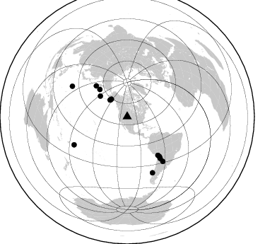
Azimuth Distribution of Events:
Prior Results for this Station
| Study | Thickness | Vp/Vs | Vp | Vs | Poissons Ratio | Extra |
| EARS | 29 km | 1.68 | 6.159 km/s | 3.66 km/s | 0.23 | |
| Crust2.0 | 46 km | 1.76 | 6.159 km/s | 3.507 km/s | 0.26 | P1,orogen/46km, Urals, Tethian Orogen, 2 km seds. |
| Global Maxima | 29 km | 1.68 | 6.159 km/s | 3.66 km/s | 0.23 | amp=0.008918514 |
| Local Maxima 1 | 32 km | 1.82 | 6.159 km/s | 3.384 km/s | 0.28 | amp=0.008435225 |
| Local Maxima 2 | 48 km | 1.64 | 6.159 km/s | 3.744 km/s | 0.21 | amp=0.006583266 |
| Local Maxima 3 | 25 km | 1.93 | 6.159 km/s | 3.195 km/s | 0.32 | amp=0.0057776654 |
| Local Maxima 4 | 50 km | 1.60 | 6.159 km/s | 3.849 km/s | 0.18 | amp=0.0046450812 |
| Predicted Arrivals for vertical incidence (zero ray parameter) | |
| Ps | 3.19 SECOND |
| PpPs | 12.52 SECOND |
| PsPs/PpSs | 15.71 SECOND |
Events Processed for this Station
Download zip of receiver functions as SAC
Plot maxima for each earthquake.
Events Used in the Stack
(13 events)| Radial Match | Distance | Baz | FERegion | Time | Lat/Lon | Depth | Magnitude |
| 96.73759 | 88.7 deg | 298.895 deg | Volcano Islands, Japan Region | 2000/03/28 11:00:22 GMT | (22.3, 143.7) | 126 km | 6.8 MB, 7.6 MS, 7.6 MW, 7.6 MW |
| 96.093544 | 75.0 deg | 141.629 deg | Jujuy Province, Argentina | 2000/05/12 18:43:18 GMT | (-23.5, -66.5) | 225 km | 6.2 MB, 7.2 MW, 7.1 MW |
| 95.996956 | 80.7 deg | 141.42 deg | Santiago Del Estero Prov., Arg. | 2000/04/23 09:27:23 GMT | (-28.3, -63.0) | 608 km | 6.6 MB, 7.0 MW, 7.0 MW |
| 95.09916 | 33.8 deg | 314.359 deg | Kodiak Island Region, Alaska | 1999/12/06 23:12:33 GMT | (57.4, -154.5) | 66 km | 6.8 MB, 7.0 MW, 7.0 ML |
| 93.245865 | 84.9 deg | 242.216 deg | Tonga Islands | 2000/01/08 16:47:20 GMT | (-16.9, -174.2) | 183 km | 6.5 MB, 6.6 MS, 7.2 MW, 7.0 ME |
| 91.53035 | 72.4 deg | 140.94 deg | Southern Bolivia | 1999/09/15 03:01:24 GMT | (-20.9, -67.3) | 218 km | 6.0 MB, 6.4 MW, 6.4 MW |
| 90.35642 | 33.8 deg | 314.265 deg | Kodiak Island Region, Alaska | 1999/12/07 00:19:49 GMT | (57.4, -154.5) | 41 km | 6.5 MB, 6.1 MS, 6.4 MW, 6.3 ML |
| 88.54686 | 86.8 deg | 155.785 deg | Off Coast Of Southern Chile | 1999/08/22 09:35:39 GMT | (-40.5, -74.8) | 33 km | 6.2 MB, 5.8 MS, 6.4 MW, 6.2 MW |
| 87.50744 | 48.0 deg | 307.25 deg | Andreanof Islands, Aleutian Is. | 2000/04/21 04:35:17 GMT | (51.4, -178.1) | 33 km | 6.0 MB, 5.7 MS, 6.2 ML, 6.0 MW |
| 86.59896 | 54.6 deg | 314.712 deg | Komandorskiye Ostrova Region | 1999/09/28 05:00:42 GMT | (54.6, 168.3) | 33 km | 5.4 MB, 6.1 MS, 6.1 MW, 6.1 MW |
| 83.95237 | 69.7 deg | 141.505 deg | Northern Chile | 1999/11/30 04:01:53 GMT | (-18.9, -69.2) | 128 km | 6.2 MB, 6.6 MW, 6.5 MW |
| 81.61115 | 61.9 deg | 314.758 deg | Near East Coast Of Kamchatka | 1999/09/18 21:28:33 GMT | (51.2, 157.6) | 60 km | 5.9 MB, 5.6 MS, 6.2 MW, 6.0 MW |
| 80.1578 | 33.3 deg | 317.775 deg | Southern Alaska | 2000/05/19 20:34:26 GMT | (59.2, -153.1) | 80 km | 5.6 MB, 5.9 MW, 5.9 MW |
Losers
(0 events)| Radial Match | Distance | Baz | FERegion | Time | Lat/Lon | Depth | Magnitude | Reason |
