
Station XK N10 - North 10
Network: XK99 - CDROM (Colorado)
Nearby stations (2 deg radius)
| Station | Name | (Lat, Lon) | Start / End | Elevation |
| N10 | North 10 | (41.45, -107.21) | 1999-06-07 / 2000-12-31 | 2240 m |
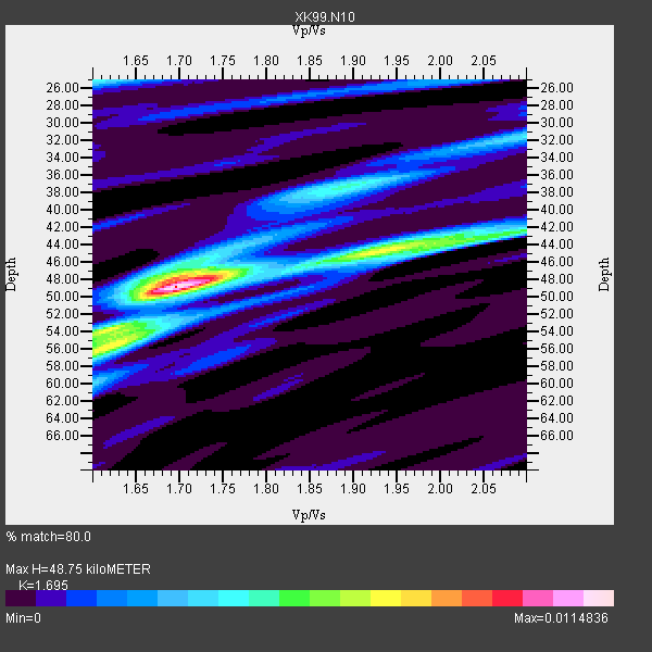
| Crust2 Type: | P1,orogen/46km, Urals, Tethian Orogen, 2 km seds. |
| Thickness Estimate: | 49 km |
| Thickness StdDev: | 6.2 km |
| Vp/Vs Estimate: | 1.70 |
| Vp/Vs StdDev: | 0.12 |
| Vs Estimate: | 3.633 km/s |
| Poisson's Ratio: | 0.23 |
| Peak Value: | 0.01 |
| Assumed Vp: | 6.159 km/s |
| Ps Weight: | 0.33333334 |
| PpPs Weight: | 0.33333334 |
| PsPs Weight: | 0.33333328 |
| Residual Complexity: | 0.584 |
| Nearby stations H: | +- |
| (2.0 deg) Vp/Vs: | +- |
8 with match > 90% ( 44.444443 %) and 18 with match > 80% ( 100.0 %) out of 18.
Download stack as xyz text file.
Azimuth Distribution of Events:

Prior Results for this Station
| Study | Thickness | Vp/Vs | Vp | Vs | Poissons Ratio | Extra |
| EARS | 49 km | 1.70 | 6.159 km/s | 3.633 km/s | 0.23 | |
| Crust2.0 | 46 km | 1.76 | 6.159 km/s | 3.507 km/s | 0.26 | P1,orogen/46km, Urals, Tethian Orogen, 2 km seds. |
| Global Maxima | 49 km | 1.70 | 6.159 km/s | 3.633 km/s | 0.23 | amp=0.0114836 |
| Local Maxima 1 | 54 km | 1.61 | 6.159 km/s | 3.825 km/s | 0.19 | amp=0.0057604844 |
| Local Maxima 2 | 44 km | 1.95 | 6.159 km/s | 3.166 km/s | 0.32 | amp=0.005001544 |
| Local Maxima 3 | 37 km | 1.89 | 6.159 km/s | 3.263 km/s | 0.30 | amp=0.0045028734 |
| Local Maxima 4 | 25 km | 1.61 | 6.159 km/s | 3.837 km/s | 0.18 | amp=0.004102096 |
| Predicted Arrivals for vertical incidence (zero ray parameter) | |
| Ps | 5.50 SECOND |
| PpPs | 21.33 SECOND |
| PsPs/PpSs | 26.83 SECOND |
Events Processed for this Station
Download zip of receiver functions as SAC
Plot maxima for each earthquake.
Events Used in the Stack
(18 events)| Radial Match | Distance | Baz | FERegion | Time | Lat/Lon | Depth | Magnitude |
| 98.10895 | 88.7 deg | 298.917 deg | Volcano Islands, Japan Region | 2000/03/28 11:00:22 GMT | (22.3, 143.7) | 126 km | 6.8 MB, 7.6 MS, 7.6 MW, 7.6 MW |
| 96.1024 | 74.9 deg | 141.639 deg | Jujuy Province, Argentina | 2000/05/12 18:43:18 GMT | (-23.5, -66.5) | 225 km | 6.2 MB, 7.2 MW, 7.1 MW |
| 95.953 | 33.8 deg | 314.451 deg | Kodiak Island Region, Alaska | 1999/12/06 23:12:33 GMT | (57.4, -154.5) | 66 km | 6.8 MB, 7.0 MW, 7.0 ML |
| 94.225006 | 84.8 deg | 242.245 deg | Tonga Islands | 2000/01/08 16:47:20 GMT | (-16.9, -174.2) | 183 km | 6.5 MB, 6.6 MS, 7.2 MW, 7.0 ME |
| 93.19748 | 95.3 deg | 236.273 deg | Kermadec Islands Region | 1999/07/19 02:17:03 GMT | (-28.6, -177.6) | 39 km | 6.3 MB, 6.2 MS, 6.4 MW, 6.3 ME |
| 90.798355 | 72.3 deg | 140.948 deg | Southern Bolivia | 1999/09/15 03:01:24 GMT | (-20.9, -67.3) | 218 km | 6.0 MB, 6.4 MW, 6.4 MW |
| 90.79278 | 80.6 deg | 141.434 deg | Santiago Del Estero Prov., Arg. | 2000/04/23 09:27:23 GMT | (-28.3, -63.0) | 608 km | 6.6 MB, 7.0 MW, 7.0 MW |
| 90.09879 | 30.3 deg | 141.913 deg | Honduras | 1999/07/11 14:14:16 GMT | (15.8, -88.3) | 10 km | 6.0 MB, 6.6 MS, 6.7 MW, 6.3 ME |
| 89.93088 | 48.1 deg | 307.322 deg | Andreanof Islands, Aleutian Is. | 2000/04/21 04:35:17 GMT | (51.4, -178.1) | 33 km | 6.0 MB, 5.7 MS, 6.2 ML, 6.0 MW |
| 88.888885 | 33.8 deg | 314.357 deg | Kodiak Island Region, Alaska | 1999/12/07 00:19:49 GMT | (57.4, -154.5) | 41 km | 6.5 MB, 6.1 MS, 6.4 MW, 6.3 ML |
| 88.77548 | 37.5 deg | 309.429 deg | Alaska Peninsula | 1999/10/13 01:33:40 GMT | (54.7, -161.2) | 30 km | 6.0 MB, 6.2 MS, 6.5 MW, 6.0 ML |
| 88.47223 | 69.6 deg | 141.511 deg | Northern Chile | 1999/11/30 04:01:53 GMT | (-18.9, -69.2) | 128 km | 6.2 MB, 6.6 MW, 6.5 MW |
| 86.012596 | 50.3 deg | 140.0 deg | Ecuador | 1999/08/28 12:40:06 GMT | (-1.3, -77.5) | 196 km | 5.9 MB, 6.3 MW, 6.2 MW |
| 85.925446 | 89.4 deg | 31.16 deg | Turkey | 1999/08/17 00:01:39 GMT | (40.7, 29.9) | 17 km | 6.3 MB, 7.8 MS, 7.7 ME, 7.6 MW |
| 84.50691 | 86.7 deg | 155.804 deg | Off Coast Of Southern Chile | 1999/08/22 09:35:39 GMT | (-40.5, -74.8) | 33 km | 6.2 MB, 5.8 MS, 6.4 MW, 6.2 MW |
| 82.42866 | 63.4 deg | 314.097 deg | Kuril Islands | 1999/08/06 00:32:41 GMT | (49.9, 156.3) | 58 km | 5.5 MB, 5.5 MS, 5.9 MW, 5.8 MW |
| 82.15478 | 33.4 deg | 317.861 deg | Southern Alaska | 2000/05/19 20:34:26 GMT | (59.2, -153.1) | 80 km | 5.6 MB, 5.9 MW, 5.9 MW |
| 80.118904 | 64.1 deg | 313.73 deg | Kuril Islands | 1999/07/07 18:52:57 GMT | (49.2, 155.6) | 33 km | 6.0 MB, 5.6 MS, 6.1 MW, 5.8 ME |
Losers
(0 events)| Radial Match | Distance | Baz | FERegion | Time | Lat/Lon | Depth | Magnitude | Reason |
