
Station XK N12 - North 12
Network: XK99 - CDROM (Colorado)
Nearby stations (2 deg radius)
| Station | Name | (Lat, Lon) | Start / End | Elevation |
| N12 | North 12 | (41.25, -107.25) | 1999-06-08 / 2000-12-31 | 2.3 km |
| Crust2 Type: | P1,orogen/46km, Urals, Tethian Orogen, 2 km seds. |
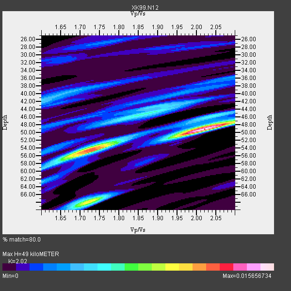
| Thickness Estimate: | 49 km |
| Thickness StdDev: | 4.8 km |
| Vp/Vs Estimate: | 2.02 |
| Vp/Vs StdDev: | 0.15 |
| Vs Estimate: | 3.049 km/s |
| Poisson's Ratio: | 0.34 |
| Peak Value: | 0.02 |
| Assumed Vp: | 6.159 km/s |
| Ps Weight: | 0.33333334 |
| PpPs Weight: | 0.33333334 |
| PsPs Weight: | 0.33333328 |
| Residual Complexity: | 0.730 |
| Nearby stations H: | +- |
| (2.0 deg) Vp/Vs: | +- |
3 with match > 90% ( 42.857143 %) and 7 with match > 80% ( 100.0 %) out of 7.
Download stack as xyz text file.
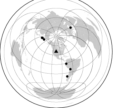
Azimuth Distribution of Events:
Prior Results for this Station
| Study | Thickness | Vp/Vs | Vp | Vs | Poissons Ratio | Extra |
| EARS | 49 km | 2.02 | 6.159 km/s | 3.049 km/s | 0.34 | |
| Crust2.0 | 46 km | 1.76 | 6.159 km/s | 3.507 km/s | 0.26 | P1,orogen/46km, Urals, Tethian Orogen, 2 km seds. |
| Global Maxima | 49 km | 2.02 | 6.159 km/s | 3.049 km/s | 0.34 | amp=0.015656734 |
| Local Maxima 1 | 55 km | 1.72 | 6.159 km/s | 3.581 km/s | 0.24 | amp=0.010005227 |
| Local Maxima 2 | 68 km | 1.73 | 6.159 km/s | 3.57 km/s | 0.25 | amp=0.009729109 |
| Local Maxima 3 | 45 km | 1.88 | 6.159 km/s | 3.272 km/s | 0.30 | amp=0.0051318607 |
| Local Maxima 4 | 42 km | 1.60 | 6.159 km/s | 3.843 km/s | 0.18 | amp=0.0047929673 |
| Predicted Arrivals for vertical incidence (zero ray parameter) | |
| Ps | 8.12 SECOND |
| PpPs | 24.03 SECOND |
| PsPs/PpSs | 32.14 SECOND |
Events Processed for this Station
Download zip of receiver functions as SAC
Plot maxima for each earthquake.
Events Used in the Stack
(7 events)| Radial Match | Distance | Baz | FERegion | Time | Lat/Lon | Depth | Magnitude |
| 97.01245 | 89.6 deg | 31.134 deg | Turkey | 1999/08/17 00:01:39 GMT | (40.7, 29.9) | 17 km | 6.3 MB, 7.8 MS, 7.7 ME, 7.6 MW |
| 93.634865 | 72.1 deg | 140.876 deg | Southern Bolivia | 1999/09/15 03:01:24 GMT | (-20.9, -67.3) | 218 km | 6.0 MB, 6.4 MW, 6.4 MW |
| 90.39279 | 50.2 deg | 139.851 deg | Ecuador | 1999/08/28 12:40:06 GMT | (-1.3, -77.5) | 196 km | 5.9 MB, 6.3 MW, 6.2 MW |
| 86.90408 | 62.1 deg | 314.864 deg | Near East Coast Of Kamchatka | 1999/09/18 21:28:33 GMT | (51.2, 157.6) | 60 km | 5.9 MB, 5.6 MS, 6.2 MW, 6.0 MW |
| 83.46166 | 63.5 deg | 314.154 deg | Kuril Islands | 1999/08/06 00:32:41 GMT | (49.9, 156.3) | 58 km | 5.5 MB, 5.5 MS, 5.9 MW, 5.8 MW |
| 81.819916 | 54.8 deg | 314.856 deg | Komandorskiye Ostrova Region | 1999/09/28 05:00:42 GMT | (54.6, 168.3) | 33 km | 5.4 MB, 6.1 MS, 6.1 MW, 6.1 MW |
| 81.03539 | 86.6 deg | 155.773 deg | Off Coast Of Southern Chile | 1999/08/22 09:35:39 GMT | (-40.5, -74.8) | 33 km | 6.2 MB, 5.8 MS, 6.4 MW, 6.2 MW |
Losers
(0 events)| Radial Match | Distance | Baz | FERegion | Time | Lat/Lon | Depth | Magnitude | Reason |
