
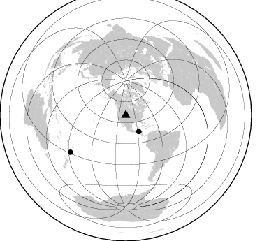
Station XK N14 - North 14
Network: XK99 - CDROM (Colorado)
Nearby stations (2 deg radius)

| Station | Name | (Lat, Lon) | Start / End | Elevation |
| N14 | North 14 | (41.08, -107.18) | 1999-06-09 / 2000-12-31 | 2.2 km |
| Crust2 Type: | P1,orogen/46km, Urals, Tethian Orogen, 2 km seds. |
| Thickness Estimate: | 47 km |
| Thickness StdDev: | 6.8 km |
| Vp/Vs Estimate: | 1.60 |
| Vp/Vs StdDev: | 0.13 |
| Vs Estimate: | 3.849 km/s |
| Poisson's Ratio: | 0.18 |
| Peak Value: | 0.08 |
| Assumed Vp: | 6.159 km/s |
| Ps Weight: | 0.33333334 |
| PpPs Weight: | 0.33333334 |
| PsPs Weight: | 0.33333328 |
| Residual Complexity: | 0.898 |
| Nearby stations H: | 46 km +- 0.7 km |
| (2.0 deg) Vp/Vs: | 1.64 +- 0.06 |
0 with match > 90% ( 0.0 %) and 2 with match > 80% ( 100.0 %) out of 2.
Download stack as xyz text file.
Azimuth Distribution of Events:
Prior Results for this Station
| Study | Thickness | Vp/Vs | Vp | Vs | Poissons Ratio | Extra |
| EARS | 47 km | 1.60 | 6.159 km/s | 3.849 km/s | 0.18 | |
| Crust2.0 | 46 km | 1.76 | 6.159 km/s | 3.507 km/s | 0.26 | P1,orogen/46km, Urals, Tethian Orogen, 2 km seds. |
| Global Maxima | 47 km | 1.60 | 6.159 km/s | 3.849 km/s | 0.18 | amp=0.07540049 |
| Local Maxima 1 | 38 km | 2.10 | 6.159 km/s | 2.936 km/s | 0.35 | amp=0.07119579 |
| Local Maxima 2 | 56 km | 1.76 | 6.159 km/s | 3.499 km/s | 0.26 | amp=0.06543608 |
| Local Maxima 3 | 50 km | 1.60 | 6.159 km/s | 3.849 km/s | 0.18 | amp=0.055953916 |
| Local Maxima 4 | 38 km | 1.75 | 6.159 km/s | 3.529 km/s | 0.26 | amp=0.052185852 |
| Predicted Arrivals for vertical incidence (zero ray parameter) | |
| Ps | 4.60 SECOND |
| PpPs | 19.95 SECOND |
| PsPs/PpSs | 24.55 SECOND |
Events Processed for this Station
Download zip of receiver functions as SAC
Plot maxima for each earthquake.
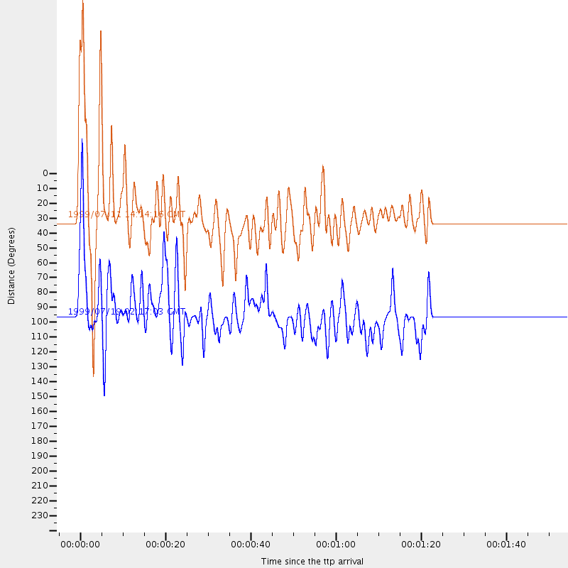
Events Used in the Stack
(2 events)| Radial Match | Distance | Baz | FERegion | Time | Lat/Lon | Depth | Magnitude |
| 87.671425 | 30.0 deg | 141.58 deg | Honduras | 1999/07/11 14:14:16 GMT | (15.8, -88.3) | 10 km | 6.0 MB, 6.6 MS, 6.7 MW, 6.3 ME |
| 83.00585 | 95.1 deg | 236.269 deg | Kermadec Islands Region | 1999/07/19 02:17:03 GMT | (-28.6, -177.6) | 39 km | 6.3 MB, 6.2 MS, 6.4 MW, 6.3 ME |
Losers
(0 events)| Radial Match | Distance | Baz | FERegion | Time | Lat/Lon | Depth | Magnitude | Reason |
