
Station XK N20 - North 20
Network: XK99 - CDROM (Colorado)
Nearby stations (2 deg radius)
| Station | Name | (Lat, Lon) | Start / End | Elevation |
| N20 | North 20 | (40.57, -106.88) | 1999-06-11 / 2000-12-31 | 2173 m |
| Crust2 Type: | P1,orogen/46km, Urals, Tethian Orogen, 2 km seds. |
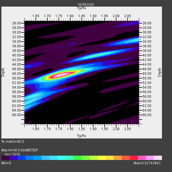
| Thickness Estimate: | 48 km |
| Thickness StdDev: | 4.6 km |
| Vp/Vs Estimate: | 1.76 |
| Vp/Vs StdDev: | 0.07 |
| Vs Estimate: | 3.504 km/s |
| Poisson's Ratio: | 0.26 |
| Peak Value: | 0.03 |
| Assumed Vp: | 6.159 km/s |
| Ps Weight: | 0.33333334 |
| PpPs Weight: | 0.33333334 |
| PsPs Weight: | 0.33333328 |
| Residual Complexity: | 0.412 |
| Nearby stations H: | +- |
| (2.0 deg) Vp/Vs: | +- |
5 with match > 90% ( 50.0 %) and 10 with match > 80% ( 100.0 %) out of 10.
Download stack as xyz text file.
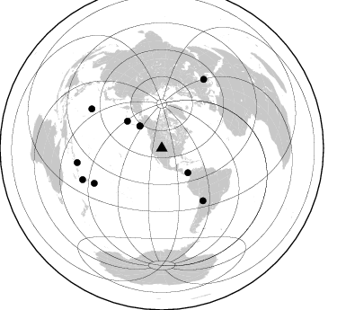
Azimuth Distribution of Events:
Prior Results for this Station
| Study | Thickness | Vp/Vs | Vp | Vs | Poissons Ratio | Extra |
| EARS | 48 km | 1.76 | 6.159 km/s | 3.504 km/s | 0.26 | |
| Crust2.0 | 46 km | 1.76 | 6.159 km/s | 3.507 km/s | 0.26 | P1,orogen/46km, Urals, Tethian Orogen, 2 km seds. |
| Global Maxima | 48 km | 1.76 | 6.159 km/s | 3.504 km/s | 0.26 | amp=0.02743843 |
| Local Maxima 1 | 48 km | 1.75 | 6.159 km/s | 3.524 km/s | 0.26 | amp=0.009390797 |
| Local Maxima 2 | 33 km | 2.10 | 6.159 km/s | 2.936 km/s | 0.35 | amp=0.008597712 |
| Local Maxima 3 | 62 km | 1.61 | 6.159 km/s | 3.831 km/s | 0.18 | amp=0.007171185 |
| Local Maxima 4 | 40 km | 1.94 | 6.159 km/s | 3.179 km/s | 0.32 | amp=0.0055233953 |
| Predicted Arrivals for vertical incidence (zero ray parameter) | |
| Ps | 5.97 SECOND |
| PpPs | 21.72 SECOND |
| PsPs/PpSs | 27.68 SECOND |
Events Processed for this Station
Download zip of receiver functions as SAC
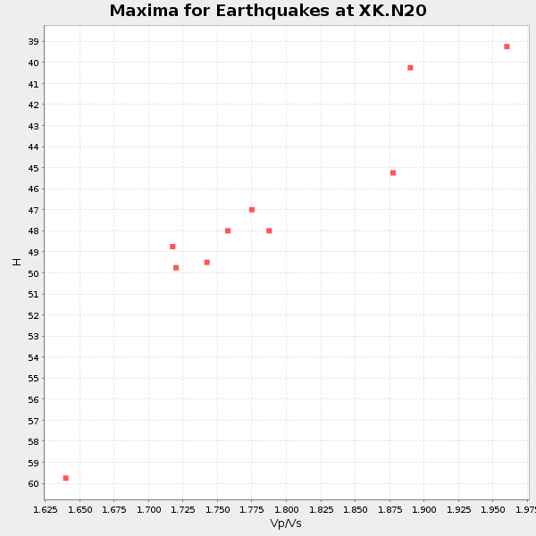
Plot maxima for each earthquake.
Events Used in the Stack
(10 events)| Radial Match | Distance | Baz | FERegion | Time | Lat/Lon | Depth | Magnitude |
| 97.80737 | 89.4 deg | 299.146 deg | Volcano Islands, Japan Region | 2000/03/28 11:00:22 GMT | (22.3, 143.7) | 126 km | 6.8 MB, 7.6 MS, 7.6 MW, 7.6 MW |
| 97.12313 | 74.0 deg | 141.761 deg | Jujuy Province, Argentina | 2000/05/12 18:43:18 GMT | (-23.5, -66.5) | 225 km | 6.2 MB, 7.2 MW, 7.1 MW |
| 95.21593 | 34.6 deg | 315.329 deg | Kodiak Island Region, Alaska | 1999/12/06 23:12:33 GMT | (57.4, -154.5) | 66 km | 6.8 MB, 7.0 MW, 7.0 ML |
| 92.187096 | 90.0 deg | 31.375 deg | Turkey | 1999/08/17 00:01:39 GMT | (40.7, 29.9) | 17 km | 6.3 MB, 7.8 MS, 7.7 ME, 7.6 MW |
| 91.67497 | 84.7 deg | 242.546 deg | Tonga Islands | 2000/01/08 16:47:20 GMT | (-16.9, -174.2) | 183 km | 6.5 MB, 6.6 MS, 7.2 MW, 7.0 ME |
| 86.77569 | 48.8 deg | 308.025 deg | Andreanof Islands, Aleutian Is. | 2000/04/21 04:35:17 GMT | (51.4, -178.1) | 33 km | 6.0 MB, 5.7 MS, 6.2 ML, 6.0 MW |
| 85.48756 | 34.7 deg | 315.237 deg | Kodiak Island Region, Alaska | 1999/12/07 00:19:49 GMT | (57.4, -154.5) | 41 km | 6.5 MB, 6.1 MS, 6.4 MW, 6.3 ML |
| 84.508965 | 94.7 deg | 248.421 deg | Vanuatu Islands Region | 2000/02/25 01:43:58 GMT | (-19.5, 173.8) | 33 km | 6.1 MB, 7.1 MS, 7.1 MW, 7.0 MW |
| 82.02613 | 39.9 deg | 133.129 deg | Panama | 2000/02/26 18:24:39 GMT | (9.4, -78.5) | 65 km | 5.8 MB, 5.4 MS, 6.2 MW, 6.1 MW |
| 81.88722 | 95.3 deg | 260.322 deg | Santa Cruz Islands | 1999/12/29 13:29:19 GMT | (-10.9, 165.4) | 33 km | 5.6 MB, 6.8 MS, 6.8 MW, 6.3 MW |
Losers
(0 events)| Radial Match | Distance | Baz | FERegion | Time | Lat/Lon | Depth | Magnitude | Reason |
