
Station XK N26 - North 26
Network: XK99 - CDROM (Colorado)
Nearby stations (2 deg radius)
| Station | Name | (Lat, Lon) | Start / End | Elevation |
| N26 | North 26 | (40.05, -106.66) | 1999-06-18 / 2000-12-31 | 2642 m |
| Crust2 Type: | P1,orogen/46km, Urals, Tethian Orogen, 2 km seds. |
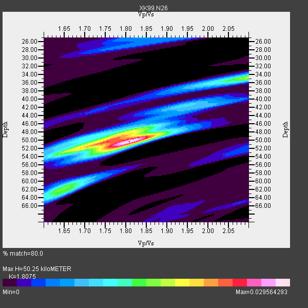
| Thickness Estimate: | 50 km |
| Thickness StdDev: | 5.0 km |
| Vp/Vs Estimate: | 1.81 |
| Vp/Vs StdDev: | 0.09 |
| Vs Estimate: | 3.407 km/s |
| Poisson's Ratio: | 0.28 |
| Peak Value: | 0.03 |
| Assumed Vp: | 6.159 km/s |
| Ps Weight: | 0.33333334 |
| PpPs Weight: | 0.33333334 |
| PsPs Weight: | 0.33333328 |
| Residual Complexity: | 0.629 |
| Nearby stations H: | +- |
| (2.0 deg) Vp/Vs: | +- |
3 with match > 90% ( 33.333332 %) and 9 with match > 80% ( 100.0 %) out of 9.
Download stack as xyz text file.
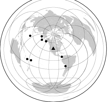
Azimuth Distribution of Events:
Prior Results for this Station
| Study | Thickness | Vp/Vs | Vp | Vs | Poissons Ratio | Extra |
| EARS | 50 km | 1.81 | 6.159 km/s | 3.407 km/s | 0.28 | |
| Crust2.0 | 46 km | 1.76 | 6.159 km/s | 3.507 km/s | 0.26 | P1,orogen/46km, Urals, Tethian Orogen, 2 km seds. |
| Global Maxima | 50 km | 1.81 | 6.159 km/s | 3.407 km/s | 0.28 | amp=0.029564293 |
| Local Maxima 1 | 50 km | 1.75 | 6.159 km/s | 3.509 km/s | 0.26 | amp=0.019086014 |
| Local Maxima 2 | 34 km | 2.10 | 6.159 km/s | 2.936 km/s | 0.35 | amp=0.015719874 |
| Local Maxima 3 | 62 km | 1.63 | 6.159 km/s | 3.773 km/s | 0.20 | amp=0.011046873 |
| Local Maxima 4 | 50 km | 1.69 | 6.159 km/s | 3.65 km/s | 0.23 | amp=0.009740087 |
| Predicted Arrivals for vertical incidence (zero ray parameter) | |
| Ps | 6.59 SECOND |
| PpPs | 22.91 SECOND |
| PsPs/PpSs | 29.50 SECOND |
Events Processed for this Station
Download zip of receiver functions as SAC
Plot maxima for each earthquake.
Events Used in the Stack
(9 events)| Radial Match | Distance | Baz | FERegion | Time | Lat/Lon | Depth | Magnitude |
| 97.162254 | 89.8 deg | 299.292 deg | Volcano Islands, Japan Region | 2000/03/28 11:00:22 GMT | (22.3, 143.7) | 126 km | 6.8 MB, 7.6 MS, 7.6 MW, 7.6 MW |
| 95.20363 | 84.6 deg | 242.74 deg | Tonga Islands | 2000/01/08 16:47:20 GMT | (-16.9, -174.2) | 183 km | 6.5 MB, 6.6 MS, 7.2 MW, 7.0 ME |
| 90.87194 | 57.3 deg | 317.0 deg | Komandorskiye Ostrova Region | 1999/11/26 00:29:00 GMT | (55.1, 165.4) | 33 km | 5.6 MB, 5.8 MS |
| 89.392365 | 35.1 deg | 315.815 deg | Kodiak Island Region, Alaska | 1999/12/06 23:12:33 GMT | (57.4, -154.5) | 66 km | 6.8 MB, 7.0 MW, 7.0 ML |
| 86.42333 | 94.7 deg | 248.52 deg | Vanuatu Islands Region | 2000/02/25 01:43:58 GMT | (-19.5, 173.8) | 33 km | 6.1 MB, 7.1 MS, 7.1 MW, 7.0 MW |
| 86.05346 | 49.3 deg | 308.428 deg | Andreanof Islands, Aleutian Is. | 2000/04/21 04:35:17 GMT | (51.4, -178.1) | 33 km | 6.0 MB, 5.7 MS, 6.2 ML, 6.0 MW |
| 83.690094 | 35.1 deg | 315.724 deg | Kodiak Island Region, Alaska | 1999/12/07 00:19:49 GMT | (57.4, -154.5) | 41 km | 6.5 MB, 6.1 MS, 6.4 MW, 6.3 ML |
| 80.53751 | 39.5 deg | 132.958 deg | Panama | 2000/02/26 18:24:39 GMT | (9.4, -78.5) | 65 km | 5.8 MB, 5.4 MS, 6.2 MW, 6.1 MW |
| 80.40945 | 71.5 deg | 144.716 deg | Near Coast Of Northern Chile | 2000/01/08 11:59:21 GMT | (-23.2, -70.1) | 36 km | 5.8 MB, 5.9 MS, 6.4 MW, 6.1 ME |
Losers
(0 events)| Radial Match | Distance | Baz | FERegion | Time | Lat/Lon | Depth | Magnitude | Reason |
