
Station XK S06 - South 06
Network: XK99 - CDROM (Colorado)
Nearby stations (2 deg radius)
| Station | Name | (Lat, Lon) | Start / End | Elevation |
| S06 | South 06 | (36.81, -105.30) | 1999-04-22 / 2000-12-31 | 2.8 km |
| Crust2 Type: | PC,orogen/45km, Orogen, 1 km seds. |
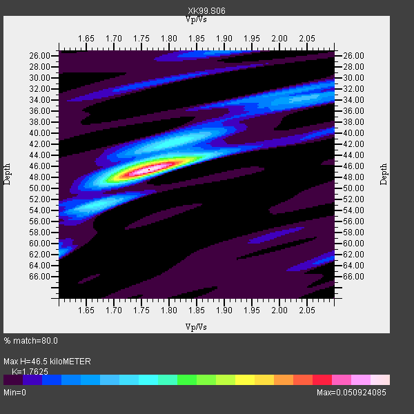
| Thickness Estimate: | 46 km |
| Thickness StdDev: | 0.7 km |
| Vp/Vs Estimate: | 1.76 |
| Vp/Vs StdDev: | 0.02 |
| Vs Estimate: | 3.583 km/s |
| Poisson's Ratio: | 0.26 |
| Peak Value: | 0.05 |
| Assumed Vp: | 6.316 km/s |
| Ps Weight: | 0.33333334 |
| PpPs Weight: | 0.33333334 |
| PsPs Weight: | 0.33333328 |
| Residual Complexity: | 0.418 |
| Nearby stations H: | +- |
| (2.0 deg) Vp/Vs: | +- |
4 with match > 90% ( 40.0 %) and 10 with match > 80% ( 100.0 %) out of 10.
Download stack as xyz text file.
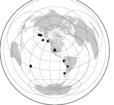
Azimuth Distribution of Events:
Prior Results for this Station
| Study | Thickness | Vp/Vs | Vp | Vs | Poissons Ratio | Extra |
| EARS | 46 km | 1.76 | 6.316 km/s | 3.583 km/s | 0.26 | |
| Crust2.0 | 45 km | 1.76 | 6.316 km/s | 3.587 km/s | 0.26 | PC,orogen/45km, Orogen, 1 km seds. |
| Global Maxima | 46 km | 1.76 | 6.316 km/s | 3.583 km/s | 0.26 | amp=0.050924085 |
| Local Maxima 1 | 45 km | 1.78 | 6.316 km/s | 3.543 km/s | 0.27 | amp=0.016189773 |
| Local Maxima 2 | 62 km | 1.60 | 6.316 km/s | 3.947 km/s | 0.18 | amp=0.012406964 |
| Local Maxima 3 | 42 km | 1.77 | 6.316 km/s | 3.573 km/s | 0.26 | amp=0.011631938 |
| Local Maxima 4 | 34 km | 2.04 | 6.316 km/s | 3.103 km/s | 0.34 | amp=0.010979601 |
| Predicted Arrivals for vertical incidence (zero ray parameter) | |
| Ps | 5.61 SECOND |
| PpPs | 20.34 SECOND |
| PsPs/PpSs | 25.95 SECOND |
Events Processed for this Station
Download zip of receiver functions as SAC
Plot maxima for each earthquake.
Events Used in the Stack
(10 events)| Radial Match | Distance | Baz | FERegion | Time | Lat/Lon | Depth | Magnitude |
| 93.670364 | 67.7 deg | 141.514 deg | Southern Bolivia | 1999/09/15 03:01:24 GMT | (-20.9, -67.3) | 218 km | 6.0 MB, 6.4 MW, 6.4 MW |
| 92.1407 | 81.9 deg | 156.957 deg | Off Coast Of Southern Chile | 1999/08/22 09:35:39 GMT | (-40.5, -74.8) | 33 km | 6.2 MB, 5.8 MS, 6.4 MW, 6.2 MW |
| 92.07775 | 94.0 deg | 237.093 deg | Kermadec Islands Region | 1999/07/19 02:17:03 GMT | (-28.6, -177.6) | 39 km | 6.3 MB, 6.2 MS, 6.4 MW, 6.3 ME |
| 91.97963 | 45.8 deg | 139.529 deg | Ecuador | 1999/08/28 12:40:06 GMT | (-1.3, -77.5) | 196 km | 5.9 MB, 6.3 MW, 6.2 MW |
| 86.511734 | 68.5 deg | 315.916 deg | Kuril Islands | 1999/07/07 18:52:57 GMT | (49.2, 155.6) | 33 km | 6.0 MB, 5.6 MS, 6.1 MW, 5.8 ME |
| 86.17005 | 66.4 deg | 317.051 deg | Near East Coast Of Kamchatka | 1999/09/18 21:28:33 GMT | (51.2, 157.6) | 60 km | 5.9 MB, 5.6 MS, 6.2 MW, 6.0 MW |
| 84.4986 | 37.2 deg | 322.161 deg | Kenai Peninsula, Alaska | 1999/05/05 10:30:03 GMT | (59.3, -151.5) | 71 km | 5.4 MB, 5.8 MW, 5.8 MW |
| 83.52922 | 51.0 deg | 310.537 deg | Andreanof Islands, Aleutian Is. | 1999/08/01 12:47:50 GMT | (51.5, -176.3) | 33 km | 5.5 MB, 5.5 MS, 5.8 MW, 5.8 MW |
| 82.36944 | 72.8 deg | 314.122 deg | Kuril Islands | 1999/05/08 19:44:35 GMT | (45.4, 151.6) | 63 km | 6.2 MB, 5.3 MS, 5.9 MW, 5.9 MW |
| 82.28219 | 95.3 deg | 235.884 deg | Kermadec Islands, New Zealand | 1999/08/01 08:39:04 GMT | (-30.4, -177.8) | 10 km | 5.7 MB, 6.4 MS, 6.6 MW, 6.0 ME |
Losers
(0 events)| Radial Match | Distance | Baz | FERegion | Time | Lat/Lon | Depth | Magnitude | Reason |
