
Station XK S08 - South 08
Network: XK99 - CDROM (Colorado)
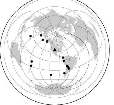
Nearby stations (2 deg radius)
| Station | Name | (Lat, Lon) | Start / End | Elevation |
| S08 | South 08 | (36.61, -105.32) | 1999-04-21 / 2000-12-31 | 2656 m |
| Crust2 Type: | PC,orogen/45km, Orogen, 1 km seds. |
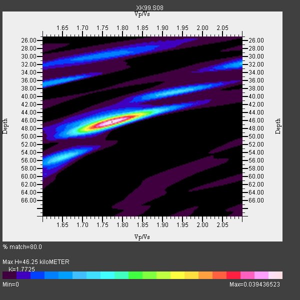
| Thickness Estimate: | 46 km |
| Thickness StdDev: | 2.1 km |
| Vp/Vs Estimate: | 1.77 |
| Vp/Vs StdDev: | 0.02 |
| Vs Estimate: | 3.563 km/s |
| Poisson's Ratio: | 0.27 |
| Peak Value: | 0.04 |
| Assumed Vp: | 6.316 km/s |
| Ps Weight: | 0.33333334 |
| PpPs Weight: | 0.33333334 |
| PsPs Weight: | 0.33333328 |
| Residual Complexity: | 0.358 |
| Nearby stations H: | +- |
| (2.0 deg) Vp/Vs: | +- |
8 with match > 90% ( 53.333332 %) and 15 with match > 80% ( 100.0 %) out of 15.
Download stack as xyz text file.
Azimuth Distribution of Events:
Prior Results for this Station
| Study | Thickness | Vp/Vs | Vp | Vs | Poissons Ratio | Extra |
| EARS | 46 km | 1.77 | 6.316 km/s | 3.563 km/s | 0.27 | |
| Crust2.0 | 45 km | 1.76 | 6.316 km/s | 3.587 km/s | 0.26 | PC,orogen/45km, Orogen, 1 km seds. |
| Global Maxima | 46 km | 1.77 | 6.316 km/s | 3.563 km/s | 0.27 | amp=0.039436523 |
| Local Maxima 1 | 44 km | 1.81 | 6.316 km/s | 3.484 km/s | 0.28 | amp=0.011780129 |
| Local Maxima 2 | 48 km | 1.73 | 6.316 km/s | 3.645 km/s | 0.25 | amp=0.009768674 |
| Local Maxima 3 | 36 km | 1.62 | 6.316 km/s | 3.886 km/s | 0.20 | amp=0.009723279 |
| Local Maxima 4 | 32 km | 2.10 | 6.316 km/s | 3.011 km/s | 0.35 | amp=0.008716624 |
| Predicted Arrivals for vertical incidence (zero ray parameter) | |
| Ps | 5.66 SECOND |
| PpPs | 20.30 SECOND |
| PsPs/PpSs | 25.96 SECOND |
Events Processed for this Station
Download zip of receiver functions as SAC
Plot maxima for each earthquake.
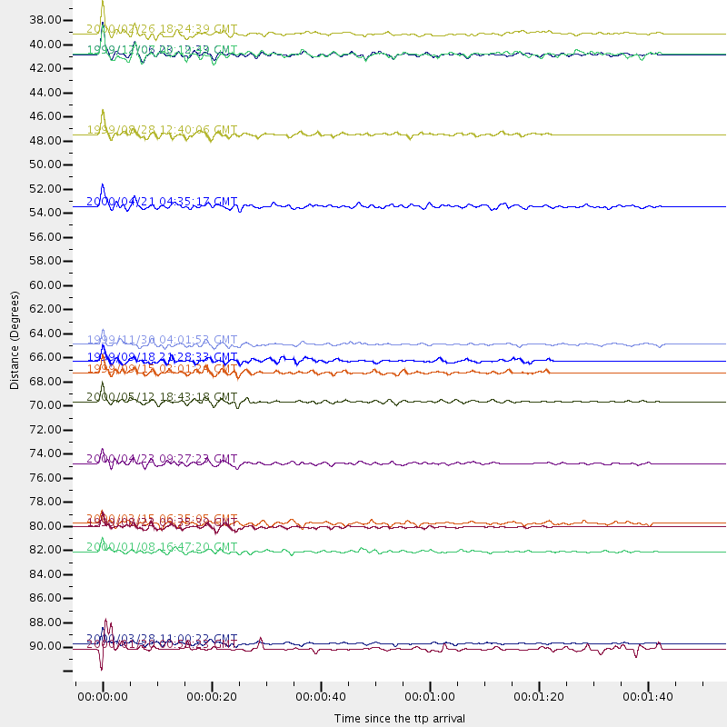
Events Used in the Stack
(15 events)| Radial Match | Distance | Baz | FERegion | Time | Lat/Lon | Depth | Magnitude |
| 98.26503 | 92.4 deg | 300.069 deg | Volcano Islands, Japan Region | 2000/03/28 11:00:22 GMT | (22.3, 143.7) | 126 km | 6.8 MB, 7.6 MS, 7.6 MW, 7.6 MW |
| 97.71971 | 70.2 deg | 142.255 deg | Jujuy Province, Argentina | 2000/05/12 18:43:18 GMT | (-23.5, -66.5) | 225 km | 6.2 MB, 7.2 MW, 7.1 MW |
| 95.94186 | 75.9 deg | 142.24 deg | Santiago Del Estero Prov., Arg. | 2000/04/23 09:27:23 GMT | (-28.3, -63.0) | 608 km | 6.6 MB, 7.0 MW, 7.0 MW |
| 95.63741 | 84.0 deg | 243.92 deg | Tonga Islands | 2000/01/08 16:47:20 GMT | (-16.9, -174.2) | 183 km | 6.5 MB, 6.6 MS, 7.2 MW, 7.0 ME |
| 95.14535 | 38.4 deg | 318.725 deg | Kodiak Island Region, Alaska | 1999/12/06 23:12:33 GMT | (57.4, -154.5) | 66 km | 6.8 MB, 7.0 MW, 7.0 ML |
| 94.657906 | 81.7 deg | 156.932 deg | Off Coast Of Southern Chile | 1999/08/22 09:35:39 GMT | (-40.5, -74.8) | 33 km | 6.2 MB, 5.8 MS, 6.4 MW, 6.2 MW |
| 94.25207 | 45.7 deg | 139.385 deg | Ecuador | 1999/08/28 12:40:06 GMT | (-1.3, -77.5) | 196 km | 5.9 MB, 6.3 MW, 6.2 MW |
| 90.275406 | 36.4 deg | 131.424 deg | Panama | 2000/02/26 18:24:39 GMT | (9.4, -78.5) | 65 km | 5.8 MB, 5.4 MS, 6.2 MW, 6.1 MW |
| 87.85269 | 67.6 deg | 141.448 deg | Southern Bolivia | 1999/09/15 03:01:24 GMT | (-20.9, -67.3) | 218 km | 6.0 MB, 6.4 MW, 6.4 MW |
| 87.40821 | 52.3 deg | 310.863 deg | Andreanof Islands, Aleutian Is. | 2000/04/21 04:35:17 GMT | (51.4, -178.1) | 33 km | 6.0 MB, 5.7 MS, 6.2 ML, 6.0 MW |
| 85.43987 | 64.9 deg | 141.929 deg | Northern Chile | 1999/11/30 04:01:53 GMT | (-18.9, -69.2) | 128 km | 6.2 MB, 6.6 MW, 6.5 MW |
| 85.215004 | 38.4 deg | 318.64 deg | Kodiak Island Region, Alaska | 1999/12/07 00:19:49 GMT | (57.4, -154.5) | 41 km | 6.5 MB, 6.1 MS, 6.4 MW, 6.3 ML |
| 85.115204 | 81.4 deg | 188.751 deg | South Pacific Ocean | 2000/03/15 06:35:05 GMT | (-44.4, -117.4) | 10 km | 5.9 MB, 5.5 MS, 5.9 MW |
| 83.72853 | 66.5 deg | 317.101 deg | Near East Coast Of Kamchatka | 1999/09/18 21:28:33 GMT | (51.2, 157.6) | 60 km | 5.9 MB, 5.6 MS, 6.2 MW, 6.0 MW |
| 81.39723 | 92.9 deg | 236.784 deg | Kermadec Islands Region | 2000/01/20 00:59:23 GMT | (-28.2, -176.6) | 33 km | 5.4 MB, 5.5 MS, 5.7 MW, 5.7 MW |
Losers
(0 events)| Radial Match | Distance | Baz | FERegion | Time | Lat/Lon | Depth | Magnitude | Reason |
