
Station XK S13 - South 13
Network: XK99 - CDROM (Colorado)
Nearby stations (2 deg radius)
| Station | Name | (Lat, Lon) | Start / End | Elevation |
| S13 | South 13 | (36.15, -105.26) | 1999-04-19 / 2000-12-31 | 2369 m |
| Crust2 Type: | PC,orogen/45km, Orogen, 1 km seds. |
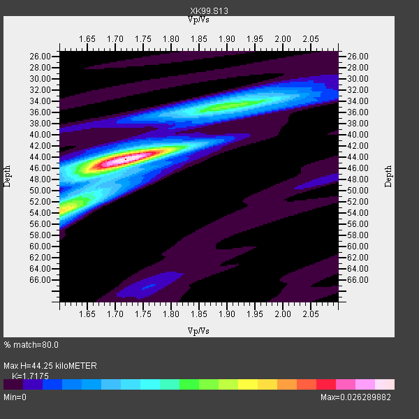
| Thickness Estimate: | 44 km |
| Thickness StdDev: | 3.1 km |
| Vp/Vs Estimate: | 1.72 |
| Vp/Vs StdDev: | 0.04 |
| Vs Estimate: | 3.677 km/s |
| Poisson's Ratio: | 0.24 |
| Peak Value: | 0.03 |
| Assumed Vp: | 6.316 km/s |
| Ps Weight: | 0.33333334 |
| PpPs Weight: | 0.33333334 |
| PsPs Weight: | 0.33333328 |
| Residual Complexity: | 0.544 |
| Nearby stations H: | +- |
| (2.0 deg) Vp/Vs: | +- |
10 with match > 90% ( 41.666668 %) and 24 with match > 80% ( 100.0 %) out of 24.
Download stack as xyz text file.
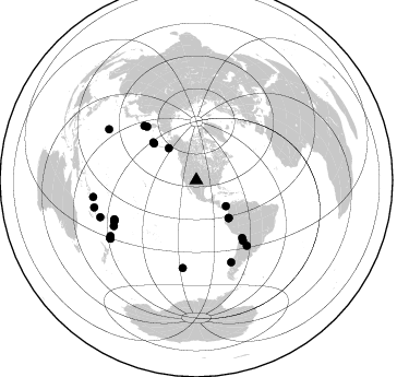
Azimuth Distribution of Events:
Prior Results for this Station
| Study | Thickness | Vp/Vs | Vp | Vs | Poissons Ratio | Extra |
| EARS | 44 km | 1.72 | 6.316 km/s | 3.677 km/s | 0.24 | |
| Crust2.0 | 45 km | 1.76 | 6.316 km/s | 3.587 km/s | 0.26 | PC,orogen/45km, Orogen, 1 km seds. |
| Global Maxima | 44 km | 1.72 | 6.316 km/s | 3.677 km/s | 0.24 | amp=0.026289882 |
| Local Maxima 1 | 35 km | 1.90 | 6.316 km/s | 3.32 km/s | 0.31 | amp=0.012941866 |
| Local Maxima 2 | 53 km | 1.61 | 6.316 km/s | 3.929 km/s | 0.18 | amp=0.011540507 |
| Local Maxima 3 | 44 km | 1.69 | 6.316 km/s | 3.737 km/s | 0.23 | amp=0.006423211 |
| Local Maxima 4 | 55 km | 1.60 | 6.316 km/s | 3.947 km/s | 0.18 | amp=0.0052980054 |
| Predicted Arrivals for vertical incidence (zero ray parameter) | |
| Ps | 5.03 SECOND |
| PpPs | 19.04 SECOND |
| PsPs/PpSs | 24.07 SECOND |
Events Processed for this Station
Download zip of receiver functions as SAC
Plot maxima for each earthquake.
Events Used in the Stack
(24 events)| Radial Match | Distance | Baz | FERegion | Time | Lat/Lon | Depth | Magnitude |
| 98.392685 | 92.7 deg | 300.09 deg | Volcano Islands, Japan Region | 2000/03/28 11:00:22 GMT | (22.3, 143.7) | 126 km | 6.8 MB, 7.6 MS, 7.6 MW, 7.6 MW |
| 96.29094 | 38.7 deg | 319.096 deg | Kodiak Island Region, Alaska | 1999/12/06 23:12:33 GMT | (57.4, -154.5) | 66 km | 6.8 MB, 7.0 MW, 7.0 ML |
| 96.034164 | 69.8 deg | 142.203 deg | Jujuy Province, Argentina | 2000/05/12 18:43:18 GMT | (-23.5, -66.5) | 225 km | 6.2 MB, 7.2 MW, 7.1 MW |
| 95.19908 | 93.7 deg | 237.08 deg | Kermadec Islands Region | 1999/07/19 02:17:03 GMT | (-28.6, -177.6) | 39 km | 6.3 MB, 6.2 MS, 6.4 MW, 6.3 ME |
| 94.98188 | 83.8 deg | 244.004 deg | Tonga Islands | 2000/01/08 16:47:20 GMT | (-16.9, -174.2) | 183 km | 6.5 MB, 6.6 MS, 7.2 MW, 7.0 ME |
| 94.337074 | 45.3 deg | 139.164 deg | Ecuador | 1999/08/28 12:40:06 GMT | (-1.3, -77.5) | 196 km | 5.9 MB, 6.3 MW, 6.2 MW |
| 93.18666 | 75.5 deg | 142.215 deg | Santiago Del Estero Prov., Arg. | 2000/04/23 09:27:23 GMT | (-28.3, -63.0) | 608 km | 6.6 MB, 7.0 MW, 7.0 MW |
| 92.89921 | 94.3 deg | 249.064 deg | Vanuatu Islands Region | 2000/02/25 01:43:58 GMT | (-19.5, 173.8) | 33 km | 6.1 MB, 7.1 MS, 7.1 MW, 7.0 MW |
| 92.80089 | 81.3 deg | 156.949 deg | Off Coast Of Southern Chile | 1999/08/22 09:35:39 GMT | (-40.5, -74.8) | 33 km | 6.2 MB, 5.8 MS, 6.4 MW, 6.2 MW |
| 90.128555 | 94.9 deg | 235.86 deg | Kermadec Islands, New Zealand | 1999/08/01 08:39:04 GMT | (-30.4, -177.8) | 10 km | 5.7 MB, 6.4 MS, 6.6 MW, 6.0 ME |
| 88.58193 | 95.8 deg | 260.88 deg | Santa Cruz Islands | 1999/12/29 13:29:19 GMT | (-10.9, 165.4) | 33 km | 5.6 MB, 6.8 MS, 6.8 MW, 6.3 MW |
| 88.48537 | 96.7 deg | 255.075 deg | Vanuatu Islands | 1999/08/22 12:40:45 GMT | (-16.1, 168.0) | 33 km | 6.3 MB, 6.2 MS, 6.5 MW, 6.5 MW |
| 88.12177 | 69.0 deg | 316.109 deg | Kuril Islands | 1999/07/07 18:52:57 GMT | (49.2, 155.6) | 33 km | 6.0 MB, 5.6 MS, 6.1 MW, 5.8 ME |
| 87.58754 | 52.6 deg | 311.142 deg | Andreanof Islands, Aleutian Is. | 2000/04/21 04:35:17 GMT | (51.4, -178.1) | 33 km | 6.0 MB, 5.7 MS, 6.2 ML, 6.0 MW |
| 87.39378 | 95.0 deg | 236.023 deg | Kermadec Islands, New Zealand | 1999/07/28 10:08:20 GMT | (-30.3, -178.0) | 25 km | 6.1 MB, 6.0 MS, 6.3 MW, 6.1 ME |
| 86.13351 | 67.2 deg | 141.382 deg | Southern Bolivia | 1999/09/15 03:01:24 GMT | (-20.9, -67.3) | 218 km | 6.0 MB, 6.4 MW, 6.4 MW |
| 85.92752 | 86.3 deg | 241.084 deg | Tonga Islands | 2000/01/02 15:16:32 GMT | (-20.8, -174.2) | 33 km | 5.5 MB, 5.8 MS, 5.8 MW, 5.8 MW |
| 85.726616 | 66.9 deg | 317.258 deg | Near East Coast Of Kamchatka | 1999/09/18 21:28:33 GMT | (51.2, 157.6) | 60 km | 5.9 MB, 5.6 MS, 6.2 MW, 6.0 MW |
| 85.61668 | 51.5 deg | 310.942 deg | Andreanof Islands, Aleutian Is. | 1999/08/01 12:47:50 GMT | (51.5, -176.3) | 33 km | 5.5 MB, 5.5 MS, 5.8 MW, 5.8 MW |
| 85.06942 | 36.0 deg | 131.032 deg | Panama | 2000/02/26 18:24:39 GMT | (9.4, -78.5) | 65 km | 5.8 MB, 5.4 MS, 6.2 MW, 6.1 MW |
| 84.50633 | 80.9 deg | 188.807 deg | South Pacific Ocean | 2000/03/15 06:35:05 GMT | (-44.4, -117.4) | 10 km | 5.9 MB, 5.5 MS, 5.9 MW |
| 84.3359 | 83.9 deg | 243.586 deg | Tonga Islands | 2000/01/26 13:26:50 GMT | (-17.3, -174.0) | 33 km | 5.9 MB, 6.0 MS, 6.4 MW, 6.3 MW |
| 81.36874 | 45.5 deg | 139.708 deg | Ecuador | 1999/04/26 18:17:26 GMT | (-1.6, -77.8) | 173 km | 5.6 MB, 6.0 MW, 6.0 MW |
| 80.96824 | 83.0 deg | 244.609 deg | Tonga Islands | 1999/12/07 21:29:49 GMT | (-15.9, -174.0) | 138 km | 6.2 MB, 6.4 MW, 6.4 MW |
Losers
(0 events)| Radial Match | Distance | Baz | FERegion | Time | Lat/Lon | Depth | Magnitude | Reason |
