
Station XK S14 - South 14
Network: XK99 - CDROM (Colorado)
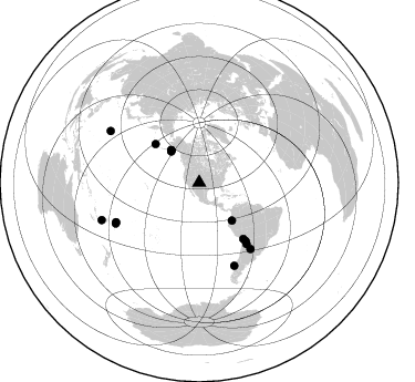
Nearby stations (2 deg radius)
| Station | Name | (Lat, Lon) | Start / End | Elevation |
| S14 | South 14 | (36.07, -105.23) | 1999-04-19 / 2000-12-31 | 2202 m |
| Crust2 Type: | PC,orogen/45km, Orogen, 1 km seds. |
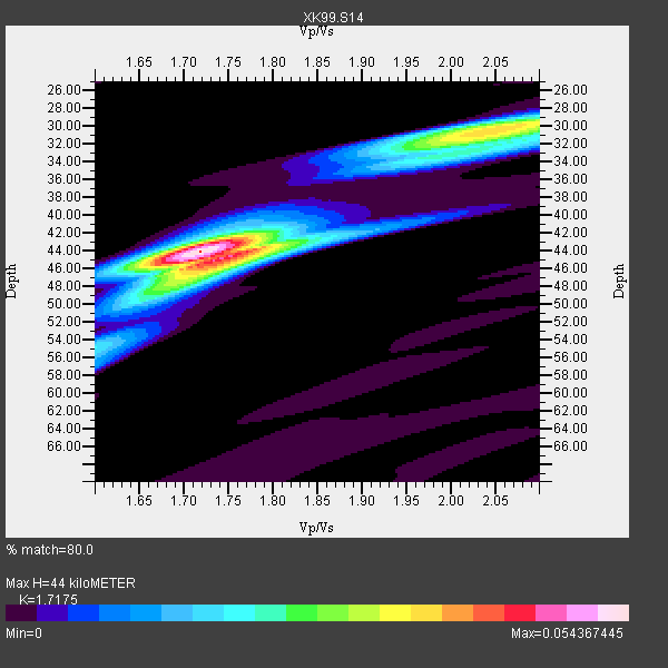
| Thickness Estimate: | 44 km |
| Thickness StdDev: | 1.4 km |
| Vp/Vs Estimate: | 1.72 |
| Vp/Vs StdDev: | 0.03 |
| Vs Estimate: | 3.677 km/s |
| Poisson's Ratio: | 0.24 |
| Peak Value: | 0.05 |
| Assumed Vp: | 6.316 km/s |
| Ps Weight: | 0.33333334 |
| PpPs Weight: | 0.33333334 |
| PsPs Weight: | 0.33333328 |
| Residual Complexity: | 0.639 |
| Nearby stations H: | +- |
| (2.0 deg) Vp/Vs: | +- |
7 with match > 90% ( 50.0 %) and 14 with match > 80% ( 100.0 %) out of 14.
Download stack as xyz text file.
Azimuth Distribution of Events:
Prior Results for this Station
| Study | Thickness | Vp/Vs | Vp | Vs | Poissons Ratio | Extra |
| EARS | 44 km | 1.72 | 6.316 km/s | 3.677 km/s | 0.24 | |
| Crust2.0 | 45 km | 1.76 | 6.316 km/s | 3.587 km/s | 0.26 | PC,orogen/45km, Orogen, 1 km seds. |
| Global Maxima | 44 km | 1.72 | 6.316 km/s | 3.677 km/s | 0.24 | amp=0.054367445 |
| Local Maxima 1 | 30 km | 2.05 | 6.316 km/s | 3.085 km/s | 0.34 | amp=0.03528589 |
| Local Maxima 2 | 45 km | 1.75 | 6.316 km/s | 3.614 km/s | 0.26 | amp=0.032868806 |
| Local Maxima 3 | 32 km | 2.01 | 6.316 km/s | 3.138 km/s | 0.34 | amp=0.017258545 |
| Local Maxima 4 | 48 km | 1.70 | 6.316 km/s | 3.726 km/s | 0.23 | amp=0.014511754 |
| Predicted Arrivals for vertical incidence (zero ray parameter) | |
| Ps | 5.00 SECOND |
| PpPs | 18.93 SECOND |
| PsPs/PpSs | 23.93 SECOND |
Events Processed for this Station
Download zip of receiver functions as SAC
Plot maxima for each earthquake.
Events Used in the Stack
(14 events)| Radial Match | Distance | Baz | FERegion | Time | Lat/Lon | Depth | Magnitude |
| 97.40243 | 92.7 deg | 300.104 deg | Volcano Islands, Japan Region | 2000/03/28 11:00:22 GMT | (22.3, 143.7) | 126 km | 6.8 MB, 7.6 MS, 7.6 MW, 7.6 MW |
| 96.36534 | 69.7 deg | 142.208 deg | Jujuy Province, Argentina | 2000/05/12 18:43:18 GMT | (-23.5, -66.5) | 225 km | 6.2 MB, 7.2 MW, 7.1 MW |
| 95.364746 | 38.8 deg | 319.158 deg | Kodiak Island Region, Alaska | 1999/12/06 23:12:33 GMT | (57.4, -154.5) | 66 km | 6.8 MB, 7.0 MW, 7.0 ML |
| 95.24479 | 83.8 deg | 244.03 deg | Tonga Islands | 2000/01/08 16:47:20 GMT | (-16.9, -174.2) | 183 km | 6.5 MB, 6.6 MS, 7.2 MW, 7.0 ME |
| 91.49315 | 67.1 deg | 141.385 deg | Southern Bolivia | 1999/09/15 03:01:24 GMT | (-20.9, -67.3) | 218 km | 6.0 MB, 6.4 MW, 6.4 MW |
| 91.48972 | 94.3 deg | 249.074 deg | Vanuatu Islands Region | 2000/02/25 01:43:58 GMT | (-19.5, 173.8) | 33 km | 6.1 MB, 7.1 MS, 7.1 MW, 7.0 MW |
| 91.08676 | 81.2 deg | 156.965 deg | Off Coast Of Southern Chile | 1999/08/22 09:35:39 GMT | (-40.5, -74.8) | 33 km | 6.2 MB, 5.8 MS, 6.4 MW, 6.2 MW |
| 89.6972 | 75.4 deg | 142.224 deg | Santiago Del Estero Prov., Arg. | 2000/04/23 09:27:23 GMT | (-28.3, -63.0) | 608 km | 6.6 MB, 7.0 MW, 7.0 MW |
| 89.14872 | 37.8 deg | 317.862 deg | Kodiak Island Region, Alaska | 1999/05/07 14:13:52 GMT | (56.4, -152.9) | 20 km | 5.7 MB, 6.1 MS, 6.4 MW, 5.7 ME |
| 88.24452 | 64.4 deg | 141.852 deg | Northern Chile | 1999/11/30 04:01:53 GMT | (-18.9, -69.2) | 128 km | 6.2 MB, 6.6 MW, 6.5 MW |
| 87.61121 | 45.2 deg | 139.145 deg | Ecuador | 1999/08/28 12:40:06 GMT | (-1.3, -77.5) | 196 km | 5.9 MB, 6.3 MW, 6.2 MW |
| 86.56869 | 38.8 deg | 319.074 deg | Kodiak Island Region, Alaska | 1999/12/07 00:19:49 GMT | (57.4, -154.5) | 41 km | 6.5 MB, 6.1 MS, 6.4 MW, 6.3 ML |
| 84.29201 | 52.7 deg | 311.195 deg | Andreanof Islands, Aleutian Is. | 2000/04/21 04:35:17 GMT | (51.4, -178.1) | 33 km | 6.0 MB, 5.7 MS, 6.2 ML, 6.0 MW |
| 84.02 | 82.9 deg | 244.637 deg | Tonga Islands | 1999/12/07 21:29:49 GMT | (-15.9, -174.0) | 138 km | 6.2 MB, 6.4 MW, 6.4 MW |
Losers
(0 events)| Radial Match | Distance | Baz | FERegion | Time | Lat/Lon | Depth | Magnitude | Reason |
