
Station XK S17 - South 17
Network: XK99 - CDROM (Colorado)
Nearby stations (2 deg radius)
| Station | Name | (Lat, Lon) | Start / End | Elevation |
| S17 | South 17 | (35.79, -105.19) | 1999-12-24 / 2000-12-31 | 2083 m |
| Crust2 Type: | Q2,orogen/39km no ice, Appalachians, North Andes, 0.5 km seds. |
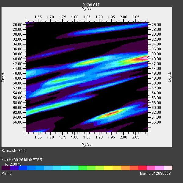
| Thickness Estimate: | 39 km |
| Thickness StdDev: | 9.7 km |
| Vp/Vs Estimate: | 2.10 |
| Vp/Vs StdDev: | 0.15 |
| Vs Estimate: | 3.06 km/s |
| Poisson's Ratio: | 0.35 |
| Peak Value: | 0.01 |
| Assumed Vp: | 6.419 km/s |
| Ps Weight: | 0.33333334 |
| PpPs Weight: | 0.33333334 |
| PsPs Weight: | 0.33333328 |
| Residual Complexity: | 0.802 |
| Nearby stations H: | +- |
| (2.0 deg) Vp/Vs: | +- |
4 with match > 90% ( 57.142857 %) and 7 with match > 80% ( 100.0 %) out of 7.
Download stack as xyz text file.
Azimuth Distribution of Events:

Prior Results for this Station
| Study | Thickness | Vp/Vs | Vp | Vs | Poissons Ratio | Extra |
| EARS | 39 km | 2.10 | 6.419 km/s | 3.06 km/s | 0.35 | |
| Crust2.0 | 39 km | 1.75 | 6.419 km/s | 3.659 km/s | 0.26 | Q2,orogen/39km no ice, Appalachians, North Andes, 0.5 km seds. |
| Global Maxima | 39 km | 2.10 | 6.419 km/s | 3.06 km/s | 0.35 | amp=0.012630558 |
| Local Maxima 1 | 62 km | 1.95 | 6.419 km/s | 3.296 km/s | 0.32 | amp=0.010835904 |
| Local Maxima 2 | 41 km | 1.86 | 6.419 km/s | 3.447 km/s | 0.30 | amp=0.007680223 |
| Local Maxima 3 | 61 km | 1.65 | 6.419 km/s | 3.879 km/s | 0.21 | amp=0.006055279 |
| Local Maxima 4 | 51 km | 1.75 | 6.419 km/s | 3.673 km/s | 0.26 | amp=0.0057249623 |
| Predicted Arrivals for vertical incidence (zero ray parameter) | |
| Ps | 6.71 SECOND |
| PpPs | 18.94 SECOND |
| PsPs/PpSs | 25.65 SECOND |
Events Processed for this Station
Download zip of receiver functions as SAC
Plot maxima for each earthquake.
Events Used in the Stack
(7 events)| Radial Match | Distance | Baz | FERegion | Time | Lat/Lon | Depth | Magnitude |
| 98.37698 | 92.9 deg | 300.119 deg | Volcano Islands, Japan Region | 2000/03/28 11:00:22 GMT | (22.3, 143.7) | 126 km | 6.8 MB, 7.6 MS, 7.6 MW, 7.6 MW |
| 97.47003 | 83.7 deg | 244.085 deg | Tonga Islands | 2000/01/08 16:47:20 GMT | (-16.9, -174.2) | 183 km | 6.5 MB, 6.6 MS, 7.2 MW, 7.0 ME |
| 93.78047 | 69.5 deg | 142.18 deg | Jujuy Province, Argentina | 2000/05/12 18:43:18 GMT | (-23.5, -66.5) | 225 km | 6.2 MB, 7.2 MW, 7.1 MW |
| 91.27425 | 35.8 deg | 130.748 deg | Panama | 2000/02/26 18:24:39 GMT | (9.4, -78.5) | 65 km | 5.8 MB, 5.4 MS, 6.2 MW, 6.1 MW |
| 88.94831 | 83.7 deg | 243.667 deg | Tonga Islands | 2000/01/26 13:26:50 GMT | (-17.3, -174.0) | 33 km | 5.9 MB, 6.0 MS, 6.4 MW, 6.3 MW |
| 86.709366 | 94.2 deg | 249.08 deg | Vanuatu Islands Region | 2000/02/25 01:43:58 GMT | (-19.5, 173.8) | 33 km | 6.1 MB, 7.1 MS, 7.1 MW, 7.0 MW |
| 83.92497 | 95.8 deg | 260.885 deg | Santa Cruz Islands | 1999/12/29 13:29:19 GMT | (-10.9, 165.4) | 33 km | 5.6 MB, 6.8 MS, 6.8 MW, 6.3 MW |
Losers
(0 events)| Radial Match | Distance | Baz | FERegion | Time | Lat/Lon | Depth | Magnitude | Reason |
