
Station XK S18 - South 18
Network: XK99 - CDROM (Colorado)
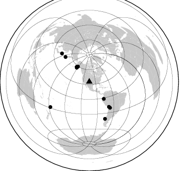
Nearby stations (2 deg radius)
| Station | Name | (Lat, Lon) | Start / End | Elevation |
| S18 | South 18 | (35.70, -105.17) | 1999-04-18 / 2000-12-31 | 2010 m |
| Crust2 Type: | Q2,orogen/39km no ice, Appalachians, North Andes, 0.5 km seds. |
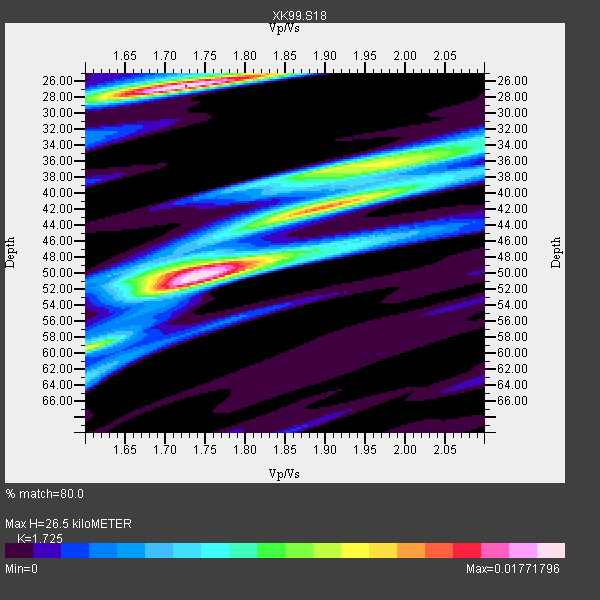
| Thickness Estimate: | 26 km |
| Thickness StdDev: | 11 km |
| Vp/Vs Estimate: | 1.73 |
| Vp/Vs StdDev: | 0.11 |
| Vs Estimate: | 3.721 km/s |
| Poisson's Ratio: | 0.25 |
| Peak Value: | 0.02 |
| Assumed Vp: | 6.419 km/s |
| Ps Weight: | 0.33333334 |
| PpPs Weight: | 0.33333334 |
| PsPs Weight: | 0.33333328 |
| Residual Complexity: | 0.888 |
| Nearby stations H: | +- |
| (2.0 deg) Vp/Vs: | +- |
4 with match > 90% ( 36.363636 %) and 11 with match > 80% ( 100.0 %) out of 11.
Download stack as xyz text file.
Azimuth Distribution of Events:
Prior Results for this Station
| Study | Thickness | Vp/Vs | Vp | Vs | Poissons Ratio | Extra |
| EARS | 26 km | 1.73 | 6.419 km/s | 3.721 km/s | 0.25 | |
| Crust2.0 | 39 km | 1.75 | 6.419 km/s | 3.659 km/s | 0.26 | Q2,orogen/39km no ice, Appalachians, North Andes, 0.5 km seds. |
| Global Maxima | 26 km | 1.73 | 6.419 km/s | 3.721 km/s | 0.25 | amp=0.01771796 |
| Local Maxima 1 | 50 km | 1.74 | 6.419 km/s | 3.684 km/s | 0.25 | amp=0.017671987 |
| Local Maxima 2 | 42 km | 1.91 | 6.419 km/s | 3.365 km/s | 0.31 | amp=0.011138647 |
| Local Maxima 3 | 37 km | 1.90 | 6.419 km/s | 3.374 km/s | 0.31 | amp=0.01076231 |
| Local Maxima 4 | 59 km | 1.60 | 6.419 km/s | 4.006 km/s | 0.18 | amp=0.009630303 |
| Predicted Arrivals for vertical incidence (zero ray parameter) | |
| Ps | 2.99 SECOND |
| PpPs | 11.25 SECOND |
| PsPs/PpSs | 14.24 SECOND |
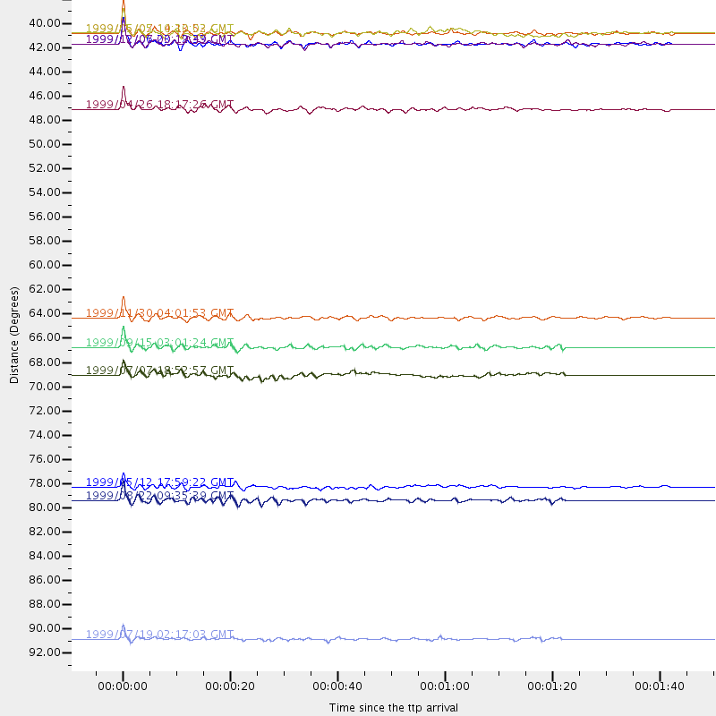
Events Processed for this Station
Download zip of receiver functions as SAC
Plot maxima for each earthquake.
Events Used in the Stack
(11 events)| Radial Match | Distance | Baz | FERegion | Time | Lat/Lon | Depth | Magnitude |
| 94.95771 | 38.1 deg | 318.167 deg | Kodiak Island Region, Alaska | 1999/05/07 14:13:52 GMT | (56.4, -152.9) | 20 km | 5.7 MB, 6.1 MS, 6.4 MW, 5.7 ME |
| 93.82248 | 39.1 deg | 319.444 deg | Kodiak Island Region, Alaska | 1999/12/06 23:12:33 GMT | (57.4, -154.5) | 66 km | 6.8 MB, 7.0 MW, 7.0 ML |
| 92.55317 | 93.5 deg | 237.106 deg | Kermadec Islands Region | 1999/07/19 02:17:03 GMT | (-28.6, -177.6) | 39 km | 6.3 MB, 6.2 MS, 6.4 MW, 6.3 ME |
| 90.57789 | 64.1 deg | 141.795 deg | Northern Chile | 1999/11/30 04:01:53 GMT | (-18.9, -69.2) | 128 km | 6.2 MB, 6.6 MW, 6.5 MW |
| 88.069084 | 38.1 deg | 322.999 deg | Kenai Peninsula, Alaska | 1999/05/05 10:30:03 GMT | (59.3, -151.5) | 71 km | 5.4 MB, 5.8 MW, 5.8 MW |
| 87.95946 | 80.8 deg | 156.984 deg | Off Coast Of Southern Chile | 1999/08/22 09:35:39 GMT | (-40.5, -74.8) | 33 km | 6.2 MB, 5.8 MS, 6.4 MW, 6.2 MW |
| 87.08527 | 79.6 deg | 315.885 deg | Hokkaido, Japan Region | 1999/05/12 17:59:22 GMT | (43.0, 143.8) | 103 km | 5.9 MB, 6.2 MW, 6.1 MW |
| 86.15332 | 66.8 deg | 141.338 deg | Southern Bolivia | 1999/09/15 03:01:24 GMT | (-20.9, -67.3) | 218 km | 6.0 MB, 6.4 MW, 6.4 MW |
| 83.46217 | 45.1 deg | 139.525 deg | Ecuador | 1999/04/26 18:17:26 GMT | (-1.6, -77.8) | 173 km | 5.6 MB, 6.0 MW, 6.0 MW |
| 81.83857 | 39.1 deg | 319.36 deg | Kodiak Island Region, Alaska | 1999/12/07 00:19:49 GMT | (57.4, -154.5) | 41 km | 6.5 MB, 6.1 MS, 6.4 MW, 6.3 ML |
| 81.11368 | 69.3 deg | 316.26 deg | Kuril Islands | 1999/07/07 18:52:57 GMT | (49.2, 155.6) | 33 km | 6.0 MB, 5.6 MS, 6.1 MW, 5.8 ME |
Losers
(0 events)| Radial Match | Distance | Baz | FERegion | Time | Lat/Lon | Depth | Magnitude | Reason |
