
Station XL HFN7 - Harrisburg Flat north 7
Network: XL94 - Southern Seirra - Death Valley
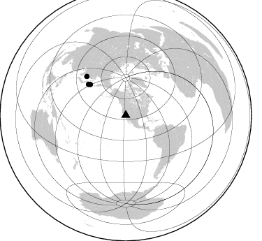
Nearby stations (2 deg radius)
| Station | Name | (Lat, Lon) | Start / End | Elevation |
| HFN7 | Harrisburg Flat north 7 | (36.39, -117.14) | 1994-06-21 / 1994-12-31 | 1516 m |
| Crust2 Type: | M7,medium thick extended crust, 0.5 km seds. |
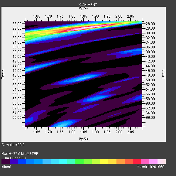
| Thickness Estimate: | 28 km |
| Thickness StdDev: | 0.2 km |
| Vp/Vs Estimate: | 1.87 |
| Vp/Vs StdDev: | 0.01 |
| Vs Estimate: | 3.362 km/s |
| Poisson's Ratio: | 0.30 |
| Peak Value: | 0.10 |
| Assumed Vp: | 6.279 km/s |
| Ps Weight: | 0.33333334 |
| PpPs Weight: | 0.33333334 |
| PsPs Weight: | 0.33333328 |
| Residual Complexity: | 0.513 |
| Nearby stations H: | +- |
| (2.0 deg) Vp/Vs: | +- |
1 with match > 90% ( 8.333333 %) and 3 with match > 80% ( 25.0 %) out of 12.
Download stack as xyz text file.
Azimuth Distribution of Events:
Prior Results for this Station
| Study | Thickness | Vp/Vs | Vp | Vs | Poissons Ratio | Extra |
| EARS | 28 km | 1.87 | 6.279 km/s | 3.362 km/s | 0.30 | |
| Crust2.0 | 35 km | 1.78 | 6.279 km/s | 3.533 km/s | 0.27 | M7,medium thick extended crust, 0.5 km seds. |
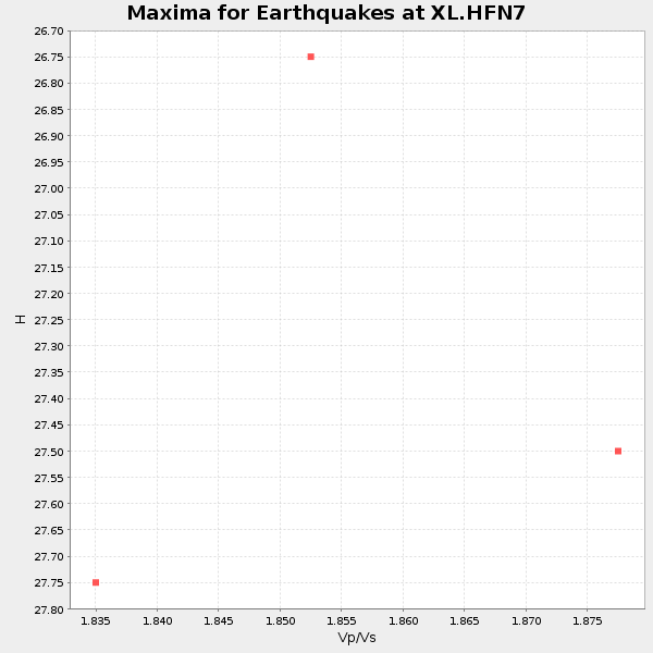
| Global Maxima | 28 km | 1.87 | 6.279 km/s | 3.362 km/s | 0.30 | amp=0.10261958 |
| Local Maxima 1 | 32 km | 1.60 | 6.279 km/s | 3.924 km/s | 0.18 | amp=0.05276029 |
| Local Maxima 2 | 28 km | 1.75 | 6.279 km/s | 3.578 km/s | 0.26 | amp=0.039239887 |
| Local Maxima 3 | 46 km | 1.60 | 6.279 km/s | 3.924 km/s | 0.18 | amp=0.034723245 |
| Local Maxima 4 | 70 km | 1.75 | 6.279 km/s | 3.588 km/s | 0.26 | amp=0.032278612 |
| Predicted Arrivals for vertical incidence (zero ray parameter) | |
| Ps | 3.80 SECOND |
| PpPs | 12.56 SECOND |
| PsPs/PpSs | 16.36 SECOND |
Events Processed for this Station
Download zip of receiver functions as SAC
Plot maxima for each earthquake.
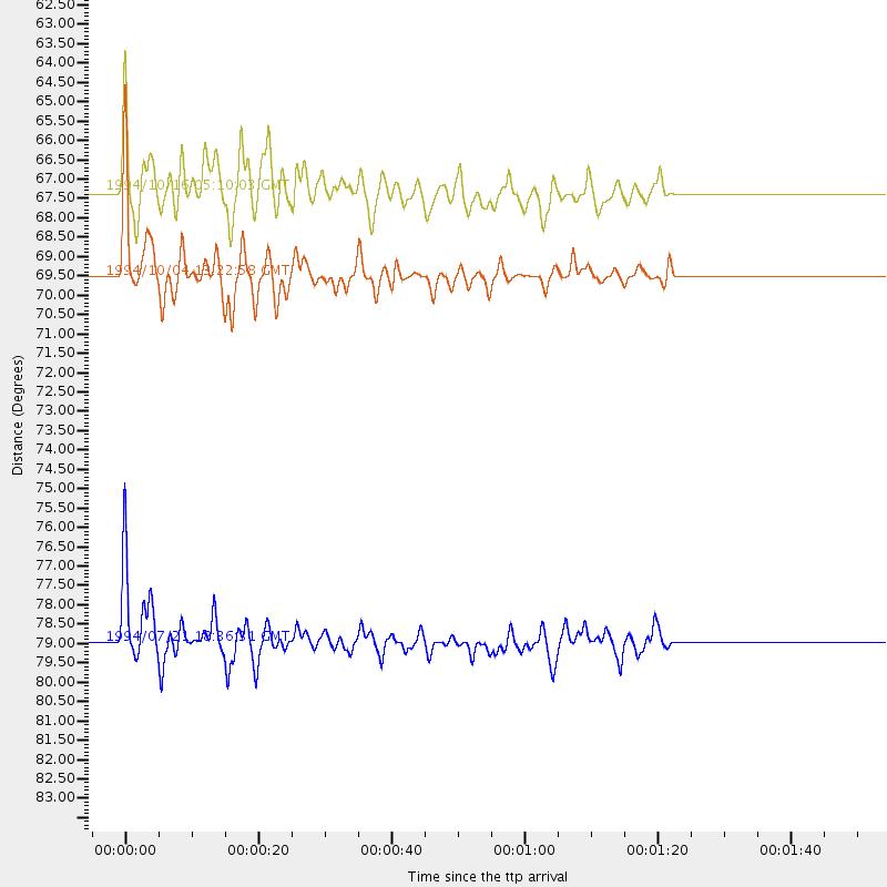
Events Used in the Stack
(3 events)| Radial Match | Distance | Baz | FERegion | Time | Lat/Lon | Depth | Magnitude |
| 95.49437 | 69.5 deg | 309.586 deg | Kuril Islands | 1994/10/04 13:22:58 GMT | (43.7, 147.3) | 33 km | 7.4 MB, 8.1 MS, 8.3 UNKNOWN, 8.2 MW |
| 89.9946 | 78.9 deg | 314.729 deg | Primor'ye, Russia | 1994/07/21 18:36:31 GMT | (42.3, 132.9) | 473 km | 6.4 MB, 7.2 UNKNOWN |
| 81.82959 | 67.3 deg | 310.75 deg | Kuril Islands | 1994/10/16 05:10:03 GMT | (45.7, 149.2) | 139 km | 6.3 MB, 6.8 UNKNOWN, 6.7 MW |
Losers
(9 events)| Radial Match | Distance | Baz | FERegion | Time | Lat/Lon | Depth | Magnitude | Reason |
| 68.79689 | 88.4 deg | 248.112 deg | Vanuatu Islands | 1994/07/13 02:35:55 GMT | (-16.6, 167.5) | 33 km | 6.3 MB, 7.4 MS, 7.3 UNKNOWN, 7.1 MW | |
| 64.524864 | 77.4 deg | 238.774 deg | Fiji Islands Region | 1994/07/05 02:59:42 GMT | (-16.3, -177.5) | 413 km | 5.4 MB, 5.8 UNKNOWN | |
| 61.91653 | 74.4 deg | 164.208 deg | Southern Pacific Ocean | 1994/06/27 04:10:09 GMT | (-36.2, -98.2) | 10 km | 5.5 MB, 5.5 MS | |
| 60.95189 | 86.1 deg | 252.77 deg | Santa Cruz Islands | 1994/08/22 17:26:38 GMT | (-11.5, 166.4) | 148 km | 6.1 MB, 6.4 UNKNOWN, 6.1 MW | |
| 57.807365 | 59.2 deg | 314.729 deg | Near East Coast Of Kamchatka | 1994/08/02 14:17:54 GMT | (52.4, 158.1) | 170 km | 5.8 MB, 5.9 UNKNOWN, 5.8 MW | |
| 55.76033 | 86.8 deg | 239.454 deg | Southeast Of Loyalty Islands | 1994/09/13 12:22:12 GMT | (-22.3, 174.7) | 33 km | 5.5 MB, 5.4 MS | |
| 53.53793 | 88.6 deg | 247.798 deg | Vanuatu Islands | 1994/07/24 17:55:42 GMT | (-17.0, 167.6) | 33 km | 5.6 MB, 6.5 MS, 6.6 UNKNOWN | |
| 53.086067 | 80.6 deg | 132.975 deg | Santiago Del Estero Prov., Arg. | 1994/08/19 10:02:51 GMT | (-26.7, -63.4) | 565 km | 6.4 MB, 6.5 UNKNOWN, 6.5 MW | |
| 46.3069 | 47.0 deg | 118.366 deg | Northern Colombia | 1994/09/13 10:01:34 GMT | (7.1, -76.7) | 33 km | 5.8 MB, 5.6 MS |
