
Station XL S105 - Continental Divide
Network: XL97 - Deep Probe (Archean-Proterozoic)
Nearby stations (2 deg radius)
| Station | Name | (Lat, Lon) | Start / End | Elevation |
| S105 | Continental Divide | (42.06, -108.90) | 1997-05-15 / 1997-12-31 | 2289 m |
| Crust2 Type: | Q0,orogen/46km no ice, Rockies, Tarim Basin, 4 km seds. |
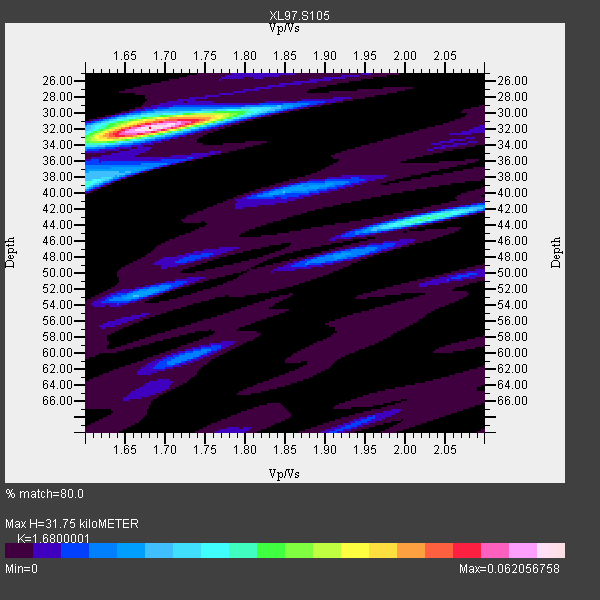
| Thickness Estimate: | 32 km |
| Thickness StdDev: | 1.9 km |
| Vp/Vs Estimate: | 1.68 |
| Vp/Vs StdDev: | 0.04 |
| Vs Estimate: | 3.667 km/s |
| Poisson's Ratio: | 0.23 |
| Peak Value: | 0.06 |
| Assumed Vp: | 6.161 km/s |
| Ps Weight: | 0.33333334 |
| PpPs Weight: | 0.33333334 |
| PsPs Weight: | 0.33333328 |
| Residual Complexity: | 0.431 |
| Nearby stations H: | +- |
| (2.0 deg) Vp/Vs: | +- |
1 with match > 90% ( 7.142857 %) and 5 with match > 80% ( 35.714287 %) out of 14.
Download stack as xyz text file.
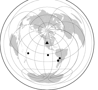
Azimuth Distribution of Events:
Prior Results for this Station
| Study | Thickness | Vp/Vs | Vp | Vs | Poissons Ratio | Extra |
| EARS | 32 km | 1.68 | 6.161 km/s | 3.667 km/s | 0.23 | |
| Crust2.0 | 46 km | 1.75 | 6.161 km/s | 3.511 km/s | 0.26 | Q0,orogen/46km no ice, Rockies, Tarim Basin, 4 km seds. |
| Global Maxima | 32 km | 1.68 | 6.161 km/s | 3.667 km/s | 0.23 | amp=0.062056758 |
| Local Maxima 1 | 43 km | 2.02 | 6.161 km/s | 3.054 km/s | 0.34 | amp=0.027952027 |
| Local Maxima 2 | 39 km | 1.60 | 6.161 km/s | 3.851 km/s | 0.18 | amp=0.025009304 |
| Local Maxima 3 | 31 km | 1.68 | 6.161 km/s | 3.673 km/s | 0.22 | amp=0.02142236 |
| Local Maxima 4 | 40 km | 1.85 | 6.161 km/s | 3.335 km/s | 0.29 | amp=0.015586861 |
| Predicted Arrivals for vertical incidence (zero ray parameter) | |
| Ps | 3.50 SECOND |
| PpPs | 13.81 SECOND |
| PsPs/PpSs | 17.32 SECOND |
Events Processed for this Station
Download zip of receiver functions as SAC
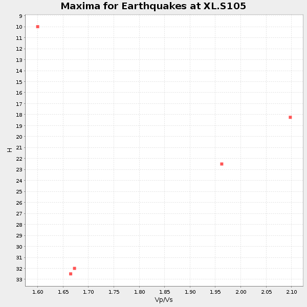
Plot maxima for each earthquake.
Events Used in the Stack
(5 events)| Radial Match | Distance | Baz | FERegion | Time | Lat/Lon | Depth | Magnitude |
| 93.571945 | 46.3 deg | 175.588 deg | Central East Pacific Rise | 1997/08/15 07:37:49 GMT | (-4.4, -105.7) | 10 km | 5.3 MB, 5.8 MS, 6.2 UNKNOWN, 6.1 MW |
| 84.76326 | 79.9 deg | 148.132 deg | Near Coast Of Central Chile | 1997/07/27 05:21:29 GMT | (-30.5, -71.9) | 33 km | 5.6 MB, 5.8 MS, 6.3 UNKNOWN, 6.2 MW |
| 84.57856 | 78.9 deg | 147.419 deg | Near Coast Of Central Chile | 1997/07/19 12:22:57 GMT | (-29.3, -71.7) | 26 km | 5.8 MB, 5.5 MS, 5.9 UNKNOWN, 5.8 MW |
| 84.0004 | 75.8 deg | 139.946 deg | Jujuy Province, Argentina | 1997/07/20 10:14:22 GMT | (-23.0, -66.3) | 256 km | 5.7 MB, 6.1 UNKNOWN, 5.7 ME |
| 82.01136 | 82.2 deg | 241.529 deg | Tonga Islands | 1997/05/27 08:00:29 GMT | (-15.2, -173.3) | 14 km | 5.6 MB, 6.3 MS, 6.4 UNKNOWN, 5.7 ME |
Losers
(9 events)| Radial Match | Distance | Baz | FERegion | Time | Lat/Lon | Depth | Magnitude | Reason |
| 87.34791 | 83.4 deg | 242.948 deg | Tonga Islands | 1997/08/04 18:53:58 GMT | (-15.2, -175.3) | 33 km | 5.5 MB, 6.0 MS, 6.1 UNKNOWN, 6.0 MW | |
| 76.07516 | 87.7 deg | 243.584 deg | Fiji Islands Region | 1997/06/11 11:53:32 GMT | (-17.8, -178.8) | 573 km | 5.5 UNKNOWN, 4.9 MB | |
| 75.108284 | 79.8 deg | 148.141 deg | Near Coast Of Central Chile | 1997/07/25 06:47:02 GMT | (-30.5, -71.9) | 33 km | 5.6 MB, 5.5 MS, 6.3 UNKNOWN | |
| 71.90431 | 40.0 deg | 305.919 deg | Fox Islands, Aleutian Islands | 1997/07/20 00:30:20 GMT | (52.6, -167.5) | 14 km | 5.6 MB, 5.9 MS, 6.2 UNKNOWN, 6.2 MW | |
| 71.53124 | 90.4 deg | 292.398 deg | Mariana Islands | 1997/05/27 15:09:03 GMT | (16.3, 145.4) | 536 km | 5.5 MB, 5.6 UNKNOWN, 5.6 MW | |
| 70.51025 | 91.2 deg | 238.426 deg | South Of Fiji Islands | 1997/06/11 09:29:23 GMT | (-24.0, -177.5) | 164 km | 5.9 UNKNOWN, 5.4 MB, 5.5 MB | |
| 69.78308 | 77.9 deg | 144.667 deg | Northern Chile | 1997/05/17 02:10:18 GMT | (-27.2, -69.5) | 106 km | 5.5 MB, 5.6 UNKNOWN, 5.5 MW | |
| 69.23267 | 47.4 deg | 306.658 deg | Andreanof Islands, Aleutian Is. | 1997/06/17 21:03:40 GMT | (51.3, -179.3) | 33 km | 6.4 MB, 6.3 MS, 6.4 UNKNOWN, 6.6 ML | |
| 61.017265 | 90.2 deg | 38.667 deg | Central Mediterranean Sea | 1997/07/27 10:07:52 GMT | (35.6, 21.1) | 33 km | 5.5 MB, 4.8 MS, 5.6 UNKNOWN, 5.2 ML |
