
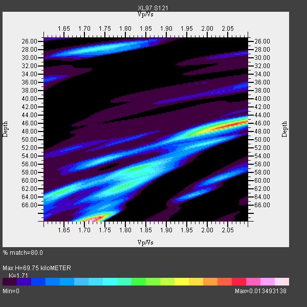
Station XL S121 - Lodore Wildlife Sanctuary
Network: XL97 - Deep Probe (Archean-Proterozoic)
Nearby stations (2 deg radius)
| Station | Name | (Lat, Lon) | Start / End | Elevation |
| S121 | Lodore Wildlife Sanctuary | (40.64, -108.83) | 1997-05-08 / 1997-12-31 | 2011 m |
| Crust2 Type: | Q4,orogen/43km no ice, Tethian Belt, 5 km seds. |
| Thickness Estimate: | 70 km |
| Thickness StdDev: | 11 km |
| Vp/Vs Estimate: | 1.71 |
| Vp/Vs StdDev: | 0.17 |
| Vs Estimate: | 3.63 km/s |
| Poisson's Ratio: | 0.24 |
| Peak Value: | 0.01 |
| Assumed Vp: | 6.207 km/s |
| Ps Weight: | 0.33333334 |
| PpPs Weight: | 0.33333334 |
| PsPs Weight: | 0.33333328 |
| Residual Complexity: | 0.822 |
| Nearby stations H: | +- |
| (2.0 deg) Vp/Vs: | +- |
5 with match > 90% ( 21.73913 %) and 11 with match > 80% ( 47.826088 %) out of 23.
Download stack as xyz text file.
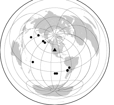
Azimuth Distribution of Events:
Prior Results for this Station
| Study | Thickness | Vp/Vs | Vp | Vs | Poissons Ratio | Extra |
| EARS | 70 km | 1.71 | 6.207 km/s | 3.63 km/s | 0.24 | |
| Crust2.0 | 43 km | 1.76 | 6.207 km/s | 3.535 km/s | 0.26 | Q4,orogen/43km no ice, Tethian Belt, 5 km seds. |
| Global Maxima | 70 km | 1.71 | 6.207 km/s | 3.63 km/s | 0.24 | amp=0.013493138 |
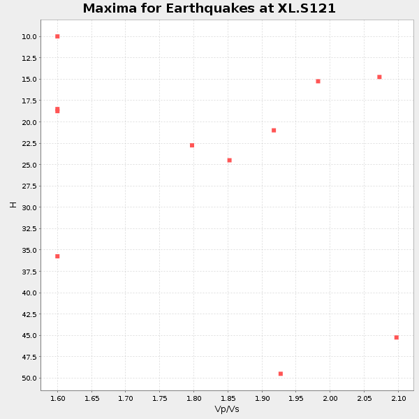
| Local Maxima 1 | 46 km | 2.06 | 6.207 km/s | 3.013 km/s | 0.35 | amp=0.010592426 |
| Local Maxima 2 | 62 km | 1.64 | 6.207 km/s | 3.773 km/s | 0.21 | amp=0.0068739094 |
| Local Maxima 3 | 57 km | 1.82 | 6.207 km/s | 3.406 km/s | 0.28 | amp=0.0059691654 |
| Local Maxima 4 | 28 km | 1.75 | 6.207 km/s | 3.557 km/s | 0.26 | amp=0.0056203566 |
| Predicted Arrivals for vertical incidence (zero ray parameter) | |
| Ps | 7.98 SECOND |
| PpPs | 30.45 SECOND |
| PsPs/PpSs | 38.43 SECOND |
Events Processed for this Station
Download zip of receiver functions as SAC
Plot maxima for each earthquake.
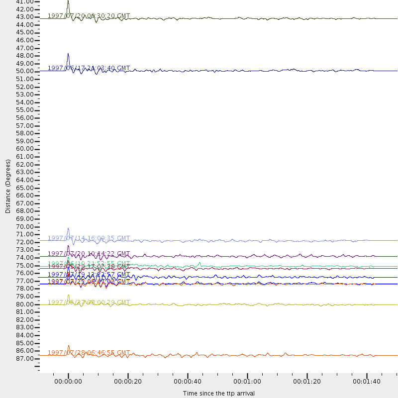
Events Used in the Stack
(11 events)| Radial Match | Distance | Baz | FERegion | Time | Lat/Lon | Depth | Magnitude |
| 96.4683 | 48.3 deg | 307.695 deg | Andreanof Islands, Aleutian Is. | 1997/06/17 21:03:40 GMT | (51.3, -179.3) | 33 km | 6.4 MB, 6.3 MS, 6.4 UNKNOWN, 6.6 ML |
| 95.16301 | 78.7 deg | 148.038 deg | Near Coast Of Central Chile | 1997/07/27 05:21:29 GMT | (-30.5, -71.9) | 33 km | 5.6 MB, 5.8 MS, 6.3 UNKNOWN, 6.2 MW |
| 94.93395 | 40.9 deg | 307.261 deg | Fox Islands, Aleutian Islands | 1997/07/20 00:30:20 GMT | (52.6, -167.5) | 14 km | 5.6 MB, 5.9 MS, 6.2 UNKNOWN, 6.2 MW |
| 93.9671 | 72.5 deg | 312.195 deg | Kuril Islands | 1997/07/14 16:09:35 GMT | (43.2, 146.4) | 33 km | 5.9 MB, 5.8 MS, 6.1 UNKNOWN, 5.8 ME |
| 92.245544 | 76.5 deg | 174.727 deg | Southern Pacific Ocean | 1997/05/29 17:02:38 GMT | (-36.0, -102.5) | 10 km | 5.6 MB, 6.1 MS, 6.5 UNKNOWN, 6.4 MW |
| 89.37998 | 74.6 deg | 139.755 deg | Jujuy Province, Argentina | 1997/07/20 10:14:22 GMT | (-23.0, -66.3) | 256 km | 5.7 MB, 6.1 UNKNOWN, 5.7 ME |
| 86.75769 | 88.7 deg | 298.543 deg | Volcano Islands, Japan Region | 1997/07/28 06:46:55 GMT | (22.4, 142.7) | 33 km | 5.7 MB, 5.8 MS, 5.9 UNKNOWN, 5.9 MW |
| 86.62587 | 78.6 deg | 148.046 deg | Near Coast Of Central Chile | 1997/07/25 06:47:02 GMT | (-30.5, -71.9) | 33 km | 5.6 MB, 5.5 MS, 6.3 UNKNOWN |
| 85.64287 | 76.1 deg | 179.415 deg | Southern East Pacific Rise | 1997/06/10 21:53:55 GMT | (-35.8, -108.1) | 10 km | 5.8 MB, 6.1 MS, 6.5 UNKNOWN, 5.8 MS |
| 84.24508 | 81.5 deg | 241.751 deg | Tonga Islands | 1997/05/27 08:00:29 GMT | (-15.2, -173.3) | 14 km | 5.6 MB, 6.3 MS, 6.4 UNKNOWN, 5.7 ME |
| 81.63465 | 77.6 deg | 147.308 deg | Near Coast Of Central Chile | 1997/07/19 12:22:57 GMT | (-29.3, -71.7) | 26 km | 5.8 MB, 5.5 MS, 5.9 UNKNOWN, 5.8 MW |
Losers
(12 events)| Radial Match | Distance | Baz | FERegion | Time | Lat/Lon | Depth | Magnitude | Reason |
| 62.853996 | 77.3 deg | 170.812 deg | West Chile Rise | 1997/05/11 22:16:13 GMT | (-36.4, -97.7) | 10 km | 5.6 MB, 5.8 MS, 6.5 UNKNOWN, 6.4 MW | |
| 60.767365 | 91.0 deg | 292.424 deg | Mariana Islands | 1997/05/27 15:09:03 GMT | (16.3, 145.4) | 536 km | 5.5 MB, 5.6 UNKNOWN, 5.6 MW | |
| 60.643227 | 79.7 deg | 310.314 deg | Eastern Honshu, Japan | 1997/05/11 22:59:38 GMT | (37.1, 140.9) | 49 km | 5.5 MB, 5.3 MS | |
| 59.795574 | 91.3 deg | 38.719 deg | Central Mediterranean Sea | 1997/07/27 10:07:52 GMT | (35.6, 21.1) | 33 km | 5.5 MB, 4.8 MS, 5.6 UNKNOWN, 5.2 ML | |
| 57.664722 | 97.3 deg | 311.796 deg | Southwestern Ryukyu Isl., Japan | 1997/08/13 04:45:04 GMT | (25.0, 125.8) | 55 km | 6.0 MB, 5.6 MS, 6.1 UNKNOWN, 6.1 MW | |
| 49.96921 | 93.9 deg | 246.101 deg | Vanuatu Islands Region | 1997/06/24 16:17:09 GMT | (-20.7, 174.2) | 33 km | 5.5 MS, 5.2 MB, 5.9 UNKNOWN, 5.9 MW | |
| 44.971176 | 93.6 deg | 290.635 deg | Mariana Islands | 1997/05/09 09:06:37 GMT | (13.2, 144.7) | 29 km | 5.9 MB, 5.8 MS, 6.0 UNKNOWN, 6.0 ME | |
| 41.295753 | 90.1 deg | 183.721 deg | Southern East Pacific Rise | 1997/06/26 19:21:08 GMT | (-49.7, -114.6) | 10 km | 5.4 MB, 6.0 MS, 6.2 UNKNOWN, 6.1 MW | |
| 41.06076 | 97.1 deg | 249.338 deg | Vanuatu Islands | 1997/05/21 14:10:26 GMT | (-20.4, 169.3) | 57 km | 5.9 MB, 6.5 MS, 6.7 UNKNOWN, 6.1 ME | |
| 39.716496 | 86.9 deg | 313.917 deg | Western Honshu, Japan | 1997/06/25 09:50:12 GMT | (34.4, 131.6) | 10 km | 5.5 MB, 5.6 MS, 5.9 UNKNOWN, 5.8 MW | |
| 29.630169 | 90.5 deg | 238.448 deg | South Of Fiji Islands | 1997/06/11 09:29:23 GMT | (-24.0, -177.5) | 164 km | 5.9 UNKNOWN, 5.4 MB, 5.5 MB | |
| 20.93269 | 87.1 deg | 243.683 deg | Fiji Islands Region | 1997/06/11 11:53:32 GMT | (-17.8, -178.8) | 573 km | 5.5 UNKNOWN, 4.9 MB |
