
Station XL S132 - Foundation Creek
Network: XL97 - Deep Probe (Archean-Proterozoic)
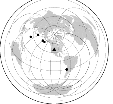
Nearby stations (2 deg radius)
| Station | Name | (Lat, Lon) | Start / End | Elevation |
| S132 | Foundation Creek | (39.68, -108.79) | 1997-05-11 / 1997-12-31 | 2169 m |
| Crust2 Type: | Q3,orogen/43km no ice, Appalachians, 3 km seds. |
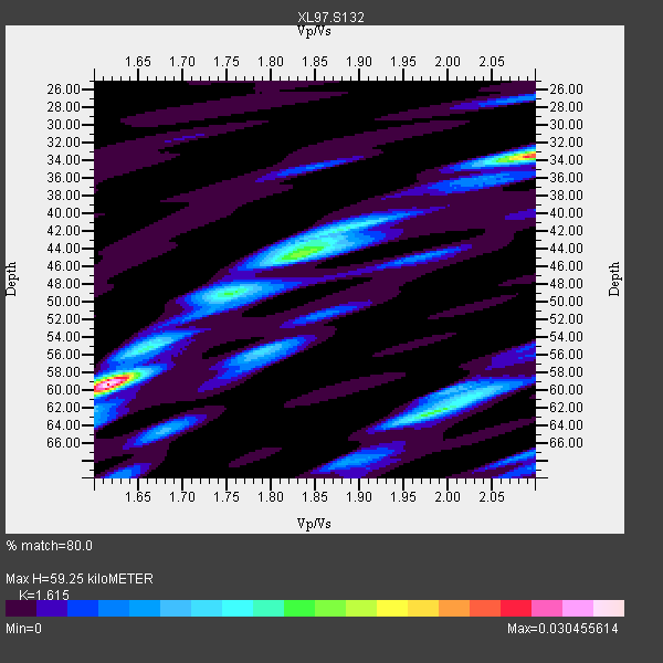
| Thickness Estimate: | 59 km |
| Thickness StdDev: | 11 km |
| Vp/Vs Estimate: | 1.62 |
| Vp/Vs StdDev: | 0.20 |
| Vs Estimate: | 3.895 km/s |
| Poisson's Ratio: | 0.19 |
| Peak Value: | 0.03 |
| Assumed Vp: | 6.291 km/s |
| Ps Weight: | 0.33333334 |
| PpPs Weight: | 0.33333334 |
| PsPs Weight: | 0.33333328 |
| Residual Complexity: | 0.726 |
| Nearby stations H: | +- |
| (2.0 deg) Vp/Vs: | +- |
5 with match > 90% ( 31.25 %) and 10 with match > 80% ( 62.5 %) out of 16.
Download stack as xyz text file.
Azimuth Distribution of Events:
Prior Results for this Station
| Study | Thickness | Vp/Vs | Vp | Vs | Poissons Ratio | Extra |
| EARS | 59 km | 1.62 | 6.291 km/s | 3.895 km/s | 0.19 | |
| Crust2.0 | 43 km | 1.76 | 6.291 km/s | 3.577 km/s | 0.26 | Q3,orogen/43km no ice, Appalachians, 3 km seds. |
| Global Maxima | 59 km | 1.62 | 6.291 km/s | 3.895 km/s | 0.19 | amp=0.030455614 |
| Local Maxima 1 | 34 km | 2.09 | 6.291 km/s | 3.014 km/s | 0.35 | amp=0.019175366 |
| Local Maxima 2 | 62 km | 1.98 | 6.291 km/s | 3.177 km/s | 0.33 | amp=0.015099749 |
| Local Maxima 3 | 44 km | 1.84 | 6.291 km/s | 3.428 km/s | 0.29 | amp=0.014471736 |
| Local Maxima 4 | 49 km | 1.75 | 6.291 km/s | 3.6 km/s | 0.26 | amp=0.009974686 |
| Predicted Arrivals for vertical incidence (zero ray parameter) | |
| Ps | 5.79 SECOND |
| PpPs | 24.63 SECOND |
| PsPs/PpSs | 30.42 SECOND |
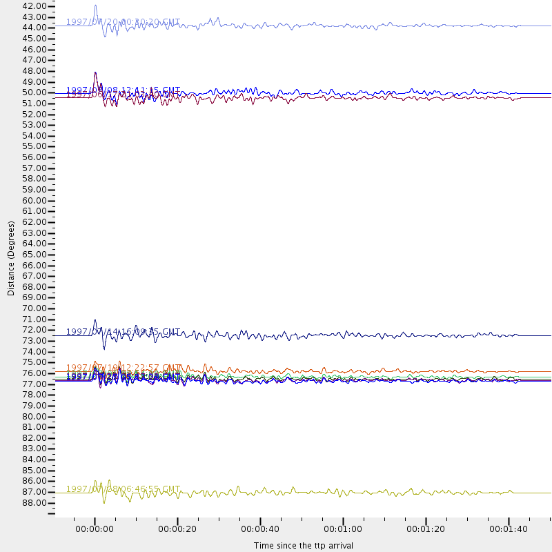
Events Processed for this Station
Download zip of receiver functions as SAC
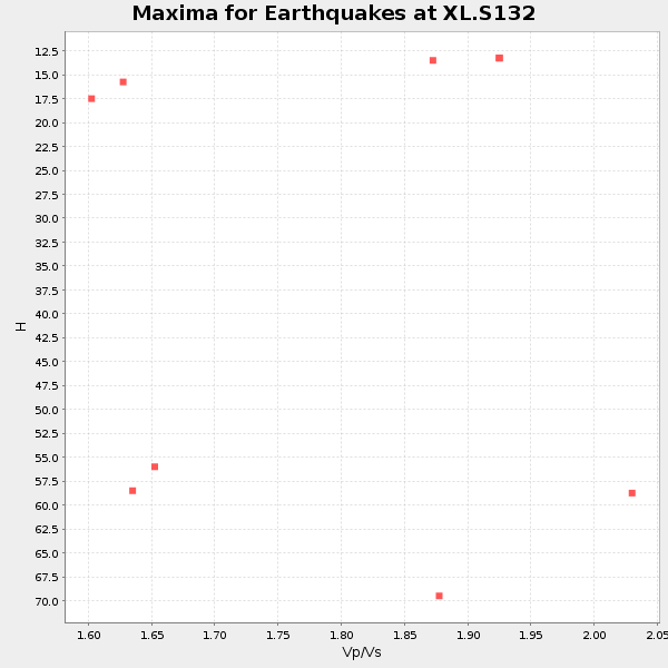
Plot maxima for each earthquake.
Events Used in the Stack
(10 events)| Radial Match | Distance | Baz | FERegion | Time | Lat/Lon | Depth | Magnitude |
| 91.9425 | 76.8 deg | 147.225 deg | Near Coast Of Central Chile | 1997/07/19 12:22:57 GMT | (-29.3, -71.7) | 26 km | 5.8 MB, 5.5 MS, 5.9 UNKNOWN, 5.8 MW |
| 91.6811 | 48.5 deg | 308.245 deg | Andreanof Islands, Aleutian Is. | 1997/07/08 12:11:15 GMT | (51.4, -178.6) | 33 km | 5.5 MB, 5.4 MS, 5.8 UNKNOWN, 5.6 ML |
| 91.55775 | 77.8 deg | 147.966 deg | Near Coast Of Central Chile | 1997/07/27 05:21:29 GMT | (-30.5, -71.9) | 33 km | 5.6 MB, 5.8 MS, 6.3 UNKNOWN, 6.2 MW |
| 90.321495 | 77.4 deg | 147.751 deg | Near Coast Of Central Chile | 1997/07/06 09:54:00 GMT | (-30.1, -71.9) | 19 km | 5.8 MB, 6.5 MS, 6.8 UNKNOWN, 6.4 ME |
| 90.01713 | 41.5 deg | 308.138 deg | Fox Islands, Aleutian Islands | 1997/07/20 00:30:20 GMT | (52.6, -167.5) | 14 km | 5.6 MB, 5.9 MS, 6.2 UNKNOWN, 6.2 MW |
| 89.64336 | 89.2 deg | 298.587 deg | Volcano Islands, Japan Region | 1997/07/28 06:46:55 GMT | (22.4, 142.7) | 33 km | 5.7 MB, 5.8 MS, 5.9 UNKNOWN, 5.9 MW |
| 88.40438 | 77.6 deg | 147.917 deg | Near Coast Of Central Chile | 1997/07/21 23:19:39 GMT | (-30.3, -71.9) | 33 km | 5.2 MB, 5.5 MS, 6.1 UNKNOWN |
| 86.66884 | 77.7 deg | 147.973 deg | Near Coast Of Central Chile | 1997/07/25 06:47:02 GMT | (-30.5, -71.9) | 33 km | 5.6 MB, 5.5 MS, 6.3 UNKNOWN |
| 84.07145 | 73.2 deg | 312.438 deg | Kuril Islands | 1997/07/14 16:09:35 GMT | (43.2, 146.4) | 33 km | 5.9 MB, 5.8 MS, 6.1 UNKNOWN, 5.8 ME |
| 83.370514 | 49.0 deg | 308.375 deg | Andreanof Islands, Aleutian Is. | 1997/06/17 21:03:40 GMT | (51.3, -179.3) | 33 km | 6.4 MB, 6.3 MS, 6.4 UNKNOWN, 6.6 ML |
Losers
(6 events)| Radial Match | Distance | Baz | FERegion | Time | Lat/Lon | Depth | Magnitude | Reason |
| 88.261246 | 88.2 deg | 299.662 deg | Volcano Islands, Japan Region | 1997/07/08 02:24:07 GMT | (23.8, 142.7) | 33 km | 5.8 MB, 5.6 MS, 5.9 UNKNOWN, 5.8 MW | |
| 87.45864 | 91.4 deg | 292.435 deg | Mariana Islands | 1997/05/27 15:09:03 GMT | (16.3, 145.4) | 536 km | 5.5 MB, 5.6 UNKNOWN, 5.6 MW | |
| 75.90326 | 81.1 deg | 241.913 deg | Tonga Islands | 1997/05/27 08:00:29 GMT | (-15.2, -173.3) | 14 km | 5.6 MB, 6.3 MS, 6.4 UNKNOWN, 5.7 ME | |
| 74.12467 | 86.7 deg | 243.76 deg | Fiji Islands Region | 1997/06/11 11:53:32 GMT | (-17.8, -178.8) | 573 km | 5.5 UNKNOWN, 4.9 MB | |
| 71.08437 | 92.0 deg | 38.766 deg | Central Mediterranean Sea | 1997/07/27 10:07:52 GMT | (35.6, 21.1) | 33 km | 5.5 MB, 4.8 MS, 5.6 UNKNOWN, 5.2 ML | |
| 64.38517 | 90.0 deg | 238.473 deg | South Of Fiji Islands | 1997/06/11 09:29:23 GMT | (-24.0, -177.5) | 164 km | 5.9 UNKNOWN, 5.4 MB, 5.5 MB |
