
Station XL S135 - Young Ranch
Network: XL97 - Deep Probe (Archean-Proterozoic)
Nearby stations (2 deg radius)
| Station | Name | (Lat, Lon) | Start / End | Elevation |
| S135 | Young Ranch | (39.40, -108.82) | 1997-05-08 / 1997-12-31 | 1554 m |
| Crust2 Type: | Q3,orogen/43km no ice, Appalachians, 3 km seds. |
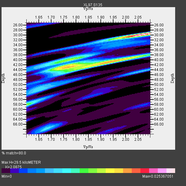
| Thickness Estimate: | 30 km |
| Thickness StdDev: | 8.2 km |
| Vp/Vs Estimate: | 2.09 |
| Vp/Vs StdDev: | 0.17 |
| Vs Estimate: | 3.014 km/s |
| Poisson's Ratio: | 0.35 |
| Peak Value: | 0.03 |
| Assumed Vp: | 6.291 km/s |
| Ps Weight: | 0.33333334 |
| PpPs Weight: | 0.33333334 |
| PsPs Weight: | 0.33333328 |
| Residual Complexity: | 0.837 |
| Nearby stations H: | +- |
| (2.0 deg) Vp/Vs: | +- |
3 with match > 90% ( 12.5 %) and 8 with match > 80% ( 33.333332 %) out of 24.
Download stack as xyz text file.
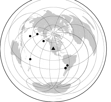
Azimuth Distribution of Events:
Prior Results for this Station
| Study | Thickness | Vp/Vs | Vp | Vs | Poissons Ratio | Extra |
| EARS | 30 km | 2.09 | 6.291 km/s | 3.014 km/s | 0.35 | |
| Crust2.0 | 43 km | 1.76 | 6.291 km/s | 3.577 km/s | 0.26 | Q3,orogen/43km no ice, Appalachians, 3 km seds. |
| Global Maxima | 30 km | 2.09 | 6.291 km/s | 3.014 km/s | 0.35 | amp=0.025367051 |
| Local Maxima 1 | 41 km | 1.93 | 6.291 km/s | 3.251 km/s | 0.32 | amp=0.018541442 |
| Local Maxima 2 | 42 km | 1.79 | 6.291 km/s | 3.524 km/s | 0.27 | amp=0.016287833 |
| Local Maxima 3 | 58 km | 1.60 | 6.291 km/s | 3.932 km/s | 0.18 | amp=0.0146113215 |
| Local Maxima 4 | 40 km | 1.74 | 6.291 km/s | 3.615 km/s | 0.25 | amp=0.010398721 |
| Predicted Arrivals for vertical incidence (zero ray parameter) | |
| Ps | 5.10 SECOND |
| PpPs | 14.48 SECOND |
| PsPs/PpSs | 19.58 SECOND |
Events Processed for this Station
Download zip of receiver functions as SAC
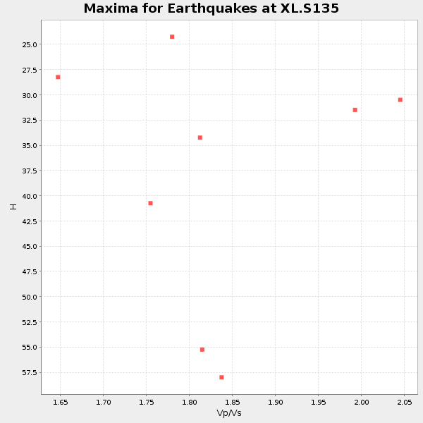
Plot maxima for each earthquake.
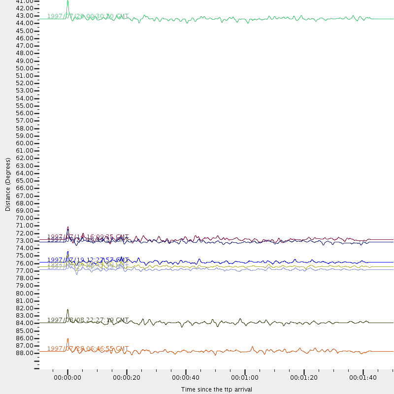
Events Used in the Stack
(8 events)| Radial Match | Distance | Baz | FERegion | Time | Lat/Lon | Depth | Magnitude |
| 94.17921 | 77.2 deg | 147.697 deg | Near Coast Of Central Chile | 1997/07/06 09:54:00 GMT | (-30.1, -71.9) | 19 km | 5.8 MB, 6.5 MS, 6.8 UNKNOWN, 6.4 ME |
| 94.03097 | 77.6 deg | 147.913 deg | Near Coast Of Central Chile | 1997/07/27 05:21:29 GMT | (-30.5, -71.9) | 33 km | 5.6 MB, 5.8 MS, 6.3 UNKNOWN, 6.2 MW |
| 91.66793 | 85.2 deg | 245.659 deg | Fiji Islands Region | 1997/08/08 22:27:19 GMT | (-15.5, -179.1) | 10 km | 5.7 MB, 6.6 MS, 6.6 UNKNOWN, 6.4 MW |
| 85.321846 | 76.6 deg | 147.169 deg | Near Coast Of Central Chile | 1997/07/19 12:22:57 GMT | (-29.3, -71.7) | 26 km | 5.8 MB, 5.5 MS, 5.9 UNKNOWN, 5.8 MW |
| 84.3817 | 89.3 deg | 298.574 deg | Volcano Islands, Japan Region | 1997/07/28 06:46:55 GMT | (22.4, 142.7) | 33 km | 5.7 MB, 5.8 MS, 5.9 UNKNOWN, 5.9 MW |
| 83.625595 | 41.7 deg | 308.378 deg | Fox Islands, Aleutian Islands | 1997/07/20 00:30:20 GMT | (52.6, -167.5) | 14 km | 5.6 MB, 5.9 MS, 6.2 UNKNOWN, 6.2 MW |
| 82.50893 | 73.7 deg | 139.541 deg | Jujuy Province, Argentina | 1997/07/20 10:14:22 GMT | (-23.0, -66.3) | 256 km | 5.7 MB, 6.1 UNKNOWN, 5.7 ME |
| 82.431915 | 73.3 deg | 312.486 deg | Kuril Islands | 1997/07/14 16:09:35 GMT | (43.2, 146.4) | 33 km | 5.9 MB, 5.8 MS, 6.1 UNKNOWN, 5.8 ME |
Losers
(16 events)| Radial Match | Distance | Baz | FERegion | Time | Lat/Lon | Depth | Magnitude | Reason |
| 79.35502 | 77.5 deg | 147.921 deg | Near Coast Of Central Chile | 1997/07/25 06:47:02 GMT | (-30.5, -71.9) | 33 km | 5.6 MB, 5.5 MS, 6.3 UNKNOWN | |
| 78.96001 | 61.7 deg | 62.213 deg | Azores Islands, Portugal | 1997/06/27 04:39:52 GMT | (38.3, -26.7) | 10 km | 5.6 MB, 5.4 MS, 5.9 UNKNOWN, 5.9 MW | |
| 77.908394 | 88.4 deg | 299.652 deg | Volcano Islands, Japan Region | 1997/07/08 02:24:07 GMT | (23.8, 142.7) | 33 km | 5.8 MB, 5.6 MS, 5.9 UNKNOWN, 5.8 MW | |
| 73.96794 | 48.7 deg | 308.429 deg | Andreanof Islands, Aleutian Is. | 1997/07/08 12:11:15 GMT | (51.4, -178.6) | 33 km | 5.5 MB, 5.4 MS, 5.8 UNKNOWN, 5.6 ML | |
| 72.601845 | 74.8 deg | 179.426 deg | Southern East Pacific Rise | 1997/06/10 21:53:55 GMT | (-35.8, -108.1) | 10 km | 5.8 MB, 6.1 MS, 6.5 UNKNOWN, 5.8 MS | |
| 70.915886 | 81.0 deg | 241.932 deg | Tonga Islands | 1997/05/27 08:00:29 GMT | (-15.2, -173.3) | 14 km | 5.6 MB, 6.3 MS, 6.4 UNKNOWN, 5.7 ME | |
| 65.495804 | 92.2 deg | 38.755 deg | Central Mediterranean Sea | 1997/07/27 10:07:52 GMT | (35.6, 21.1) | 33 km | 5.5 MB, 4.8 MS, 5.6 UNKNOWN, 5.2 ML | |
| 61.924335 | 76.1 deg | 170.78 deg | West Chile Rise | 1997/05/11 22:16:13 GMT | (-36.4, -97.7) | 10 km | 5.6 MB, 5.8 MS, 6.5 UNKNOWN, 6.4 MW | |
| 55.452633 | 96.7 deg | 249.208 deg | Vanuatu Islands | 1997/05/21 14:10:26 GMT | (-20.4, 169.3) | 57 km | 5.9 MB, 6.5 MS, 6.7 UNKNOWN, 6.1 ME | |
| 55.35604 | 87.8 deg | 313.97 deg | Western Honshu, Japan | 1997/06/25 09:50:12 GMT | (34.4, 131.6) | 10 km | 5.5 MB, 5.6 MS, 5.9 UNKNOWN, 5.8 MW | |
| 54.66103 | 88.9 deg | 183.734 deg | Southern East Pacific Rise | 1997/06/26 19:21:08 GMT | (-49.7, -114.6) | 10 km | 5.4 MB, 6.0 MS, 6.2 UNKNOWN, 6.1 MW | |
| 53.182938 | 49.1 deg | 308.555 deg | Andreanof Islands, Aleutian Is. | 1997/06/17 21:03:40 GMT | (51.3, -179.3) | 33 km | 6.4 MB, 6.3 MS, 6.4 UNKNOWN, 6.6 ML | |
| 48.868046 | 75.7 deg | 144.369 deg | Northern Chile | 1997/05/17 02:10:18 GMT | (-27.2, -69.5) | 106 km | 5.5 MB, 5.6 UNKNOWN, 5.5 MW | |
| 41.23592 | 86.6 deg | 243.757 deg | Fiji Islands Region | 1997/06/11 11:53:32 GMT | (-17.8, -178.8) | 573 km | 5.5 UNKNOWN, 4.9 MB | |
| 40.725075 | 89.9 deg | 238.456 deg | South Of Fiji Islands | 1997/06/11 09:29:23 GMT | (-24.0, -177.5) | 164 km | 5.9 UNKNOWN, 5.4 MB, 5.5 MB | |
| 29.671307 | 91.4 deg | 292.411 deg | Mariana Islands | 1997/05/27 15:09:03 GMT | (16.3, 145.4) | 536 km | 5.5 MB, 5.6 UNKNOWN, 5.6 MW |
