
Station XL S140 - South Glade Park
Network: XL97 - Deep Probe (Archean-Proterozoic)
Nearby stations (2 deg radius)
| Station | Name | (Lat, Lon) | Start / End | Elevation |
| S140 | South Glade Park | (38.95, -108.74) | 1997-05-31 / 1997-12-31 | 2244 m |
| Crust2 Type: | Q3,orogen/43km no ice, Appalachians, 3 km seds. |
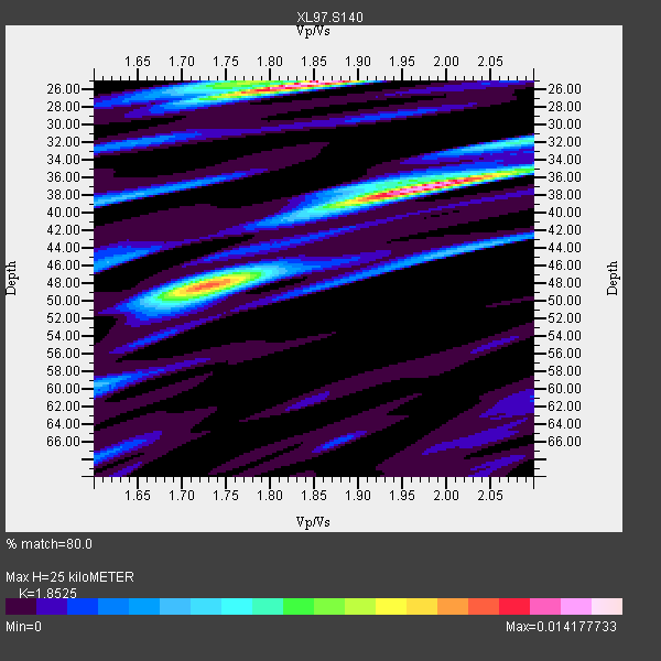
| Thickness Estimate: | 25 km |
| Thickness StdDev: | 8.1 km |
| Vp/Vs Estimate: | 1.85 |
| Vp/Vs StdDev: | 0.09 |
| Vs Estimate: | 3.396 km/s |
| Poisson's Ratio: | 0.29 |
| Peak Value: | 0.01 |
| Assumed Vp: | 6.291 km/s |
| Ps Weight: | 0.33333334 |
| PpPs Weight: | 0.33333334 |
| PsPs Weight: | 0.33333328 |
| Residual Complexity: | 0.852 |
| Nearby stations H: | +- |
| (2.0 deg) Vp/Vs: | +- |
10 with match > 90% ( 52.63158 %) and 11 with match > 80% ( 57.894737 %) out of 19.
Download stack as xyz text file.
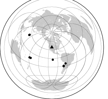
Azimuth Distribution of Events:
Prior Results for this Station
| Study | Thickness | Vp/Vs | Vp | Vs | Poissons Ratio | Extra |
| EARS | 25 km | 1.85 | 6.291 km/s | 3.396 km/s | 0.29 | |
| Crust2.0 | 43 km | 1.76 | 6.291 km/s | 3.577 km/s | 0.26 | Q3,orogen/43km no ice, Appalachians, 3 km seds. |
| Global Maxima | 25 km | 1.85 | 6.291 km/s | 3.396 km/s | 0.29 | amp=0.014177733 |
| Local Maxima 1 | 37 km | 1.98 | 6.291 km/s | 3.185 km/s | 0.33 | amp=0.01339858 |
| Local Maxima 2 | 48 km | 1.72 | 6.291 km/s | 3.652 km/s | 0.25 | amp=0.009698186 |
| Local Maxima 3 | 32 km | 2.07 | 6.291 km/s | 3.039 km/s | 0.35 | amp=0.003836149 |
| Local Maxima 4 | 38 km | 1.63 | 6.291 km/s | 3.859 km/s | 0.20 | amp=0.0035403285 |
| Predicted Arrivals for vertical incidence (zero ray parameter) | |
| Ps | 3.39 SECOND |
| PpPs | 11.34 SECOND |
| PsPs/PpSs | 14.72 SECOND |
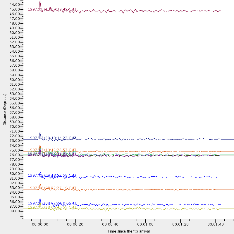
Events Processed for this Station
Download zip of receiver functions as SAC
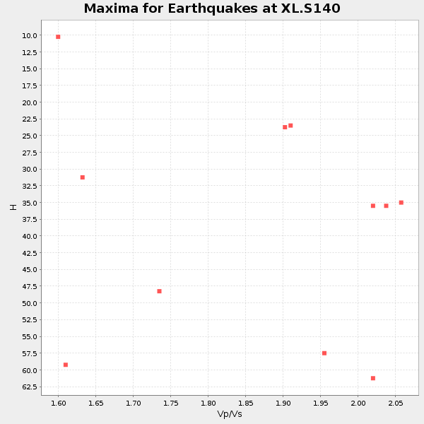
Plot maxima for each earthquake.
Events Used in the Stack
(11 events)| Radial Match | Distance | Baz | FERegion | Time | Lat/Lon | Depth | Magnitude |
| 96.517815 | 77.2 deg | 147.92 deg | Near Coast Of Central Chile | 1997/07/27 05:21:29 GMT | (-30.5, -71.9) | 33 km | 5.6 MB, 5.8 MS, 6.3 UNKNOWN, 6.2 MW |
| 95.99683 | 76.2 deg | 147.171 deg | Near Coast Of Central Chile | 1997/07/19 12:22:57 GMT | (-29.3, -71.7) | 26 km | 5.8 MB, 5.5 MS, 5.9 UNKNOWN, 5.8 MW |
| 95.43086 | 76.8 deg | 147.702 deg | Near Coast Of Central Chile | 1997/07/06 09:54:00 GMT | (-30.1, -71.9) | 19 km | 5.8 MB, 6.5 MS, 6.8 UNKNOWN, 6.4 ME |
| 94.90241 | 77.1 deg | 147.927 deg | Near Coast Of Central Chile | 1997/07/25 06:47:02 GMT | (-30.5, -71.9) | 33 km | 5.6 MB, 5.5 MS, 6.3 UNKNOWN |
| 94.48573 | 73.3 deg | 139.517 deg | Jujuy Province, Argentina | 1997/07/20 10:14:22 GMT | (-23.0, -66.3) | 256 km | 5.7 MB, 6.1 UNKNOWN, 5.7 ME |
| 93.46274 | 82.1 deg | 243.41 deg | Tonga Islands | 1997/08/04 18:53:58 GMT | (-15.2, -175.3) | 33 km | 5.5 MB, 6.0 MS, 6.1 UNKNOWN, 6.0 MW |
| 93.03603 | 77.0 deg | 147.87 deg | Near Coast Of Central Chile | 1997/07/21 23:19:39 GMT | (-30.3, -71.9) | 33 km | 5.2 MB, 5.5 MS, 6.1 UNKNOWN |
| 92.90729 | 85.1 deg | 245.745 deg | Fiji Islands Region | 1997/08/08 22:27:19 GMT | (-15.5, -179.1) | 10 km | 5.7 MB, 6.6 MS, 6.6 UNKNOWN, 6.4 MW |
| 91.68077 | 43.2 deg | 175.569 deg | Central East Pacific Rise | 1997/08/15 07:37:49 GMT | (-4.4, -105.7) | 10 km | 5.3 MB, 5.8 MS, 6.2 UNKNOWN, 6.1 MW |
| 90.47193 | 88.6 deg | 299.711 deg | Volcano Islands, Japan Region | 1997/07/08 02:24:07 GMT | (23.8, 142.7) | 33 km | 5.8 MB, 5.6 MS, 5.9 UNKNOWN, 5.8 MW |
| 86.964226 | 89.6 deg | 298.626 deg | Volcano Islands, Japan Region | 1997/07/28 06:46:55 GMT | (22.4, 142.7) | 33 km | 5.7 MB, 5.8 MS, 5.9 UNKNOWN, 5.9 MW |
Losers
(8 events)| Radial Match | Distance | Baz | FERegion | Time | Lat/Lon | Depth | Magnitude | Reason |
| 75.726036 | 88.1 deg | 314.03 deg | Western Honshu, Japan | 1997/06/25 09:50:12 GMT | (34.4, 131.6) | 10 km | 5.5 MB, 5.6 MS, 5.9 UNKNOWN, 5.8 MW | |
| 74.332794 | 42.0 deg | 308.781 deg | Fox Islands, Aleutian Islands | 1997/07/20 00:30:20 GMT | (52.6, -167.5) | 14 km | 5.6 MB, 5.9 MS, 6.2 UNKNOWN, 6.2 MW | |
| 72.54509 | 49.0 deg | 308.755 deg | Andreanof Islands, Aleutian Is. | 1997/07/08 12:11:15 GMT | (51.4, -178.6) | 33 km | 5.5 MB, 5.4 MS, 5.8 UNKNOWN, 5.6 ML | |
| 70.788765 | 86.4 deg | 243.832 deg | Fiji Islands Region | 1997/06/11 11:53:32 GMT | (-17.8, -178.8) | 573 km | 5.5 UNKNOWN, 4.9 MB | |
| 67.10471 | 49.4 deg | 308.877 deg | Andreanof Islands, Aleutian Is. | 1997/06/17 21:03:40 GMT | (51.3, -179.3) | 33 km | 6.4 MB, 6.3 MS, 6.4 UNKNOWN, 6.6 ML | |
| 65.88785 | 92.5 deg | 38.818 deg | Central Mediterranean Sea | 1997/07/27 10:07:52 GMT | (35.6, 21.1) | 33 km | 5.5 MB, 4.8 MS, 5.6 UNKNOWN, 5.2 ML | |
| 64.825745 | 89.7 deg | 238.507 deg | South Of Fiji Islands | 1997/06/11 09:29:23 GMT | (-24.0, -177.5) | 164 km | 5.9 UNKNOWN, 5.4 MB, 5.5 MB | |
| 59.677097 | 73.7 deg | 312.622 deg | Kuril Islands | 1997/07/14 16:09:35 GMT | (43.2, 146.4) | 33 km | 5.9 MB, 5.8 MS, 6.1 UNKNOWN, 5.8 ME |
