
Station XL S205 - The Hogsback
Network: XL97 - Deep Probe (Archean-Proterozoic)
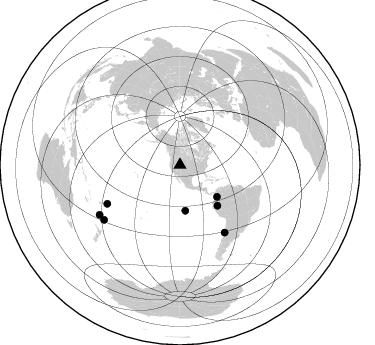
Nearby stations (2 deg radius)
| Station | Name | (Lat, Lon) | Start / End | Elevation |
| S205 | The Hogsback | (41.57, -110.51) | 1997-08-13 / 1997-12-31 | 1983 m |
| Crust2 Type: | M2,extended crust, 2 km seds. |
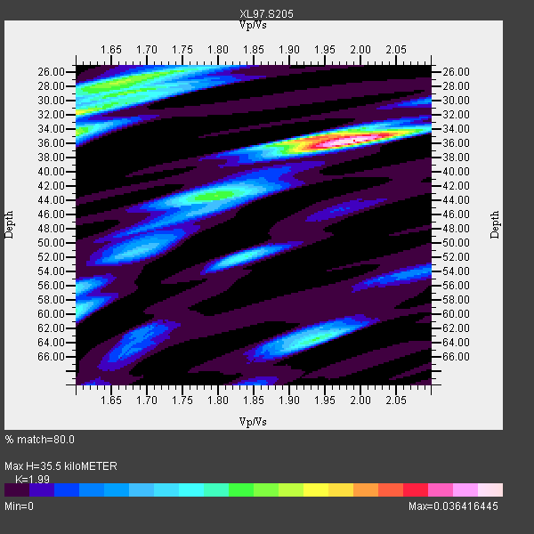
| Thickness Estimate: | 36 km |
| Thickness StdDev: | 3.8 km |
| Vp/Vs Estimate: | 1.99 |
| Vp/Vs StdDev: | 0.18 |
| Vs Estimate: | 3.093 km/s |
| Poisson's Ratio: | 0.33 |
| Peak Value: | 0.04 |
| Assumed Vp: | 6.155 km/s |
| Ps Weight: | 0.33333334 |
| PpPs Weight: | 0.33333334 |
| PsPs Weight: | 0.33333328 |
| Residual Complexity: | 0.713 |
| Nearby stations H: | +- |
| (2.0 deg) Vp/Vs: | +- |
4 with match > 90% ( 20.0 %) and 7 with match > 80% ( 35.0 %) out of 20.
Download stack as xyz text file.
Azimuth Distribution of Events:
Prior Results for this Station
| Study | Thickness | Vp/Vs | Vp | Vs | Poissons Ratio | Extra |
| EARS | 36 km | 1.99 | 6.155 km/s | 3.093 km/s | 0.33 | |
| Crust2.0 | 31 km | 1.78 | 6.155 km/s | 3.458 km/s | 0.27 | M2,extended crust, 2 km seds. |
| Global Maxima | 36 km | 1.99 | 6.155 km/s | 3.093 km/s | 0.33 | amp=0.036416445 |
| Local Maxima 1 | 32 km | 1.60 | 6.155 km/s | 3.847 km/s | 0.18 | amp=0.023726117 |
| Local Maxima 2 | 35 km | 1.92 | 6.155 km/s | 3.201 km/s | 0.31 | amp=0.021423653 |
| Local Maxima 3 | 26 km | 1.70 | 6.155 km/s | 3.615 km/s | 0.24 | amp=0.01895561 |
| Local Maxima 4 | 34 km | 1.60 | 6.155 km/s | 3.847 km/s | 0.18 | amp=0.017358776 |
| Predicted Arrivals for vertical incidence (zero ray parameter) | |
| Ps | 5.71 SECOND |
| PpPs | 17.25 SECOND |
| PsPs/PpSs | 22.96 SECOND |
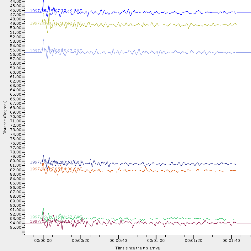
Events Processed for this Station
Download zip of receiver functions as SAC
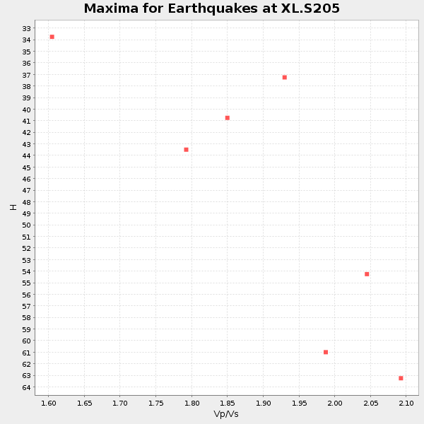
Plot maxima for each earthquake.
Events Used in the Stack
(7 events)| Radial Match | Distance | Baz | FERegion | Time | Lat/Lon | Depth | Magnitude |
| 92.189964 | 82.4 deg | 242.026 deg | Tonga Islands | 1997/08/29 06:54:00 GMT | (-15.2, -175.6) | 33 km | 5.6 MB, 6.4 MS, 6.5 UNKNOWN, 6.4 MW |
| 91.813866 | 45.9 deg | 173.319 deg | Central East Pacific Rise | 1997/08/15 07:37:49 GMT | (-4.4, -105.7) | 10 km | 5.3 MB, 5.8 MS, 6.2 UNKNOWN, 6.1 MW |
| 90.26195 | 94.4 deg | 238.225 deg | South Of Fiji Islands | 1997/09/04 04:23:37 GMT | (-26.6, 178.3) | 625 km | 6.3 MB, 6.8 UNKNOWN, 6.5 ME |
| 90.165146 | 80.7 deg | 146.545 deg | Near Coast Of Central Chile | 1997/10/15 01:03:33 GMT | (-30.9, -71.2) | 58 km | 6.8 MB, 6.8 MS, 7.3 UNKNOWN, 7.1 MW |
| 89.77544 | 93.4 deg | 234.186 deg | Kermadec Islands Region | 1997/09/20 16:11:32 GMT | (-28.7, -177.6) | 30 km | 6.1 MB, 7.0 MS, 7.2 UNKNOWN, 6.7 ME |
| 88.35051 | 48.8 deg | 130.849 deg | Colombia | 1997/09/02 12:13:22 GMT | (3.8, -75.7) | 199 km | 6.5 MB, 6.8 UNKNOWN, 6.4 ME |
| 83.99859 | 55.1 deg | 137.434 deg | Northern Peru | 1997/10/28 06:15:17 GMT | (-4.4, -76.7) | 112 km | 6.6 MB, 6.3 MS, 7.2 UNKNOWN, 6.6 ME |
Losers
(13 events)| Radial Match | Distance | Baz | FERegion | Time | Lat/Lon | Depth | Magnitude | Reason |
| 79.90742 | 93.1 deg | 255.357 deg | Vanuatu Islands | 1997/10/31 12:29:49 GMT | (-13.1, 166.9) | 183 km | 5.9 UNKNOWN, 5.4 MB | |
| 77.76261 | 86.1 deg | 237.032 deg | Tonga Islands | 1997/09/10 12:57:07 GMT | (-21.3, -174.4) | 10 km | 5.7 MB, 6.1 MS, 6.1 UNKNOWN, 5.9 MW | |
| 64.94163 | 97.7 deg | 190.569 deg | Pacific-Antarctic Ridge | 1997/09/03 06:22:44 GMT | (-55.2, -129.0) | 10 km | 5.1 MB, 6.0 MS, 6.1 UNKNOWN, 6.0 MW | |
| 62.564224 | 93.1 deg | 254.697 deg | Vanuatu Islands | 1997/08/17 20:11:10 GMT | (-13.6, 167.4) | 26 km | 5.4 MB, 6.1 MS, 6.1 UNKNOWN, 6.0 MW | |
| 59.564236 | 74.6 deg | 139.992 deg | Northern Chile | 1997/09/28 23:13:13 GMT | (-22.4, -68.4) | 107 km | 5.7 MB, 5.6 UNKNOWN, 5.6 MW | |
| 58.73553 | 93.7 deg | 238.98 deg | South Of Fiji Islands | 1997/08/26 15:22:09 GMT | (-25.5, 178.3) | 610 km | 5.5 MB, 5.7 UNKNOWN | |
| 55.711002 | 88.9 deg | 240.52 deg | Fiji Islands Region | 1997/11/04 10:40:43 GMT | (-21.0, -179.2) | 621 km | 5.7 UNKNOWN, 5.1 MB | |
| 50.47708 | 87.8 deg | 239.72 deg | Fiji Islands Region | 1997/08/25 11:59:00 GMT | (-20.8, -177.8) | 394 km | 5.5 UNKNOWN, 5.3 MB | |
| 50.069874 | 76.9 deg | 311.129 deg | Eastern Honshu, Japan | 1997/10/26 19:06:44 GMT | (39.3, 140.5) | 134 km | 5.6 UNKNOWN, 5.2 MB | |
| 49.396626 | 70.1 deg | 312.439 deg | Kuril Islands | 1997/10/22 09:55:47 GMT | (44.7, 146.2) | 154 km | 5.5 MB, 5.6 UNKNOWN, 5.6 MW | |
| 39.407013 | 88.6 deg | 240.373 deg | Fiji Islands Region | 1997/10/17 15:02:00 GMT | (-20.9, -178.8) | 579 km | 5.3 MB, 6.0 UNKNOWN, 6.0 MW | |
| 32.373055 | 86.8 deg | 237.162 deg | Tonga Islands | 1997/10/19 15:53:38 GMT | (-21.8, -175.0) | 33 km | 5.6 MB, 5.9 MS | |
| 27.938622 | 95.4 deg | 233.261 deg | Kermadec Islands, New Zealand | 1997/10/27 09:32:59 GMT | (-30.8, -178.5) | 33 km | 5.5 MB, 5.4 MS |
