
Station XL S208 - Eakin Pump Station
Network: XL97 - Deep Probe (Archean-Proterozoic)
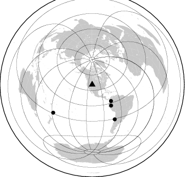
Nearby stations (2 deg radius)
| Station | Name | (Lat, Lon) | Start / End | Elevation |
| S208 | Eakin Pump Station | (41.42, -110.25) | 1997-08-31 / 1997-12-31 | 1982 m |
| Crust2 Type: | M2,extended crust, 2 km seds. |
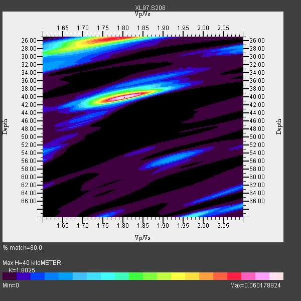
| Thickness Estimate: | 40 km |
| Thickness StdDev: | 10.0 km |
| Vp/Vs Estimate: | 1.80 |
| Vp/Vs StdDev: | 0.05 |
| Vs Estimate: | 3.415 km/s |
| Poisson's Ratio: | 0.28 |
| Peak Value: | 0.06 |
| Assumed Vp: | 6.155 km/s |
| Ps Weight: | 0.33333334 |
| PpPs Weight: | 0.33333334 |
| PsPs Weight: | 0.33333328 |
| Residual Complexity: | 0.755 |
| Nearby stations H: | +- |
| (2.0 deg) Vp/Vs: | +- |
1 with match > 90% ( 9.090909 %) and 4 with match > 80% ( 36.363636 %) out of 11.
Download stack as xyz text file.
Azimuth Distribution of Events:
Prior Results for this Station
| Study | Thickness | Vp/Vs | Vp | Vs | Poissons Ratio | Extra |
| EARS | 40 km | 1.80 | 6.155 km/s | 3.415 km/s | 0.28 | |
| Crust2.0 | 31 km | 1.78 | 6.155 km/s | 3.458 km/s | 0.27 | M2,extended crust, 2 km seds. |
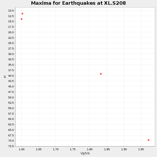
| Global Maxima | 40 km | 1.80 | 6.155 km/s | 3.415 km/s | 0.28 | amp=0.060178924 |
| Local Maxima 1 | 25 km | 1.79 | 6.155 km/s | 3.448 km/s | 0.27 | amp=0.051296514 |
| Local Maxima 2 | 28 km | 1.65 | 6.155 km/s | 3.725 km/s | 0.21 | amp=0.025330536 |
| Local Maxima 3 | 70 km | 1.97 | 6.155 km/s | 3.128 km/s | 0.33 | amp=0.023000048 |
| Local Maxima 4 | 39 km | 1.77 | 6.155 km/s | 3.468 km/s | 0.27 | amp=0.016435482 |
| Predicted Arrivals for vertical incidence (zero ray parameter) | |
| Ps | 5.22 SECOND |
| PpPs | 18.21 SECOND |
| PsPs/PpSs | 23.43 SECOND |
Events Processed for this Station
Download zip of receiver functions as SAC
Plot maxima for each earthquake.
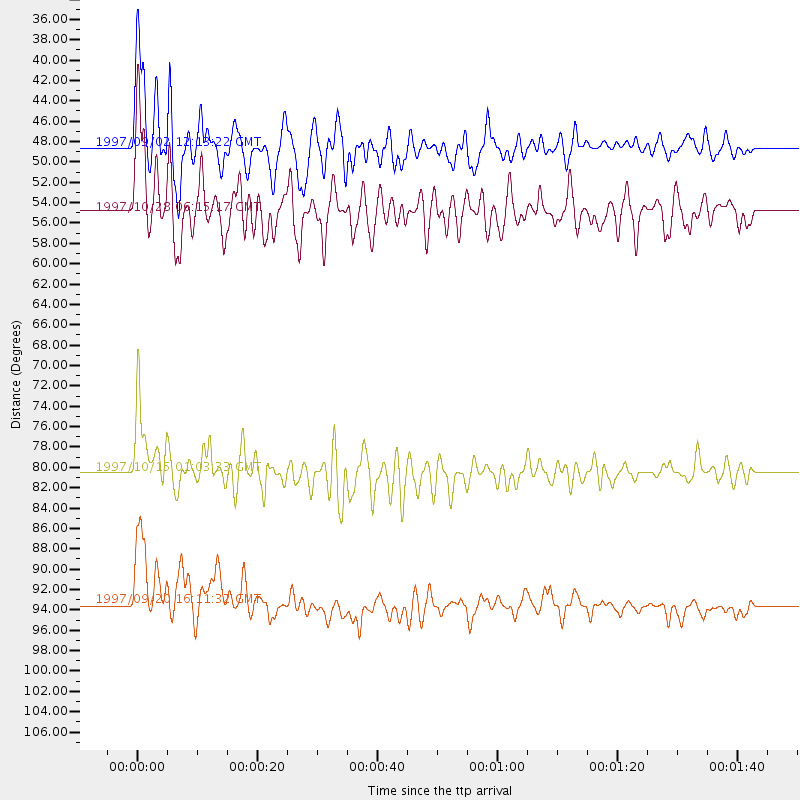
Events Used in the Stack
(4 events)| Radial Match | Distance | Baz | FERegion | Time | Lat/Lon | Depth | Magnitude |
| 90.76892 | 54.9 deg | 137.632 deg | Northern Peru | 1997/10/28 06:15:17 GMT | (-4.4, -76.7) | 112 km | 6.6 MB, 6.3 MS, 7.2 UNKNOWN, 6.6 ME |
| 89.99693 | 48.5 deg | 131.03 deg | Colombia | 1997/09/02 12:13:22 GMT | (3.8, -75.7) | 199 km | 6.5 MB, 6.8 UNKNOWN, 6.4 ME |
| 85.813446 | 93.5 deg | 234.341 deg | Kermadec Islands Region | 1997/09/20 16:11:32 GMT | (-28.7, -177.6) | 30 km | 6.1 MB, 7.0 MS, 7.2 UNKNOWN, 6.7 ME |
| 84.11221 | 80.5 deg | 146.727 deg | Near Coast Of Central Chile | 1997/10/15 01:03:33 GMT | (-30.9, -71.2) | 58 km | 6.8 MB, 6.8 MS, 7.3 UNKNOWN, 7.1 MW |
Losers
(7 events)| Radial Match | Distance | Baz | FERegion | Time | Lat/Lon | Depth | Magnitude | Reason |
| 74.363976 | 86.1 deg | 237.217 deg | Tonga Islands | 1997/09/10 12:57:07 GMT | (-21.3, -174.4) | 10 km | 5.7 MB, 6.1 MS, 6.1 UNKNOWN, 5.9 MW | |
| 72.822975 | 94.5 deg | 238.377 deg | South Of Fiji Islands | 1997/09/04 04:23:37 GMT | (-26.6, 178.3) | 625 km | 6.3 MB, 6.8 UNKNOWN, 6.5 ME | |
| 57.828583 | 74.4 deg | 140.176 deg | Northern Chile | 1997/09/28 23:13:13 GMT | (-22.4, -68.4) | 107 km | 5.7 MB, 5.6 UNKNOWN, 5.6 MW | |
| 55.92287 | 89.0 deg | 240.693 deg | Fiji Islands Region | 1997/11/04 10:40:43 GMT | (-21.0, -179.2) | 621 km | 5.7 UNKNOWN, 5.1 MB | |
| 49.32407 | 77.1 deg | 311.295 deg | Eastern Honshu, Japan | 1997/10/26 19:06:44 GMT | (39.3, 140.5) | 134 km | 5.6 UNKNOWN, 5.2 MB | |
| 34.379765 | 88.7 deg | 240.548 deg | Fiji Islands Region | 1997/10/17 15:02:00 GMT | (-20.9, -178.8) | 579 km | 5.3 MB, 6.0 UNKNOWN, 6.0 MW | |
| 27.074877 | 70.3 deg | 312.601 deg | Kuril Islands | 1997/10/22 09:55:47 GMT | (44.7, 146.2) | 154 km | 5.5 MB, 5.6 UNKNOWN, 5.6 MW |
