
Station XL S220 - Dinosaur NM
Network: XL97 - Deep Probe (Archean-Proterozoic)
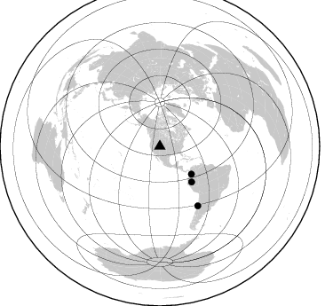
Nearby stations (2 deg radius)
| Station | Name | (Lat, Lon) | Start / End | Elevation |
| S220 | Dinosaur NM | (40.51, -109.21) | 1997-08-22 / 1997-12-31 | 1585 m |
| Crust2 Type: | Q4,orogen/43km no ice, Tethian Belt, 5 km seds. |
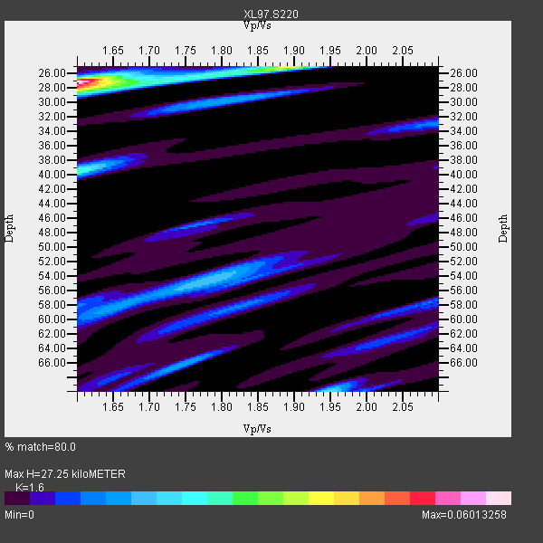
| Thickness Estimate: | 27 km |
| Thickness StdDev: | 14 km |
| Vp/Vs Estimate: | 1.60 |
| Vp/Vs StdDev: | 0.13 |
| Vs Estimate: | 3.879 km/s |
| Poisson's Ratio: | 0.18 |
| Peak Value: | 0.06 |
| Assumed Vp: | 6.207 km/s |
| Ps Weight: | 0.33333334 |
| PpPs Weight: | 0.33333334 |
| PsPs Weight: | 0.33333328 |
| Residual Complexity: | 0.636 |
| Nearby stations H: | +- |
| (2.0 deg) Vp/Vs: | +- |
2 with match > 90% ( 18.181818 %) and 3 with match > 80% ( 27.272728 %) out of 11.
Download stack as xyz text file.
Azimuth Distribution of Events:
Prior Results for this Station
| Study | Thickness | Vp/Vs | Vp | Vs | Poissons Ratio | Extra |
| EARS | 27 km | 1.60 | 6.207 km/s | 3.879 km/s | 0.18 | |
| Crust2.0 | 43 km | 1.76 | 6.207 km/s | 3.535 km/s | 0.26 | Q4,orogen/43km no ice, Tethian Belt, 5 km seds. |
| Global Maxima | 27 km | 1.60 | 6.207 km/s | 3.879 km/s | 0.18 | amp=0.06013258 |
| Local Maxima 1 | 40 km | 1.60 | 6.207 km/s | 3.879 km/s | 0.18 | amp=0.025492487 |
| Local Maxima 2 | 25 km | 1.89 | 6.207 km/s | 3.284 km/s | 0.31 | amp=0.022894535 |
| Local Maxima 3 | 70 km | 1.95 | 6.207 km/s | 3.187 km/s | 0.32 | amp=0.018822502 |
| Local Maxima 4 | 54 km | 1.78 | 6.207 km/s | 3.487 km/s | 0.27 | amp=0.017994793 |
| Predicted Arrivals for vertical incidence (zero ray parameter) | |
| Ps | 2.63 SECOND |
| PpPs | 11.41 SECOND |
| PsPs/PpSs | 14.05 SECOND |
Events Processed for this Station
Download zip of receiver functions as SAC
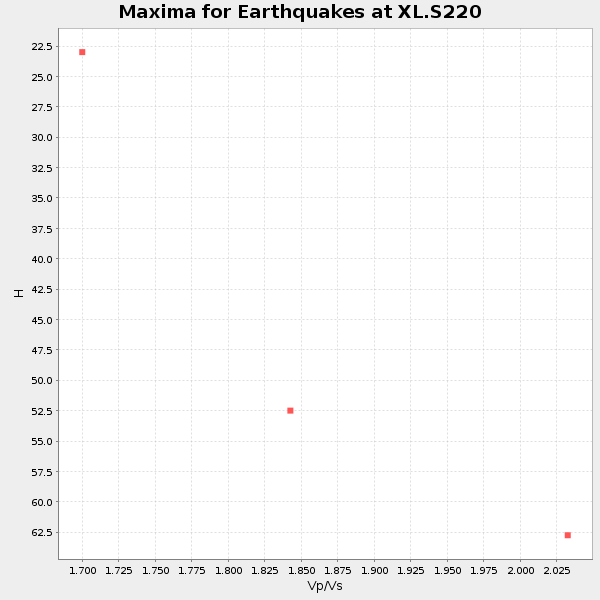
Plot maxima for each earthquake.
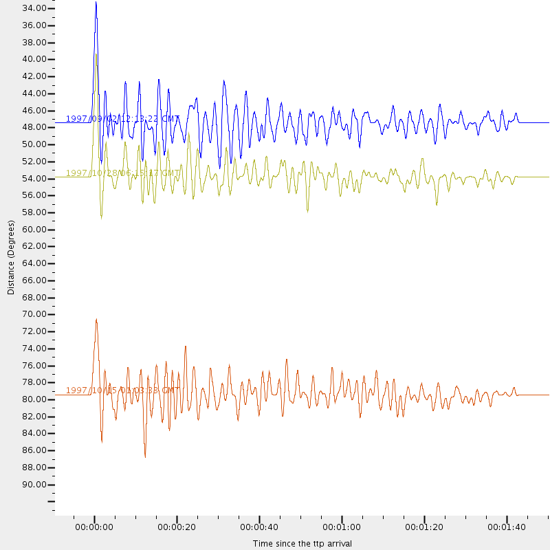
Events Used in the Stack
(3 events)| Radial Match | Distance | Baz | FERegion | Time | Lat/Lon | Depth | Magnitude |
| 92.62294 | 53.7 deg | 138.292 deg | Northern Peru | 1997/10/28 06:15:17 GMT | (-4.4, -76.7) | 112 km | 6.6 MB, 6.3 MS, 7.2 UNKNOWN, 6.6 ME |
| 90.995735 | 79.3 deg | 147.435 deg | Near Coast Of Central Chile | 1997/10/15 01:03:33 GMT | (-30.9, -71.2) | 58 km | 6.8 MB, 6.8 MS, 7.3 UNKNOWN, 7.1 MW |
| 86.70147 | 47.3 deg | 131.56 deg | Colombia | 1997/09/02 12:13:22 GMT | (3.8, -75.7) | 199 km | 6.5 MB, 6.8 UNKNOWN, 6.4 ME |
Losers
(8 events)| Radial Match | Distance | Baz | FERegion | Time | Lat/Lon | Depth | Magnitude | Reason |
| 73.43049 | 86.3 deg | 237.975 deg | Tonga Islands | 1997/09/10 12:57:07 GMT | (-21.3, -174.4) | 10 km | 5.7 MB, 6.1 MS, 6.1 UNKNOWN, 5.9 MW | |
| 71.377235 | 93.6 deg | 234.946 deg | Kermadec Islands Region | 1997/09/20 16:11:32 GMT | (-28.7, -177.6) | 30 km | 6.1 MB, 7.0 MS, 7.2 UNKNOWN, 6.7 ME | |
| 71.09764 | 94.7 deg | 238.96 deg | South Of Fiji Islands | 1997/09/04 04:23:37 GMT | (-26.6, 178.3) | 625 km | 6.3 MB, 6.8 UNKNOWN, 6.5 ME | |
| 58.00409 | 88.2 deg | 240.617 deg | Fiji Islands Region | 1997/08/25 11:59:00 GMT | (-20.8, -177.8) | 394 km | 5.5 UNKNOWN, 5.3 MB | |
| 53.693127 | 94.0 deg | 239.733 deg | South Of Fiji Islands | 1997/08/26 15:22:09 GMT | (-25.5, 178.3) | 610 km | 5.5 MB, 5.7 UNKNOWN | |
| 53.475285 | 88.9 deg | 241.252 deg | Fiji Islands Region | 1997/10/17 15:02:00 GMT | (-20.9, -178.8) | 579 km | 5.3 MB, 6.0 UNKNOWN, 6.0 MW | |
| 51.57068 | 96.8 deg | 191.269 deg | Pacific-Antarctic Ridge | 1997/09/03 06:22:44 GMT | (-55.2, -129.0) | 10 km | 5.1 MB, 6.0 MS, 6.1 UNKNOWN, 6.0 MW | |
| 45.209442 | 87.0 deg | 238.087 deg | Tonga Islands | 1997/10/19 15:53:38 GMT | (-21.8, -175.0) | 33 km | 5.6 MB, 5.9 MS |
