
Station XL S224 - Twin Wash
Network: XL97 - Deep Probe (Archean-Proterozoic)
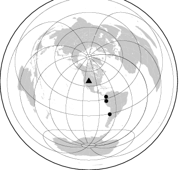
Nearby stations (2 deg radius)
| Station | Name | (Lat, Lon) | Start / End | Elevation |
| S224 | Twin Wash | (40.22, -108.98) | 1997-08-19 / 1997-12-31 | 1819 m |
| Crust2 Type: | Q4,orogen/43km no ice, Tethian Belt, 5 km seds. |
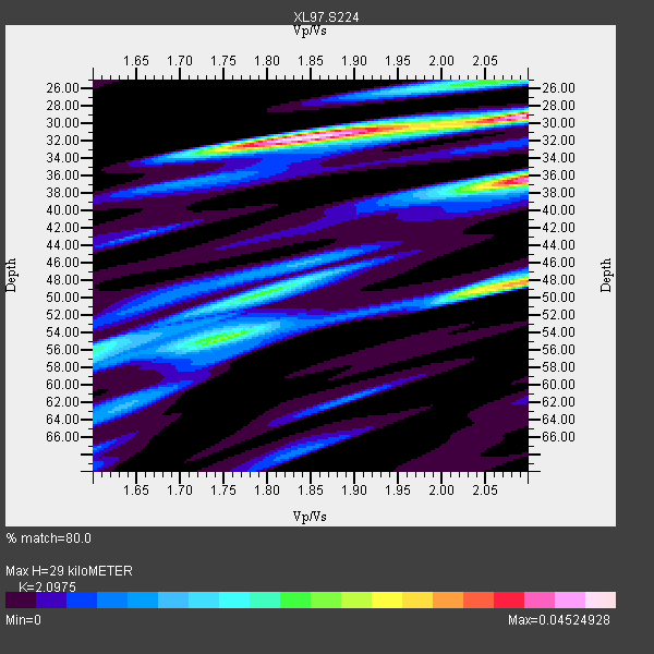
| Thickness Estimate: | 29 km |
| Thickness StdDev: | 10 km |
| Vp/Vs Estimate: | 2.10 |
| Vp/Vs StdDev: | 0.17 |
| Vs Estimate: | 2.959 km/s |
| Poisson's Ratio: | 0.35 |
| Peak Value: | 0.05 |
| Assumed Vp: | 6.207 km/s |
| Ps Weight: | 0.33333334 |
| PpPs Weight: | 0.33333334 |
| PsPs Weight: | 0.33333328 |
| Residual Complexity: | 0.805 |
| Nearby stations H: | +- |
| (2.0 deg) Vp/Vs: | +- |
2 with match > 90% ( 20.0 %) and 3 with match > 80% ( 30.0 %) out of 10.
Download stack as xyz text file.
Azimuth Distribution of Events:
Prior Results for this Station
| Study | Thickness | Vp/Vs | Vp | Vs | Poissons Ratio | Extra |
| EARS | 29 km | 2.10 | 6.207 km/s | 2.959 km/s | 0.35 | |
| Crust2.0 | 43 km | 1.76 | 6.207 km/s | 3.535 km/s | 0.26 | Q4,orogen/43km no ice, Tethian Belt, 5 km seds. |
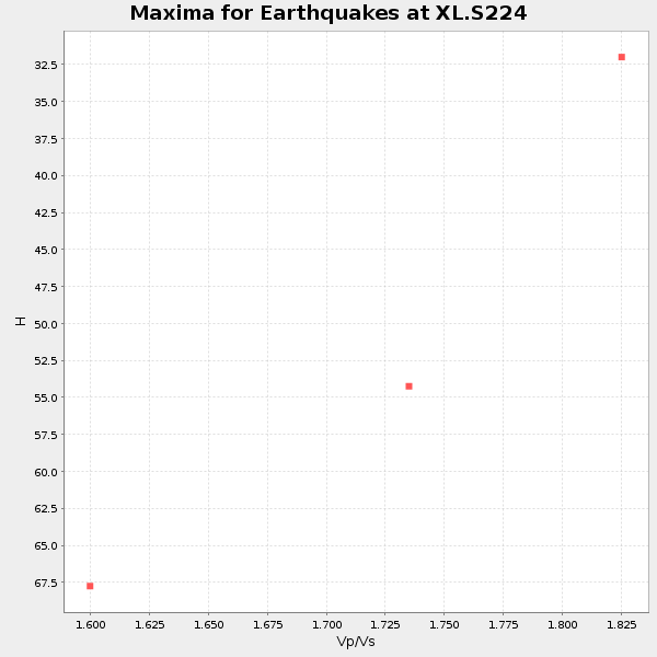
| Global Maxima | 29 km | 2.10 | 6.207 km/s | 2.959 km/s | 0.35 | amp=0.04524928 |
| Local Maxima 1 | 36 km | 2.10 | 6.207 km/s | 2.959 km/s | 0.35 | amp=0.042229712 |
| Local Maxima 2 | 32 km | 1.83 | 6.207 km/s | 3.392 km/s | 0.29 | amp=0.03452089 |
| Local Maxima 3 | 48 km | 2.10 | 6.207 km/s | 2.959 km/s | 0.35 | amp=0.03439184 |
| Local Maxima 4 | 50 km | 1.80 | 6.207 km/s | 3.458 km/s | 0.27 | amp=0.019146727 |
| Predicted Arrivals for vertical incidence (zero ray parameter) | |
| Ps | 5.13 SECOND |
| PpPs | 14.47 SECOND |
| PsPs/PpSs | 19.60 SECOND |
Events Processed for this Station
Download zip of receiver functions as SAC
Plot maxima for each earthquake.
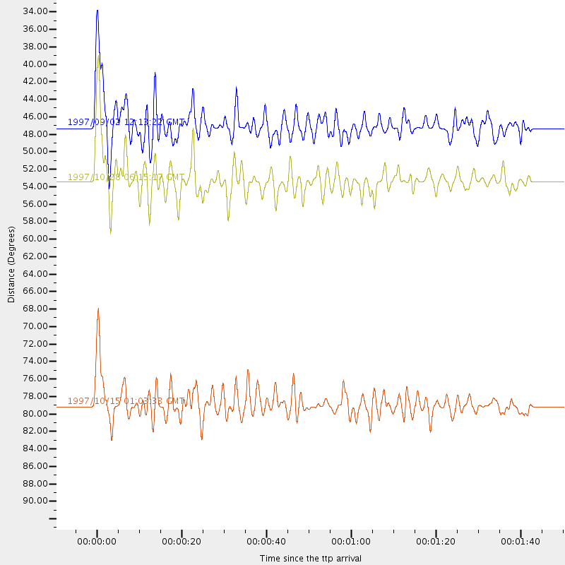
Events Used in the Stack
(3 events)| Radial Match | Distance | Baz | FERegion | Time | Lat/Lon | Depth | Magnitude |
| 94.26766 | 79.0 deg | 147.582 deg | Near Coast Of Central Chile | 1997/10/15 01:03:33 GMT | (-30.9, -71.2) | 58 km | 6.8 MB, 6.8 MS, 7.3 UNKNOWN, 7.1 MW |
| 93.61211 | 53.4 deg | 138.393 deg | Northern Peru | 1997/10/28 06:15:17 GMT | (-4.4, -76.7) | 112 km | 6.6 MB, 6.3 MS, 7.2 UNKNOWN, 6.6 ME |
| 80.613785 | 47.0 deg | 131.613 deg | Colombia | 1997/09/02 12:13:22 GMT | (3.8, -75.7) | 199 km | 6.5 MB, 6.8 UNKNOWN, 6.4 ME |
Losers
(7 events)| Radial Match | Distance | Baz | FERegion | Time | Lat/Lon | Depth | Magnitude | Reason |
| 80.323044 | 93.9 deg | 256.254 deg | Vanuatu Islands | 1997/10/31 12:29:49 GMT | (-13.1, 166.9) | 183 km | 5.9 UNKNOWN, 5.4 MB | |
| 77.13404 | 86.3 deg | 238.145 deg | Tonga Islands | 1997/09/10 12:57:07 GMT | (-21.3, -174.4) | 10 km | 5.7 MB, 6.1 MS, 6.1 UNKNOWN, 5.9 MW | |
| 76.12867 | 93.6 deg | 235.073 deg | Kermadec Islands Region | 1997/09/20 16:11:32 GMT | (-28.7, -177.6) | 30 km | 6.1 MB, 7.0 MS, 7.2 UNKNOWN, 6.7 ME | |
| 70.180336 | 94.7 deg | 239.08 deg | South Of Fiji Islands | 1997/09/04 04:23:37 GMT | (-26.6, 178.3) | 625 km | 6.3 MB, 6.8 UNKNOWN, 6.5 ME | |
| 45.941788 | 88.2 deg | 240.776 deg | Fiji Islands Region | 1997/08/25 11:59:00 GMT | (-20.8, -177.8) | 394 km | 5.5 UNKNOWN, 5.3 MB | |
| 39.42471 | 88.9 deg | 241.407 deg | Fiji Islands Region | 1997/10/17 15:02:00 GMT | (-20.9, -178.8) | 579 km | 5.3 MB, 6.0 UNKNOWN, 6.0 MW | |
| 26.101776 | 78.6 deg | 312.177 deg | Eastern Honshu, Japan | 1997/10/26 19:06:44 GMT | (39.3, 140.5) | 134 km | 5.6 UNKNOWN, 5.2 MB |
