
Station XN CVCR - XN.CVCR
Network: XN00 - RPI-UW Parkfield Calibration Array
Nearby stations (2 deg radius)
| Station | Name | (Lat, Lon) | Start / End | Elevation |
| CVCR | XN.CVCR | (35.99, -120.53) | 2001-06-24 / 2002-10-15 | 830 m |
| Crust2 Type: | S1,continental slope, margin, transition 1 km seds. |
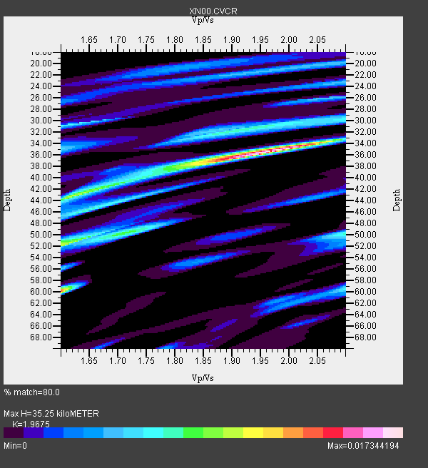
| Thickness Estimate: | 35 km |
| Thickness StdDev: | 11 km |
| Vp/Vs Estimate: | 1.97 |
| Vp/Vs StdDev: | 0.14 |
| Vs Estimate: | 3.142 km/s |
| Poisson's Ratio: | 0.33 |
| Peak Value: | 0.02 |
| Assumed Vp: | 6.183 km/s |
| Ps Weight: | 0.33333334 |
| PpPs Weight: | 0.33333334 |
| PsPs Weight: | 0.33333328 |
| Residual Complexity: | 0.748 |
| Nearby stations H: | 30 km +- 4.7 km |
| (2.0 deg) Vp/Vs: | 1.80 +- 0.16 |
1 with match > 90% ( 20.0 %) and 3 with match > 80% ( 60.0 %) out of 5.
Download stack as xyz text file.
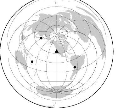
Azimuth Distribution of Events:
Prior Results for this Station
| Study | Thickness | Vp/Vs | Vp | Vs | Poissons Ratio | Extra |
| EARS | 35 km | 1.97 | 6.183 km/s | 3.142 km/s | 0.33 | |
| Crust2.0 | 23 km | 1.81 | 6.183 km/s | 3.422 km/s | 0.28 | S1,continental slope, margin, transition 1 km seds. |
| Global Maxima | 35 km | 1.97 | 6.183 km/s | 3.142 km/s | 0.33 | amp=0.017344194 |
| Local Maxima 1 | 60 km | 1.60 | 6.183 km/s | 3.864 km/s | 0.18 | amp=0.012568267 |
| Local Maxima 2 | 43 km | 1.62 | 6.183 km/s | 3.828 km/s | 0.19 | amp=0.009528212 |
| Local Maxima 3 | 52 km | 1.61 | 6.183 km/s | 3.84 km/s | 0.19 | amp=0.009508368 |
| Local Maxima 4 | 32 km | 1.91 | 6.183 km/s | 3.233 km/s | 0.31 | amp=0.007357414 |
| Predicted Arrivals for vertical incidence (zero ray parameter) | |
| Ps | 5.52 SECOND |
| PpPs | 16.92 SECOND |
| PsPs/PpSs | 22.44 SECOND |
Events Processed for this Station
Download zip of receiver functions as SAC
Plot maxima for each earthquake.
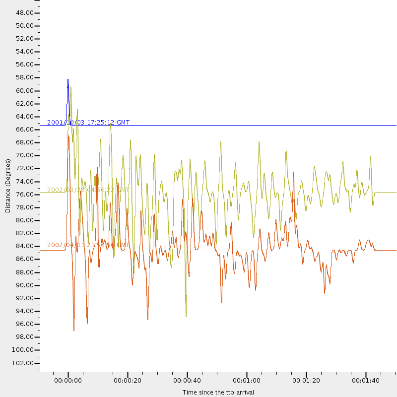
Events Used in the Stack
(3 events)| Radial Match | Distance | Baz | FERegion | Time | Lat/Lon | Depth | Magnitude |
| 100.0 | 65.2 deg | 311.182 deg | Northwest Of Kuril Islands | 2001/10/03 17:25:12 GMT | (47.1, 148.6) | 284 km | 5.6 MB, 5.9 MW, 5.9 MW |
| 89.27469 | 84.2 deg | 247.699 deg | Vanuatu Islands | 2002/04/11 21:56:56 GMT | (-14.4, 167.7) | 10 km | 5.9 MB, 6.2 MS, 6.2 MW, 6.1 MW |
| 86.85644 | 75.7 deg | 130.656 deg | Chile-Bolivia Border Region | 2002/03/28 04:56:22 GMT | (-21.7, -68.3) | 125 km | 6.1 MB, 6.5 MW, 6.5 MW |
Losers
(2 events)| Radial Match | Distance | Baz | FERegion | Time | Lat/Lon | Depth | Magnitude | Reason |
| 71.780594 | 82.0 deg | 134.471 deg | Catamarca Province, Argentina | 2002/05/28 04:04:22 GMT | (-28.9, -66.8) | 22 km | 6.0 MB, 5.7 MS, 6.0 MW, 5.9 MW | |
| 63.497677 | 76.8 deg | 236.228 deg | Fiji Islands Region | 2002/05/04 07:00:48 GMT | (-17.9, -178.7) | 560 km | 5.3 MB, 5.8 MW, 5.7 MW |
