
Station XN GLEN - XN.GLEN
Network: XN00 - RPI-UW Parkfield Calibration Array
Nearby stations (2 deg radius)
| Station | Name | (Lat, Lon) | Start / End | Elevation |
| GLEN | XN.GLEN | (35.93, -120.56) | 2001-06-24 / 2002-10-15 | 798 m |
| Crust2 Type: | S1,continental slope, margin, transition 1 km seds. |
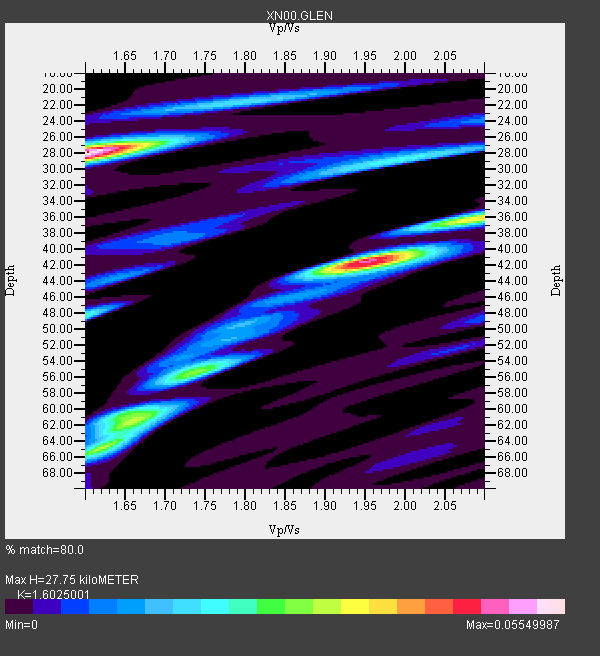
| Thickness Estimate: | 28 km |
| Thickness StdDev: | 11 km |
| Vp/Vs Estimate: | 1.60 |
| Vp/Vs StdDev: | 0.16 |
| Vs Estimate: | 3.858 km/s |
| Poisson's Ratio: | 0.18 |
| Peak Value: | 0.06 |
| Assumed Vp: | 6.183 km/s |
| Ps Weight: | 0.33333334 |
| PpPs Weight: | 0.33333334 |
| PsPs Weight: | 0.33333328 |
| Residual Complexity: | 0.869 |
| Nearby stations H: | +- |
| (2.0 deg) Vp/Vs: | +- |
4 with match > 90% ( 12.121212 %) and 19 with match > 80% ( 57.575756 %) out of 33.
Download stack as xyz text file.
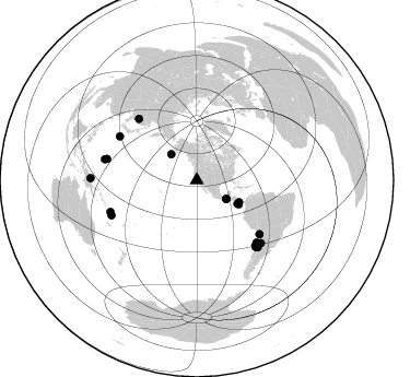
Azimuth Distribution of Events:
Prior Results for this Station
| Study | Thickness | Vp/Vs | Vp | Vs | Poissons Ratio | Extra |
| EARS | 28 km | 1.60 | 6.183 km/s | 3.858 km/s | 0.18 | |
| Crust2.0 | 23 km | 1.81 | 6.183 km/s | 3.422 km/s | 0.28 | S1,continental slope, margin, transition 1 km seds. |
| Global Maxima | 28 km | 1.60 | 6.183 km/s | 3.858 km/s | 0.18 | amp=0.05549987 |
| Local Maxima 1 | 42 km | 1.95 | 6.183 km/s | 3.175 km/s | 0.32 | amp=0.04824524 |
| Local Maxima 2 | 62 km | 1.66 | 6.183 km/s | 3.724 km/s | 0.22 | amp=0.032450173 |
| Local Maxima 3 | 36 km | 2.10 | 6.183 km/s | 2.948 km/s | 0.35 | amp=0.026376437 |
| Local Maxima 4 | 55 km | 1.74 | 6.183 km/s | 3.553 km/s | 0.25 | amp=0.02393755 |
| Predicted Arrivals for vertical incidence (zero ray parameter) | |
| Ps | 2.70 SECOND |
| PpPs | 11.68 SECOND |
| PsPs/PpSs | 14.39 SECOND |
Events Processed for this Station
Download zip of receiver functions as SAC
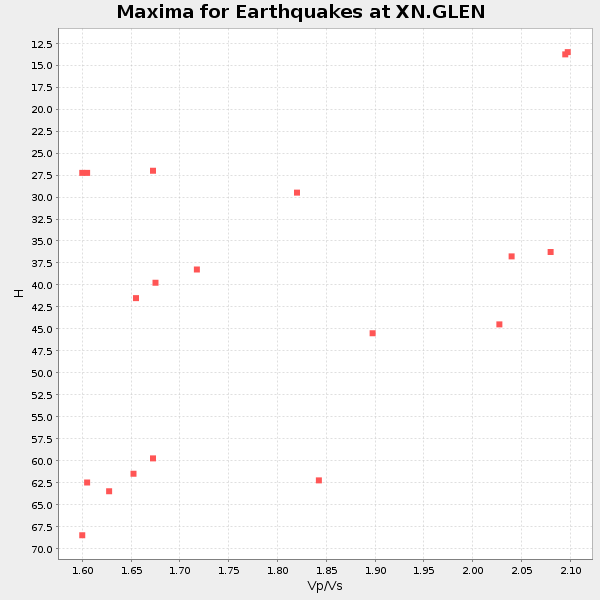
Plot maxima for each earthquake.
Events Used in the Stack
(19 events)| Radial Match | Distance | Baz | FERegion | Time | Lat/Lon | Depth | Magnitude |
| 91.7927 | 82.6 deg | 137.723 deg | San Juan Province, Argentina | 2002/09/24 03:57:22 GMT | (-31.5, -69.2) | 120 km | 6.2 MB, 6.4 MW, 6.3 MW |
| 91.269455 | 84.4 deg | 283.271 deg | Mariana Islands | 2002/08/14 13:57:52 GMT | (14.1, 146.2) | 30 km | 6.1 MB, 6.4 MS, 6.5 MW, 6.4 MW |
| 90.76244 | 81.0 deg | 138.561 deg | Near Coast Of Central Chile | 2002/06/18 13:56:22 GMT | (-30.8, -71.1) | 54 km | 6.0 MB, 6.6 MW, 6.4 MW |
| 90.665 | 31.8 deg | 122.631 deg | Near Coast Of Chiapas, Mexico | 2002/01/16 23:09:52 GMT | (15.5, -93.1) | 80 km | 5.8 MB, 6.4 MW, 6.4 MW |
| 89.920166 | 31.8 deg | 122.504 deg | Near Coast Of Chiapas, Mexico | 2001/11/28 14:32:32 GMT | (15.6, -93.1) | 85 km | 5.7 MB, 6.4 MW, 6.4 MW |
| 89.783356 | 44.3 deg | 119.713 deg | South Of Panama | 2002/07/31 00:16:44 GMT | (7.9, -82.8) | 10 km | 6.0 MB, 6.4 MS, 6.5 MW, 6.4 MW |
| 89.73457 | 75.6 deg | 130.618 deg | Chile-Bolivia Border Region | 2002/03/28 04:56:22 GMT | (-21.7, -68.3) | 125 km | 6.1 MB, 6.5 MW, 6.5 MW |
| 88.79636 | 80.0 deg | 138.023 deg | Near Coast Of Central Chile | 2002/04/01 19:59:32 GMT | (-29.7, -71.4) | 71 km | 6.1 MB, 6.4 MW, 6.4 MW |
| 88.263466 | 86.2 deg | 282.819 deg | South Of Mariana Islands | 2001/10/12 15:02:16 GMT | (12.7, 145.0) | 37 km | 6.7 MB, 7.3 MS, 7.0 MW, 6.9 MW |
| 87.47407 | 33.3 deg | 315.349 deg | South Of Alaska | 2002/05/25 05:36:31 GMT | (53.8, -161.1) | 33 km | 5.5 MB, 6.1 MS, 6.5 MW, 6.4 MW |
| 87.21512 | 77.4 deg | 316.596 deg | Northeastern China | 2002/09/15 08:39:32 GMT | (44.8, 129.9) | 586 km | 5.8 MB, 6.4 MW, 6.4 MW |
| 86.93773 | 42.9 deg | 120.047 deg | Costa Rica | 2002/06/16 02:46:14 GMT | (8.8, -84.0) | 35 km | 5.4 MB, 6.2 MS, 6.4 MW, 6.4 MW |
| 85.43672 | 82.0 deg | 134.441 deg | Catamarca Province, Argentina | 2002/05/28 04:04:22 GMT | (-28.9, -66.8) | 22 km | 6.0 MB, 5.7 MS, 6.0 MW, 5.9 MW |
| 85.195305 | 97.2 deg | 271.126 deg | Near N Coast Of New Guinea, P.N.G. | 2002/09/08 18:44:23 GMT | (-3.3, 142.9) | 13 km | 6.5 MB, 7.8 MS, 7.6 MW, 7.3 MW |
| 84.46893 | 84.1 deg | 247.682 deg | Vanuatu Islands | 2002/04/11 21:56:56 GMT | (-14.4, 167.7) | 10 km | 5.9 MB, 6.2 MS, 6.2 MW, 6.1 MW |
| 83.46649 | 78.8 deg | 136.108 deg | Near Coast Of Northern Chile | 2002/04/18 16:08:36 GMT | (-27.5, -70.6) | 62 km | 6.2 MB, 6.7 MW, 6.6 MW |
| 83.34396 | 84.0 deg | 249.883 deg | Santa Cruz Islands | 2002/06/17 21:26:22 GMT | (-12.6, 166.4) | 33 km | 6.0 MB, 6.7 MS, 6.7 MW, 6.6 MW |
| 81.53111 | 43.5 deg | 117.455 deg | Panama-Costa Rica Border Region | 2001/11/09 00:47:55 GMT | (9.6, -82.3) | 10 km | 6.1 MB, 5.7 MS, 6.1 MW, 6.1 MW |
| 80.458145 | 81.1 deg | 299.578 deg | Southeast Of Honshu, Japan | 2002/08/02 23:11:39 GMT | (29.3, 139.0) | 426 km | 5.5 MB, 6.3 MW, 6.3 MW |
Losers
(14 events)| Radial Match | Distance | Baz | FERegion | Time | Lat/Lon | Depth | Magnitude | Reason |
| 78.90333 | 76.7 deg | 236.21 deg | Fiji Islands Region | 2002/06/16 06:55:13 GMT | (-17.9, -178.7) | 569 km | 5.7 MB, 5.9 MW, 5.9 MW | |
| 76.52013 | 86.8 deg | 254.537 deg | Solomon Islands | 2002/09/24 23:01:28 GMT | (-10.6, 161.2) | 19 km | 5.7 MB, 6.5 MS, 6.3 MW, 6.3 MW | |
| 74.01377 | 79.9 deg | 234.014 deg | Fiji Islands Region | 2002/08/19 11:01:01 GMT | (-21.7, -179.5) | 580 km | 6.7 MB, 7.6 MW, 7.7 ME | |
| 73.064896 | 81.1 deg | 234.474 deg | South Of Fiji Islands | 2002/06/30 21:29:36 GMT | (-22.2, 179.2) | 620 km | 5.5 MB, 6.5 MW, 6.4 MW | |
| 69.510185 | 86.8 deg | 254.634 deg | Solomon Islands | 2002/09/24 04:13:11 GMT | (-10.5, 161.2) | 10 km | 5.5 MB, 6.2 MS, 6.0 MW, 5.9 MW | |
| 69.30875 | 72.8 deg | 236.204 deg | Tonga Islands | 2002/06/21 14:21:44 GMT | (-15.1, -175.9) | 319 km | 5.7 MB, 5.7 MW, 5.7 MW | |
| 68.901566 | 49.9 deg | 117.864 deg | Near West Coast Of Colombia | 2002/08/08 13:39:58 GMT | (5.0, -77.8) | 43 km | 5.4 MB, 5.0 MS, 5.9 MW, 5.7 MW | |
| 66.484474 | 86.4 deg | 242.925 deg | Vanuatu Islands | 2002/08/12 02:59:24 GMT | (-19.5, 169.0) | 112 km | 5.6 MB, 6.0 MW, 5.9 MW | |
| 62.95387 | 78.2 deg | 231.905 deg | Fiji Islands Region | 2002/08/07 04:50:06 GMT | (-21.9, -176.6) | 174 km | 5.4 MB, 5.8 MW, 5.7 MW | |
| 62.8671 | 83.9 deg | 248.94 deg | Vanuatu Islands | 2002/06/27 07:16:10 GMT | (-13.3, 167.1) | 187 km | 6.0 MB, 6.1 MW | |
| 61.38305 | 76.8 deg | 236.215 deg | Fiji Islands Region | 2002/05/04 07:00:48 GMT | (-17.9, -178.7) | 560 km | 5.3 MB, 5.8 MW, 5.7 MW | |
| 49.89171 | 80.0 deg | 233.829 deg | Fiji Islands Region | 2002/08/19 11:45:29 GMT | (-21.9, -179.4) | 600 km | 5.5 MB | |
| 48.8856 | 61.8 deg | 311.176 deg | Kuril Islands | 2002/07/17 02:20:33 GMT | (48.5, 153.3) | 148 km | 5.3 MB, 5.6 MW, 5.6 MW | |
| 47.962723 | 81.5 deg | 297.755 deg | Bonin Islands, Japan Region | 2002/06/03 09:15:00 GMT | (27.6, 139.8) | 489 km | 5.0 MB, 5.9 MW, 5.9 MW |
