
Station XN GOBI - XN.GOBI
Network: XN00 - RPI-UW Parkfield Calibration Array
Nearby stations (2 deg radius)
| Station | Name | (Lat, Lon) | Start / End | Elevation |
| GOBI | XN.GOBI | (35.94, -120.54) | 2001-06-24 / 2002-10-15 | 700 m |
| Crust2 Type: | S1,continental slope, margin, transition 1 km seds. |
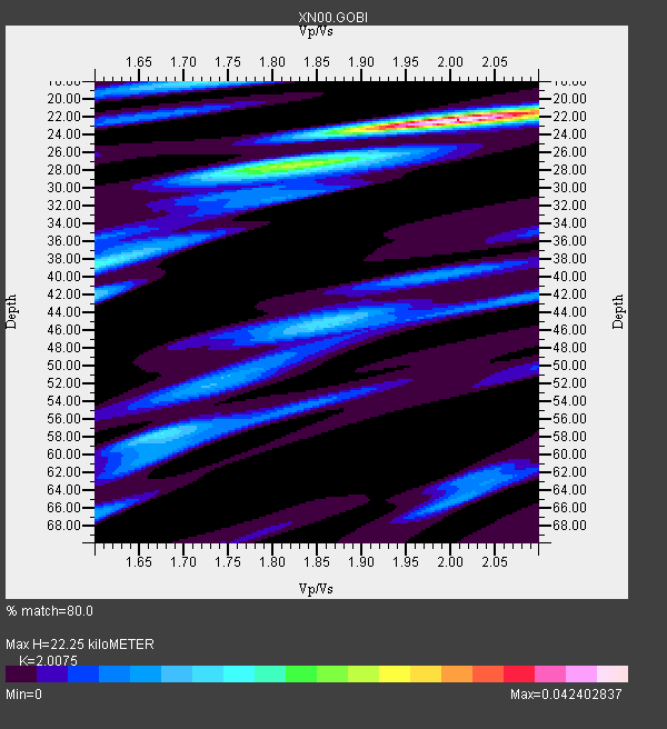
| Thickness Estimate: | 22 km |
| Thickness StdDev: | 4.2 km |
| Vp/Vs Estimate: | 2.01 |
| Vp/Vs StdDev: | 0.08 |
| Vs Estimate: | 3.08 km/s |
| Poisson's Ratio: | 0.33 |
| Peak Value: | 0.04 |
| Assumed Vp: | 6.183 km/s |
| Ps Weight: | 0.33333334 |
| PpPs Weight: | 0.33333334 |
| PsPs Weight: | 0.33333328 |
| Residual Complexity: | 0.628 |
| Nearby stations H: | 26 km +- 2.6 km |
| (2.0 deg) Vp/Vs: | 1.87 +- 0.11 |
2 with match > 90% ( 7.6923075 %) and 12 with match > 80% ( 46.153847 %) out of 26.
Download stack as xyz text file.
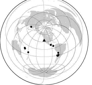
Azimuth Distribution of Events:
Prior Results for this Station
| Study | Thickness | Vp/Vs | Vp | Vs | Poissons Ratio | Extra |
| EARS | 22 km | 2.01 | 6.183 km/s | 3.08 km/s | 0.33 | |
| Crust2.0 | 23 km | 1.81 | 6.183 km/s | 3.422 km/s | 0.28 | S1,continental slope, margin, transition 1 km seds. |
| Global Maxima | 22 km | 2.01 | 6.183 km/s | 3.08 km/s | 0.33 | amp=0.042402837 |
| Local Maxima 1 | 28 km | 1.78 | 6.183 km/s | 3.473 km/s | 0.27 | amp=0.01628205 |
| Local Maxima 2 | 18 km | 1.72 | 6.183 km/s | 3.6 km/s | 0.24 | amp=0.01508735 |
| Local Maxima 3 | 58 km | 1.68 | 6.183 km/s | 3.691 km/s | 0.22 | amp=0.014877056 |
| Local Maxima 4 | 38 km | 1.60 | 6.183 km/s | 3.864 km/s | 0.18 | amp=0.013779727 |
| Predicted Arrivals for vertical incidence (zero ray parameter) | |
| Ps | 3.63 SECOND |
| PpPs | 10.82 SECOND |
| PsPs/PpSs | 14.45 SECOND |
Events Processed for this Station
Download zip of receiver functions as SAC
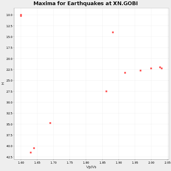
Plot maxima for each earthquake.
Events Used in the Stack
(12 events)| Radial Match | Distance | Baz | FERegion | Time | Lat/Lon | Depth | Magnitude |
| 92.10968 | 42.9 deg | 120.075 deg | Costa Rica | 2002/06/16 02:46:14 GMT | (8.8, -84.0) | 35 km | 5.4 MB, 6.2 MS, 6.4 MW, 6.4 MW |
| 91.17871 | 31.8 deg | 122.541 deg | Near Coast Of Chiapas, Mexico | 2001/11/28 14:32:32 GMT | (15.6, -93.1) | 85 km | 5.7 MB, 6.4 MW, 6.4 MW |
| 88.118065 | 31.8 deg | 122.668 deg | Near Coast Of Chiapas, Mexico | 2002/01/16 23:09:52 GMT | (15.5, -93.1) | 80 km | 5.8 MB, 6.4 MW, 6.4 MW |
| 87.72538 | 84.2 deg | 247.695 deg | Vanuatu Islands | 2002/04/11 21:56:56 GMT | (-14.4, 167.7) | 10 km | 5.9 MB, 6.2 MS, 6.2 MW, 6.1 MW |
| 87.03157 | 75.6 deg | 130.635 deg | Chile-Bolivia Border Region | 2002/03/28 04:56:22 GMT | (-21.7, -68.3) | 125 km | 6.1 MB, 6.5 MW, 6.5 MW |
| 85.149284 | 82.6 deg | 137.738 deg | San Juan Province, Argentina | 2002/09/24 03:57:22 GMT | (-31.5, -69.2) | 120 km | 6.2 MB, 6.4 MW, 6.3 MW |
| 85.027084 | 81.0 deg | 138.576 deg | Near Coast Of Central Chile | 2002/06/18 13:56:22 GMT | (-30.8, -71.1) | 54 km | 6.0 MB, 6.6 MW, 6.4 MW |
| 84.97747 | 80.0 deg | 234.028 deg | Fiji Islands Region | 2002/08/19 11:01:01 GMT | (-21.7, -179.5) | 580 km | 6.7 MB, 7.6 MW, 7.7 ME |
| 84.27368 | 77.4 deg | 316.605 deg | Northeastern China | 2002/09/15 08:39:32 GMT | (44.8, 129.9) | 586 km | 5.8 MB, 6.4 MW, 6.4 MW |
| 83.81944 | 84.0 deg | 249.896 deg | Santa Cruz Islands | 2002/06/17 21:26:22 GMT | (-12.6, 166.4) | 33 km | 6.0 MB, 6.7 MS, 6.7 MW, 6.6 MW |
| 81.9925 | 82.0 deg | 134.456 deg | Catamarca Province, Argentina | 2002/05/28 04:04:22 GMT | (-28.9, -66.8) | 22 km | 6.0 MB, 5.7 MS, 6.0 MW, 5.9 MW |
| 81.39279 | 80.0 deg | 138.039 deg | Near Coast Of Central Chile | 2002/04/01 19:59:32 GMT | (-29.7, -71.4) | 71 km | 6.1 MB, 6.4 MW, 6.4 MW |
Losers
(14 events)| Radial Match | Distance | Baz | FERegion | Time | Lat/Lon | Depth | Magnitude | Reason |
| 78.09914 | 86.8 deg | 254.549 deg | Solomon Islands | 2002/09/24 23:01:28 GMT | (-10.6, 161.2) | 19 km | 5.7 MB, 6.5 MS, 6.3 MW, 6.3 MW | |
| 75.788635 | 81.1 deg | 299.589 deg | Southeast Of Honshu, Japan | 2002/08/02 23:11:39 GMT | (29.3, 139.0) | 426 km | 5.5 MB, 6.3 MW, 6.3 MW | |
| 71.98109 | 80.9 deg | 138.591 deg | Near Coast Of Central Chile | 2002/05/23 15:52:15 GMT | (-30.7, -71.2) | 52 km | 5.7 MB, 6.0 MW, 6.0 MW | |
| 71.1577 | 85.0 deg | 246.918 deg | Vanuatu Islands | 2002/06/10 02:53:47 GMT | (-15.5, 167.5) | 116 km | 5.6 MW, 5.2 MB, 5.6 MW | |
| 71.11566 | 82.6 deg | 233.968 deg | South Of Fiji Islands | 2002/08/19 11:03:13 GMT | (-23.6, 178.5) | 650 km | 5.9 MB | |
| 70.36317 | 81.1 deg | 234.487 deg | South Of Fiji Islands | 2002/06/30 21:29:36 GMT | (-22.2, 179.2) | 620 km | 5.5 MB, 6.5 MW, 6.4 MW | |
| 66.31683 | 86.4 deg | 242.938 deg | Vanuatu Islands | 2002/08/12 02:59:24 GMT | (-19.5, 169.0) | 112 km | 5.6 MB, 6.0 MW, 5.9 MW | |
| 65.85805 | 76.7 deg | 236.224 deg | Fiji Islands Region | 2002/06/16 06:55:13 GMT | (-17.9, -178.7) | 569 km | 5.7 MB, 5.9 MW, 5.9 MW | |
| 62.498676 | 76.8 deg | 236.229 deg | Fiji Islands Region | 2002/05/04 07:00:48 GMT | (-17.9, -178.7) | 560 km | 5.3 MB, 5.8 MW, 5.7 MW | |
| 61.03712 | 83.9 deg | 248.953 deg | Vanuatu Islands | 2002/06/27 07:16:10 GMT | (-13.3, 167.1) | 187 km | 6.0 MB, 6.1 MW | |
| 59.411835 | 78.2 deg | 231.919 deg | Fiji Islands Region | 2002/08/07 04:50:06 GMT | (-21.9, -176.6) | 174 km | 5.4 MB, 5.8 MW, 5.7 MW | |
| 59.116722 | 88.7 deg | 259.002 deg | Solomon Islands | 2002/07/14 16:35:14 GMT | (-8.2, 157.0) | 18 km | 5.5 MB, 5.6 MS, 5.8 MW, 5.7 MW | |
| 55.599064 | 72.9 deg | 236.218 deg | Tonga Islands | 2002/06/21 14:21:44 GMT | (-15.1, -175.9) | 319 km | 5.7 MB, 5.7 MW, 5.7 MW | |
| 47.76727 | 80.1 deg | 233.842 deg | Fiji Islands Region | 2002/08/19 11:45:29 GMT | (-21.9, -179.4) | 600 km | 5.5 MB |
