
Station XN JETS - XN.JETS
Network: XN00 - RPI-UW Parkfield Calibration Array
Nearby stations (2 deg radius)
| Station | Name | (Lat, Lon) | Start / End | Elevation |
| JETS | XN.JETS | (35.96, -120.51) | 2001-06-24 / 2002-10-15 | 859 m |
| Crust2 Type: | S1,continental slope, margin, transition 1 km seds. |
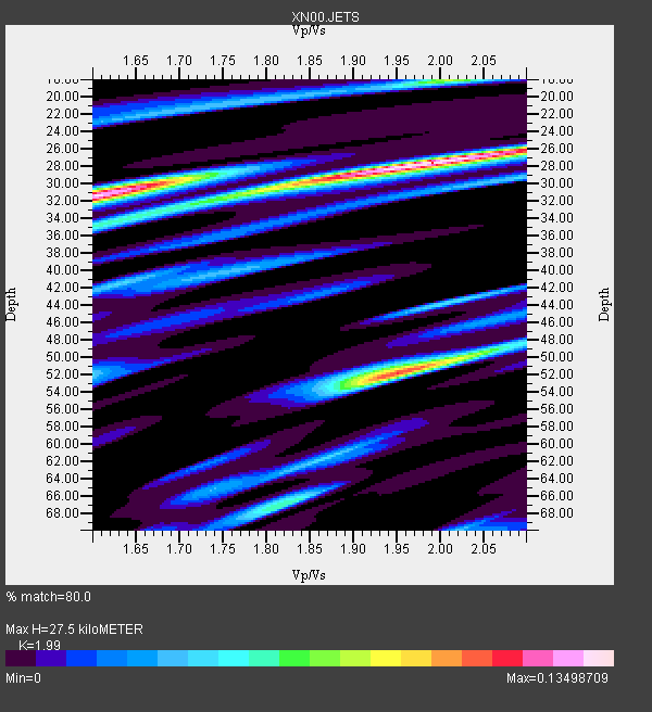
| Thickness Estimate: | 28 km |
| Thickness StdDev: | 11 km |
| Vp/Vs Estimate: | 1.99 |
| Vp/Vs StdDev: | 0.04 |
| Vs Estimate: | 3.107 km/s |
| Poisson's Ratio: | 0.33 |
| Peak Value: | 0.13 |
| Assumed Vp: | 6.183 km/s |
| Ps Weight: | 0.33333334 |
| PpPs Weight: | 0.33333334 |
| PsPs Weight: | 0.33333328 |
| Residual Complexity: | 0.745 |
| Nearby stations H: | 29 km +- 1.2 km |
| (2.0 deg) Vp/Vs: | 1.91 +- 0.23 |
1 with match > 90% ( 50.0 %) and 2 with match > 80% ( 100.0 %) out of 2.
Download stack as xyz text file.
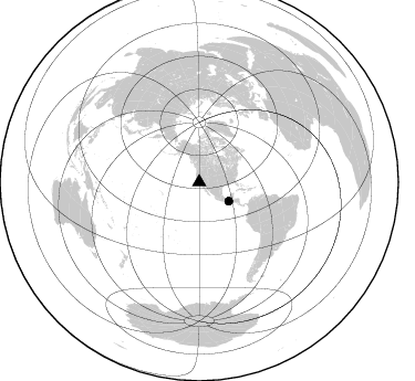
Azimuth Distribution of Events:
Prior Results for this Station
| Study | Thickness | Vp/Vs | Vp | Vs | Poissons Ratio | Extra |
| EARS | 28 km | 1.99 | 6.183 km/s | 3.107 km/s | 0.33 | |
| Crust2.0 | 23 km | 1.81 | 6.183 km/s | 3.422 km/s | 0.28 | S1,continental slope, margin, transition 1 km seds. |
| Global Maxima | 28 km | 1.99 | 6.183 km/s | 3.107 km/s | 0.33 | amp=0.13498709 |
| Local Maxima 1 | 52 km | 1.95 | 6.183 km/s | 3.171 km/s | 0.32 | amp=0.10809573 |
| Local Maxima 2 | 31 km | 1.63 | 6.183 km/s | 3.799 km/s | 0.20 | amp=0.09992385 |
| Local Maxima 3 | 18 km | 2.01 | 6.183 km/s | 3.08 km/s | 0.33 | amp=0.062513605 |
| Local Maxima 4 | 31 km | 1.79 | 6.183 km/s | 3.449 km/s | 0.27 | amp=0.06076853 |
| Predicted Arrivals for vertical incidence (zero ray parameter) | |
| Ps | 4.40 SECOND |
| PpPs | 13.30 SECOND |
| PsPs/PpSs | 17.70 SECOND |
Events Processed for this Station
Download zip of receiver functions as SAC
Plot maxima for each earthquake.
Events Used in the Stack
(2 events)| Radial Match | Distance | Baz | FERegion | Time | Lat/Lon | Depth | Magnitude |
| 90.75786 | 31.8 deg | 122.612 deg | Near Coast Of Chiapas, Mexico | 2001/11/28 14:32:32 GMT | (15.6, -93.1) | 85 km | 5.7 MB, 6.4 MW, 6.4 MW |
| 89.10626 | 31.8 deg | 122.74 deg | Near Coast Of Chiapas, Mexico | 2002/01/16 23:09:52 GMT | (15.5, -93.1) | 80 km | 5.8 MB, 6.4 MW, 6.4 MW |
Losers
(0 events)| Radial Match | Distance | Baz | FERegion | Time | Lat/Lon | Depth | Magnitude | Reason |
