
Station XN POLE - XN.POLE
Network: XN00 - RPI-UW Parkfield Calibration Array
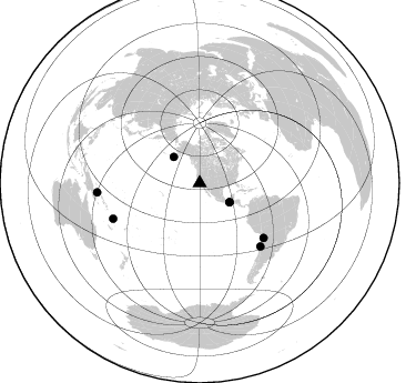
Nearby stations (2 deg radius)
| Station | Name | (Lat, Lon) | Start / End | Elevation |
| POLE | XN.POLE | (36.01, -120.57) | 2001-06-24 / 2002-10-15 | 596 m |
| Crust2 Type: | T4,Margin /shield transition, East Siberia, 2 km seds. |
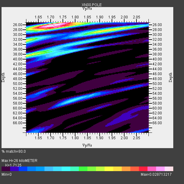
| Thickness Estimate: | 26 km |
| Thickness StdDev: | 7.0 km |
| Vp/Vs Estimate: | 1.71 |
| Vp/Vs StdDev: | 0.11 |
| Vs Estimate: | 3.732 km/s |
| Poisson's Ratio: | 0.24 |
| Peak Value: | 0.03 |
| Assumed Vp: | 6.391 km/s |
| Ps Weight: | 0.33333334 |
| PpPs Weight: | 0.33333334 |
| PsPs Weight: | 0.33333328 |
| Residual Complexity: | 0.715 |
| Nearby stations H: | 40 km +- 20 km |
| (2.0 deg) Vp/Vs: | 1.84 +- 0.23 |
1 with match > 90% ( 11.111111 %) and 7 with match > 80% ( 77.77778 %) out of 9.
Download stack as xyz text file.
Azimuth Distribution of Events:
Prior Results for this Station
| Study | Thickness | Vp/Vs | Vp | Vs | Poissons Ratio | Extra |
| EARS | 26 km | 1.71 | 6.391 km/s | 3.732 km/s | 0.24 | |
| Crust2.0 | 32 km | 1.79 | 6.391 km/s | 3.572 km/s | 0.27 | T4,Margin /shield transition, East Siberia, 2 km seds. |
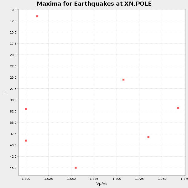
| Global Maxima | 26 km | 1.71 | 6.391 km/s | 3.732 km/s | 0.24 | amp=0.028713217 |
| Local Maxima 1 | 38 km | 1.62 | 6.391 km/s | 3.951 km/s | 0.19 | amp=0.020468963 |
| Local Maxima 2 | 28 km | 1.94 | 6.391 km/s | 3.29 km/s | 0.32 | amp=0.019642603 |
| Local Maxima 3 | 32 km | 1.60 | 6.391 km/s | 3.994 km/s | 0.18 | amp=0.01575889 |
| Local Maxima 4 | 27 km | 1.72 | 6.391 km/s | 3.71 km/s | 0.25 | amp=0.014027333 |
| Predicted Arrivals for vertical incidence (zero ray parameter) | |
| Ps | 2.90 SECOND |
| PpPs | 11.04 SECOND |
| PsPs/PpSs | 13.93 SECOND |
Events Processed for this Station
Download zip of receiver functions as SAC
Plot maxima for each earthquake.
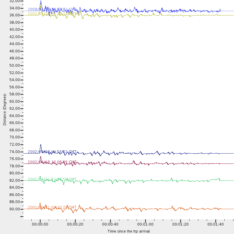
Events Used in the Stack
(7 events)| Radial Match | Distance | Baz | FERegion | Time | Lat/Lon | Depth | Magnitude |
| 92.33931 | 33.2 deg | 315.275 deg | South Of Alaska | 2002/05/25 05:36:31 GMT | (53.8, -161.1) | 33 km | 5.5 MB, 6.1 MS, 6.5 MW, 6.4 MW |
| 88.32353 | 31.8 deg | 122.589 deg | Near Coast Of Chiapas, Mexico | 2001/11/28 14:32:32 GMT | (15.6, -93.1) | 85 km | 5.7 MB, 6.4 MW, 6.4 MW |
| 87.55596 | 75.7 deg | 130.625 deg | Chile-Bolivia Border Region | 2002/03/28 04:56:22 GMT | (-21.7, -68.3) | 125 km | 6.1 MB, 6.5 MW, 6.5 MW |
| 87.349625 | 84.2 deg | 247.669 deg | Vanuatu Islands | 2002/04/11 21:56:56 GMT | (-14.4, 167.7) | 10 km | 5.9 MB, 6.2 MS, 6.2 MW, 6.1 MW |
| 85.81105 | 31.9 deg | 122.716 deg | Near Coast Of Chiapas, Mexico | 2002/01/16 23:09:52 GMT | (15.5, -93.1) | 80 km | 5.8 MB, 6.4 MW, 6.4 MW |
| 80.37836 | 92.8 deg | 264.785 deg | New Britain Region, P.N.G. | 2001/10/31 09:10:20 GMT | (-5.9, 150.2) | 33 km | 5.9 MB, 6.9 MS, 6.9 MW, 6.9 MW |
| 80.30465 | 78.8 deg | 136.11 deg | Near Coast Of Northern Chile | 2002/04/18 16:08:36 GMT | (-27.5, -70.6) | 62 km | 6.2 MB, 6.7 MW, 6.6 MW |
Losers
(2 events)| Radial Match | Distance | Baz | FERegion | Time | Lat/Lon | Depth | Magnitude | Reason |
| 79.57673 | 82.1 deg | 134.441 deg | Catamarca Province, Argentina | 2002/05/28 04:04:22 GMT | (-28.9, -66.8) | 22 km | 6.0 MB, 5.7 MS, 6.0 MW, 5.9 MW | |
| 57.636414 | 76.8 deg | 236.194 deg | Fiji Islands Region | 2002/05/04 07:00:48 GMT | (-17.9, -178.7) | 560 km | 5.3 MB, 5.8 MW, 5.7 MW |
