
Station XN POND - XN.POND
Network: XN00 - RPI-UW Parkfield Calibration Array
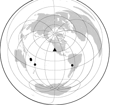
Nearby stations (2 deg radius)

| Station | Name | (Lat, Lon) | Start / End | Elevation |
| POND | XN.POND | (36.01, -120.57) | 2001-06-24 / 2002-10-15 | 735 m |
| Crust2 Type: | T4,Margin /shield transition, East Siberia, 2 km seds. |
| Thickness Estimate: | 63 km |
| Thickness StdDev: | 13 km |
| Vp/Vs Estimate: | 2.10 |
| Vp/Vs StdDev: | 0.22 |
| Vs Estimate: | 3.047 km/s |
| Poisson's Ratio: | 0.35 |
| Peak Value: | 0.03 |
| Assumed Vp: | 6.391 km/s |
| Ps Weight: | 0.33333334 |
| PpPs Weight: | 0.33333334 |
| PsPs Weight: | 0.33333328 |
| Residual Complexity: | 0.904 |
| Nearby stations H: | 41 km +- 20 km |
| (2.0 deg) Vp/Vs: | 1.85 +- 0.22 |
0 with match > 90% ( 0.0 %) and 4 with match > 80% ( 20.0 %) out of 20.
Download stack as xyz text file.
Azimuth Distribution of Events:
Prior Results for this Station
| Study | Thickness | Vp/Vs | Vp | Vs | Poissons Ratio | Extra |
| EARS | 63 km | 2.10 | 6.391 km/s | 3.047 km/s | 0.35 | |
| Crust2.0 | 32 km | 1.79 | 6.391 km/s | 3.572 km/s | 0.27 | T4,Margin /shield transition, East Siberia, 2 km seds. |
| Global Maxima | 63 km | 2.10 | 6.391 km/s | 3.047 km/s | 0.35 | amp=0.030542355 |
| Local Maxima 1 | 36 km | 1.68 | 6.391 km/s | 3.804 km/s | 0.23 | amp=0.028078765 |
| Local Maxima 2 | 44 km | 1.60 | 6.391 km/s | 3.988 km/s | 0.18 | amp=0.021475356 |
| Local Maxima 3 | 34 km | 1.72 | 6.391 km/s | 3.726 km/s | 0.24 | amp=0.015641265 |
| Local Maxima 4 | 62 km | 2.08 | 6.391 km/s | 3.069 km/s | 0.35 | amp=0.012964402 |
| Predicted Arrivals for vertical incidence (zero ray parameter) | |
| Ps | 10.82 SECOND |
| PpPs | 30.54 SECOND |
| PsPs/PpSs | 41.36 SECOND |
Events Processed for this Station
Download zip of receiver functions as SAC
Plot maxima for each earthquake.
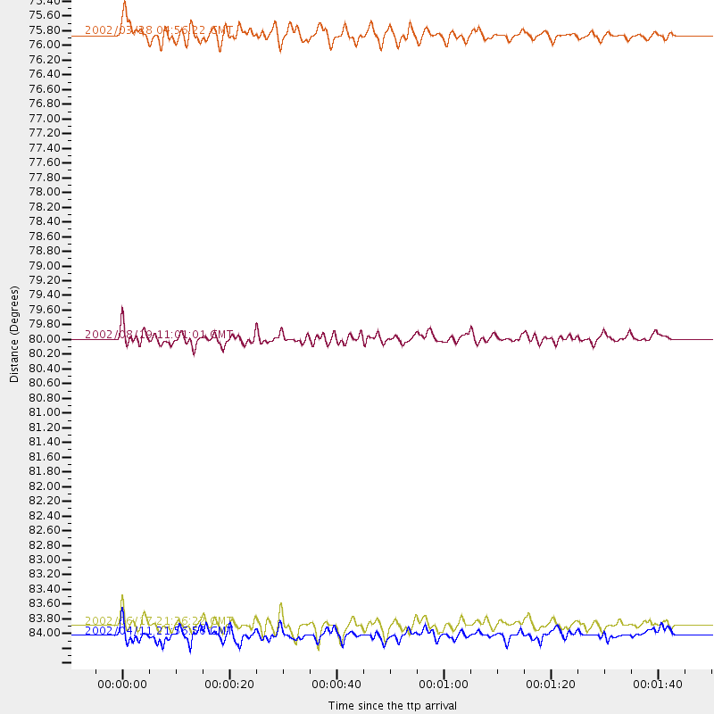
Events Used in the Stack
(4 events)| Radial Match | Distance | Baz | FERegion | Time | Lat/Lon | Depth | Magnitude |
| 87.92919 | 84.2 deg | 247.671 deg | Vanuatu Islands | 2002/04/11 21:56:56 GMT | (-14.4, 167.7) | 10 km | 5.9 MB, 6.2 MS, 6.2 MW, 6.1 MW |
| 87.16468 | 75.7 deg | 130.63 deg | Chile-Bolivia Border Region | 2002/03/28 04:56:22 GMT | (-21.7, -68.3) | 125 km | 6.1 MB, 6.5 MW, 6.5 MW |
| 83.40574 | 80.0 deg | 233.999 deg | Fiji Islands Region | 2002/08/19 11:01:01 GMT | (-21.7, -179.5) | 580 km | 6.7 MB, 7.6 MW, 7.7 ME |
| 80.8643 | 84.0 deg | 249.871 deg | Santa Cruz Islands | 2002/06/17 21:26:22 GMT | (-12.6, 166.4) | 33 km | 6.0 MB, 6.7 MS, 6.7 MW, 6.6 MW |
Losers
(16 events)| Radial Match | Distance | Baz | FERegion | Time | Lat/Lon | Depth | Magnitude | Reason |
| 95.72279 | 97.2 deg | 271.133 deg | Near N Coast Of New Guinea, P.N.G. | 2002/09/08 18:44:23 GMT | (-3.3, 142.9) | 13 km | 6.5 MB, 7.8 MS, 7.6 MW, 7.3 MW | |
| 84.23803 | 77.4 deg | 316.581 deg | Northeastern China | 2002/09/15 08:39:32 GMT | (44.8, 129.9) | 586 km | 5.8 MB, 6.4 MW, 6.4 MW | |
| 80.69777 | 81.1 deg | 138.565 deg | Near Coast Of Central Chile | 2002/06/18 13:56:22 GMT | (-30.8, -71.1) | 54 km | 6.0 MB, 6.6 MW, 6.4 MW | |
| 77.85384 | 82.7 deg | 137.726 deg | San Juan Province, Argentina | 2002/09/24 03:57:22 GMT | (-31.5, -69.2) | 120 km | 6.2 MB, 6.4 MW, 6.3 MW | |
| 73.45597 | 80.1 deg | 233.813 deg | Fiji Islands Region | 2002/08/19 11:45:29 GMT | (-21.9, -179.4) | 600 km | 5.5 MB | |
| 72.85323 | 81.0 deg | 299.564 deg | Southeast Of Honshu, Japan | 2002/08/02 23:11:39 GMT | (29.3, 139.0) | 426 km | 5.5 MB, 6.3 MW, 6.3 MW | |
| 67.0815 | 82.9 deg | 233.812 deg | South Of Fiji Islands | 2002/08/19 11:23:06 GMT | (-23.9, 178.4) | 677 km | 6.1 MB | |
| 64.666626 | 86.4 deg | 242.917 deg | Vanuatu Islands | 2002/08/12 02:59:24 GMT | (-19.5, 169.0) | 112 km | 5.6 MB, 6.0 MW, 5.9 MW | |
| 63.4394 | 82.6 deg | 233.942 deg | South Of Fiji Islands | 2002/08/19 11:03:13 GMT | (-23.6, 178.5) | 650 km | 5.9 MB | |
| 61.712032 | 76.8 deg | 236.195 deg | Fiji Islands Region | 2002/05/04 07:00:48 GMT | (-17.9, -178.7) | 560 km | 5.3 MB, 5.8 MW, 5.7 MW | |
| 58.664837 | 81.2 deg | 234.459 deg | South Of Fiji Islands | 2002/06/30 21:29:36 GMT | (-22.2, 179.2) | 620 km | 5.5 MB, 6.5 MW, 6.4 MW | |
| 56.366745 | 86.2 deg | 243.224 deg | Vanuatu Islands | 2002/05/30 14:41:40 GMT | (-19.1, 169.0) | 158 km | 5.6 MB, 5.6 MW, 5.6 MW | |
| 54.248337 | 78.2 deg | 231.887 deg | Fiji Islands Region | 2002/08/07 04:50:06 GMT | (-21.9, -176.6) | 174 km | 5.4 MB, 5.8 MW, 5.7 MW | |
| 51.179867 | 74.1 deg | 233.214 deg | Tonga Islands | 2002/05/08 05:26:00 GMT | (-17.9, -174.6) | 131 km | 5.4 MB, 6.3 MW, 6.2 MW | |
| 50.28096 | 76.7 deg | 236.19 deg | Fiji Islands Region | 2002/06/16 06:55:13 GMT | (-17.9, -178.7) | 569 km | 5.7 MB, 5.9 MW, 5.9 MW | |
| 46.974773 | 84.0 deg | 248.928 deg | Vanuatu Islands | 2002/06/27 07:16:10 GMT | (-13.3, 167.1) | 187 km | 6.0 MB, 6.1 MW |
