
Station XN POWR - XN.POWR
Network: XN00 - RPI-UW Parkfield Calibration Array
Nearby stations (2 deg radius)
| Station | Name | (Lat, Lon) | Start / End | Elevation |
| POWR | XN.POWR | (36.01, -120.53) | 2001-06-24 / 2002-10-15 | 953 m |
| Crust2 Type: | T4,Margin /shield transition, East Siberia, 2 km seds. |
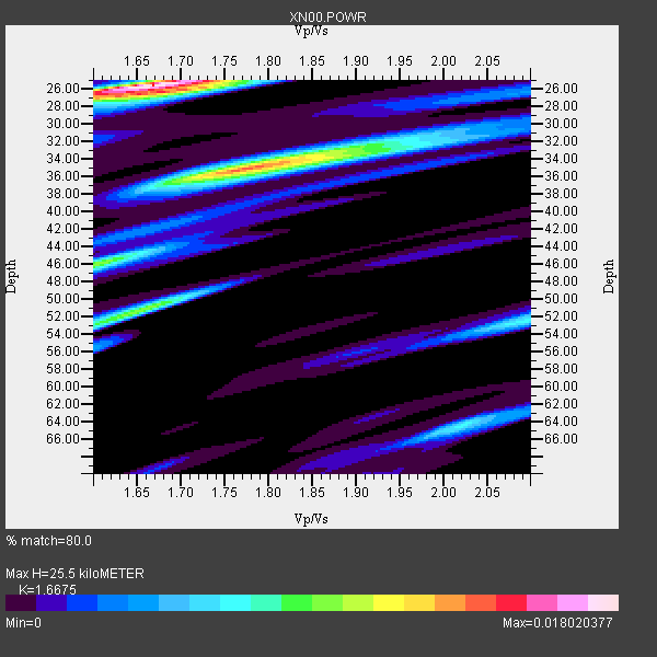
| Thickness Estimate: | 26 km |
| Thickness StdDev: | 9.8 km |
| Vp/Vs Estimate: | 1.67 |
| Vp/Vs StdDev: | 0.09 |
| Vs Estimate: | 3.832 km/s |
| Poisson's Ratio: | 0.22 |
| Peak Value: | 0.02 |
| Assumed Vp: | 6.391 km/s |
| Ps Weight: | 0.33333334 |
| PpPs Weight: | 0.33333334 |
| PsPs Weight: | 0.33333328 |
| Residual Complexity: | 0.790 |
| Nearby stations H: | 30 km +- 4.7 km |
| (2.0 deg) Vp/Vs: | 1.82 +- 0.14 |
0 with match > 90% ( 0.0 %) and 8 with match > 80% ( 34.782608 %) out of 23.
Download stack as xyz text file.
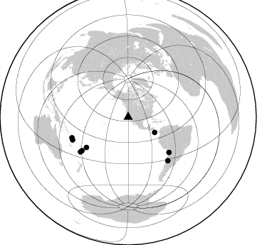
Azimuth Distribution of Events:
Prior Results for this Station
| Study | Thickness | Vp/Vs | Vp | Vs | Poissons Ratio | Extra |
| EARS | 26 km | 1.67 | 6.391 km/s | 3.832 km/s | 0.22 | |
| Crust2.0 | 32 km | 1.79 | 6.391 km/s | 3.572 km/s | 0.27 | T4,Margin /shield transition, East Siberia, 2 km seds. |
| Global Maxima | 26 km | 1.67 | 6.391 km/s | 3.832 km/s | 0.22 | amp=0.018020377 |
| Local Maxima 1 | 35 km | 1.77 | 6.391 km/s | 3.6 km/s | 0.27 | amp=0.013854799 |
| Local Maxima 2 | 51 km | 1.66 | 6.391 km/s | 3.85 km/s | 0.22 | amp=0.009675468 |
| Local Maxima 3 | 46 km | 1.60 | 6.391 km/s | 3.994 km/s | 0.18 | amp=0.009349272 |
| Local Maxima 4 | 52 km | 2.09 | 6.391 km/s | 3.061 km/s | 0.35 | amp=0.0071014934 |
| Predicted Arrivals for vertical incidence (zero ray parameter) | |
| Ps | 2.66 SECOND |
| PpPs | 10.64 SECOND |
| PsPs/PpSs | 13.31 SECOND |
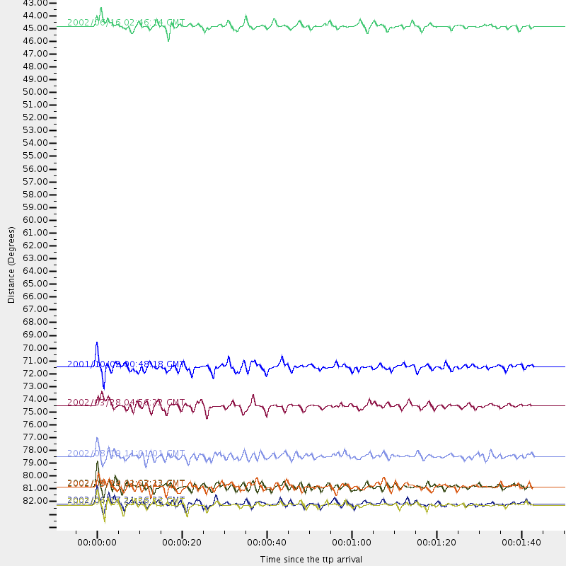
Events Processed for this Station
Download zip of receiver functions as SAC
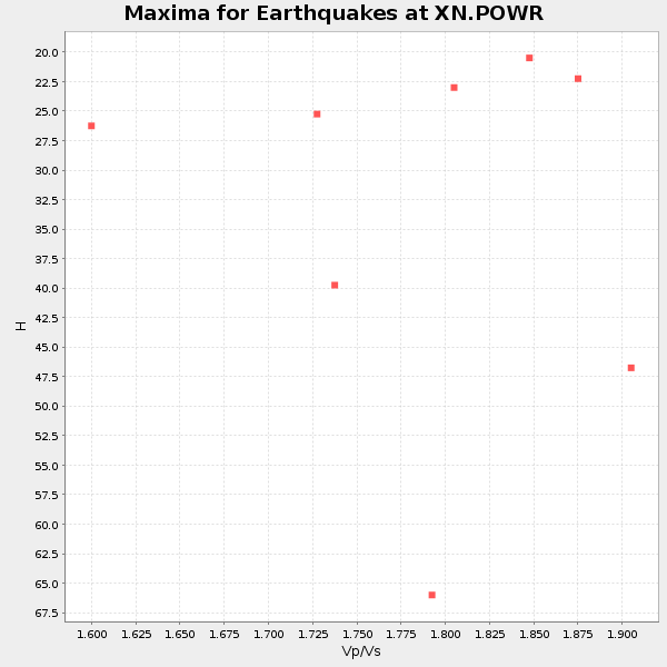
Plot maxima for each earthquake.
Events Used in the Stack
(8 events)| Radial Match | Distance | Baz | FERegion | Time | Lat/Lon | Depth | Magnitude |
| 88.55408 | 84.2 deg | 247.694 deg | Vanuatu Islands | 2002/04/11 21:56:56 GMT | (-14.4, 167.7) | 10 km | 5.9 MB, 6.2 MS, 6.2 MW, 6.1 MW |
| 88.24308 | 42.9 deg | 120.147 deg | Costa Rica | 2002/06/16 02:46:14 GMT | (8.8, -84.0) | 35 km | 5.4 MB, 6.2 MS, 6.4 MW, 6.4 MW |
| 87.39041 | 80.0 deg | 234.024 deg | Fiji Islands Region | 2002/08/19 11:01:01 GMT | (-21.7, -179.5) | 580 km | 6.7 MB, 7.6 MW, 7.7 ME |
| 86.60554 | 75.7 deg | 130.654 deg | Chile-Bolivia Border Region | 2002/03/28 04:56:22 GMT | (-21.7, -68.3) | 125 km | 6.1 MB, 6.5 MW, 6.5 MW |
| 85.01495 | 82.6 deg | 233.967 deg | South Of Fiji Islands | 2002/08/19 11:03:13 GMT | (-23.6, 178.5) | 650 km | 5.9 MB |
| 84.34023 | 72.3 deg | 233.943 deg | Tonga Islands | 2001/10/02 00:48:18 GMT | (-16.2, -173.8) | 107 km | 5.8 MB, 6.2 MW, 6.1 MW |
| 84.14774 | 84.1 deg | 249.894 deg | Santa Cruz Islands | 2002/06/17 21:26:22 GMT | (-12.6, 166.4) | 33 km | 6.0 MB, 6.7 MS, 6.7 MW, 6.6 MW |
| 81.43651 | 82.6 deg | 137.75 deg | San Juan Province, Argentina | 2002/09/24 03:57:22 GMT | (-31.5, -69.2) | 120 km | 6.2 MB, 6.4 MW, 6.3 MW |
Losers
(15 events)| Radial Match | Distance | Baz | FERegion | Time | Lat/Lon | Depth | Magnitude | Reason |
| 83.50086 | 81.0 deg | 138.589 deg | Near Coast Of Central Chile | 2002/06/18 13:56:22 GMT | (-30.8, -71.1) | 54 km | 6.0 MB, 6.6 MW, 6.4 MW | |
| 81.605804 | 77.4 deg | 316.598 deg | Northeastern China | 2002/09/15 08:39:32 GMT | (44.8, 129.9) | 586 km | 5.8 MB, 6.4 MW, 6.4 MW | |
| 76.291405 | 82.0 deg | 134.468 deg | Catamarca Province, Argentina | 2002/05/28 04:04:22 GMT | (-28.9, -66.8) | 22 km | 6.0 MB, 5.7 MS, 6.0 MW, 5.9 MW | |
| 73.59289 | 81.0 deg | 299.584 deg | Southeast Of Honshu, Japan | 2002/08/02 23:11:39 GMT | (29.3, 139.0) | 426 km | 5.5 MB, 6.3 MW, 6.3 MW | |
| 71.553345 | 76.7 deg | 232.647 deg | Fiji Islands Region | 2002/09/07 08:14:19 GMT | (-20.3, -176.0) | 210 km | 5.5 MB, 6.0 MW, 6.0 MW | |
| 69.75204 | 86.5 deg | 242.939 deg | Vanuatu Islands | 2002/08/12 02:59:24 GMT | (-19.5, 169.0) | 112 km | 5.6 MB, 6.0 MW, 5.9 MW | |
| 68.21365 | 76.8 deg | 236.216 deg | Fiji Islands Region | 2002/06/16 06:55:13 GMT | (-17.9, -178.7) | 569 km | 5.7 MB, 5.9 MW, 5.9 MW | |
| 67.37828 | 78.2 deg | 231.913 deg | Fiji Islands Region | 2002/08/07 04:50:06 GMT | (-21.9, -176.6) | 174 km | 5.4 MB, 5.8 MW, 5.7 MW | |
| 65.39824 | 76.8 deg | 236.222 deg | Fiji Islands Region | 2002/05/04 07:00:48 GMT | (-17.9, -178.7) | 560 km | 5.3 MB, 5.8 MW, 5.7 MW | |
| 65.10432 | 82.9 deg | 233.836 deg | South Of Fiji Islands | 2002/08/19 11:23:06 GMT | (-23.9, 178.4) | 677 km | 6.1 MB | |
| 63.72757 | 74.1 deg | 233.242 deg | Tonga Islands | 2002/05/08 05:26:00 GMT | (-17.9, -174.6) | 131 km | 5.4 MB, 6.3 MW, 6.2 MW | |
| 61.165405 | 72.9 deg | 236.207 deg | Tonga Islands | 2002/06/21 14:21:44 GMT | (-15.1, -175.9) | 319 km | 5.7 MB, 5.7 MW, 5.7 MW | |
| 53.52432 | 84.0 deg | 248.952 deg | Vanuatu Islands | 2002/06/27 07:16:10 GMT | (-13.3, 167.1) | 187 km | 6.0 MB, 6.1 MW | |
| 52.68308 | 93.8 deg | 191.004 deg | Pacific-Antarctic Ridge | 2002/07/19 06:43:55 GMT | (-56.6, -140.7) | 10 km | 5.6 MS, 5.1 MB, 6.1 MW, 6.0 MW | |
| 51.69998 | 80.1 deg | 233.838 deg | Fiji Islands Region | 2002/08/19 11:45:29 GMT | (-21.9, -179.4) | 600 km | 5.5 MB |
