
Station XN PRIS - XN.PRIS
Network: XN00 - RPI-UW Parkfield Calibration Array
Nearby stations (2 deg radius)
| Station | Name | (Lat, Lon) | Start / End | Elevation |
| PRIS | XN.PRIS | (35.98, -120.49) | 2001-06-24 / 2002-10-15 | 638 m |
| Crust2 Type: | S1,continental slope, margin, transition 1 km seds. |
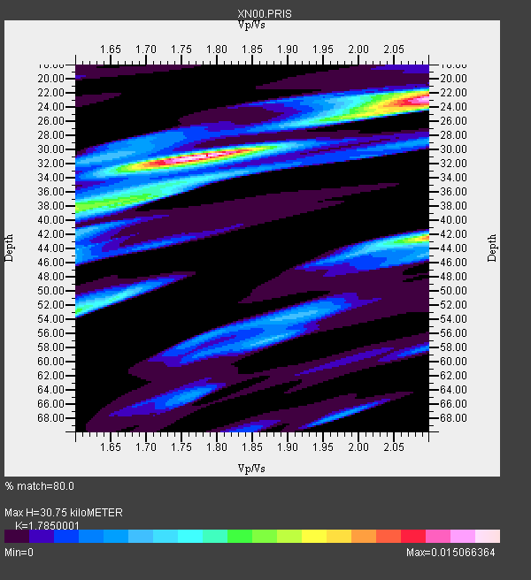
| Thickness Estimate: | 31 km |
| Thickness StdDev: | 13 km |
| Vp/Vs Estimate: | 1.79 |
| Vp/Vs StdDev: | 0.18 |
| Vs Estimate: | 3.464 km/s |
| Poisson's Ratio: | 0.27 |
| Peak Value: | 0.02 |
| Assumed Vp: | 6.183 km/s |
| Ps Weight: | 0.33333334 |
| PpPs Weight: | 0.33333334 |
| PsPs Weight: | 0.33333328 |
| Residual Complexity: | 0.711 |
| Nearby stations H: | 26 km +- 3.7 km |
| (2.0 deg) Vp/Vs: | 2.02 +- 0.15 |
0 with match > 90% ( 0.0 %) and 5 with match > 80% ( 33.333332 %) out of 15.
Download stack as xyz text file.
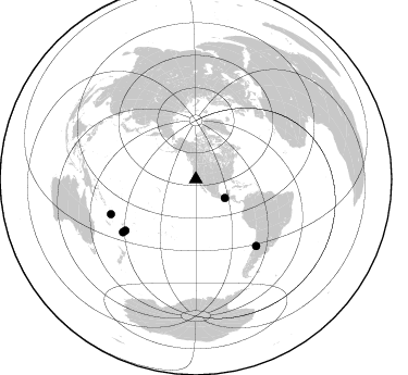
Azimuth Distribution of Events:
Prior Results for this Station
| Study | Thickness | Vp/Vs | Vp | Vs | Poissons Ratio | Extra |
| EARS | 31 km | 1.79 | 6.183 km/s | 3.464 km/s | 0.27 | |
| Crust2.0 | 23 km | 1.81 | 6.183 km/s | 3.422 km/s | 0.28 | S1,continental slope, margin, transition 1 km seds. |
| Global Maxima | 31 km | 1.79 | 6.183 km/s | 3.464 km/s | 0.27 | amp=0.015066364 |
| Local Maxima 1 | 23 km | 2.10 | 6.183 km/s | 2.948 km/s | 0.35 | amp=0.014387705 |
| Local Maxima 2 | 42 km | 2.10 | 6.183 km/s | 2.948 km/s | 0.35 | amp=0.011559047 |
| Local Maxima 3 | 53 km | 1.60 | 6.183 km/s | 3.864 km/s | 0.18 | amp=0.007268898 |
| Local Maxima 4 | 38 km | 1.60 | 6.183 km/s | 3.864 km/s | 0.18 | amp=0.0069461195 |
| Predicted Arrivals for vertical incidence (zero ray parameter) | |
| Ps | 3.90 SECOND |
| PpPs | 13.85 SECOND |
| PsPs/PpSs | 17.76 SECOND |
Events Processed for this Station
Download zip of receiver functions as SAC
Plot maxima for each earthquake.
Events Used in the Stack
(5 events)| Radial Match | Distance | Baz | FERegion | Time | Lat/Lon | Depth | Magnitude |
| 89.17791 | 80.0 deg | 234.058 deg | Fiji Islands Region | 2002/08/19 11:01:01 GMT | (-21.7, -179.5) | 580 km | 6.7 MB, 7.6 MW, 7.7 ME |
| 83.101036 | 31.8 deg | 122.789 deg | Near Coast Of Chiapas, Mexico | 2002/01/16 23:09:52 GMT | (15.5, -93.1) | 80 km | 5.8 MB, 6.4 MW, 6.4 MW |
| 82.16505 | 82.6 deg | 137.777 deg | San Juan Province, Argentina | 2002/09/24 03:57:22 GMT | (-31.5, -69.2) | 120 km | 6.2 MB, 6.4 MW, 6.3 MW |
| 82.036064 | 82.6 deg | 233.999 deg | South Of Fiji Islands | 2002/08/19 11:03:13 GMT | (-23.6, 178.5) | 650 km | 5.9 MB |
| 80.16014 | 84.2 deg | 247.724 deg | Vanuatu Islands | 2002/04/11 21:56:56 GMT | (-14.4, 167.7) | 10 km | 5.9 MB, 6.2 MS, 6.2 MW, 6.1 MW |
Losers
(10 events)| Radial Match | Distance | Baz | FERegion | Time | Lat/Lon | Depth | Magnitude | Reason |
| 80.52363 | 81.0 deg | 138.617 deg | Near Coast Of Central Chile | 2002/06/18 13:56:22 GMT | (-30.8, -71.1) | 54 km | 6.0 MB, 6.6 MW, 6.4 MW | |
| 63.863266 | 78.2 deg | 231.949 deg | Fiji Islands Region | 2002/08/07 04:50:06 GMT | (-21.9, -176.6) | 174 km | 5.4 MB, 5.8 MW, 5.7 MW | |
| 62.45487 | 72.9 deg | 236.247 deg | Tonga Islands | 2002/06/21 14:21:44 GMT | (-15.1, -175.9) | 319 km | 5.7 MB, 5.7 MW, 5.7 MW | |
| 59.989983 | 76.8 deg | 236.253 deg | Fiji Islands Region | 2002/06/16 06:55:13 GMT | (-17.9, -178.7) | 569 km | 5.7 MB, 5.9 MW, 5.9 MW | |
| 59.68076 | 81.1 deg | 299.611 deg | Southeast Of Honshu, Japan | 2002/08/02 23:11:39 GMT | (29.3, 139.0) | 426 km | 5.5 MB, 6.3 MW, 6.3 MW | |
| 57.081104 | 86.9 deg | 254.17 deg | Solomon Islands | 2002/10/03 04:26:06 GMT | (-11.0, 161.4) | 10 km | 5.6 MB, 5.6 MS, 5.9 MW, 5.7 MW | |
| 55.745007 | 84.0 deg | 248.982 deg | Vanuatu Islands | 2002/06/27 07:16:10 GMT | (-13.3, 167.1) | 187 km | 6.0 MB, 6.1 MW | |
| 54.102818 | 76.8 deg | 236.258 deg | Fiji Islands Region | 2002/05/04 07:00:48 GMT | (-17.9, -178.7) | 560 km | 5.3 MB, 5.8 MW, 5.7 MW | |
| 53.8665 | 85.0 deg | 246.948 deg | Vanuatu Islands | 2002/06/10 02:53:47 GMT | (-15.5, 167.5) | 116 km | 5.6 MW, 5.2 MB, 5.6 MW | |
| 48.429028 | 80.1 deg | 233.872 deg | Fiji Islands Region | 2002/08/19 11:45:29 GMT | (-21.9, -179.4) | 600 km | 5.5 MB |
