
Station XO LG19 - LG19 of OIINK Flexarray
Network: XO11 - Ozark Illinois, Indiana and Kentucky ES Flexible Array
Nearby stations (2 deg radius)

| Station | Name | (Lat, Lon) | Start / End | Elevation |
| LG19 | LG19 of OIINK Flexarray | (37.60, -89.05) | 2011-07-19 / 2015-12-31 | 203 m |
| Crust2 Type: | D6,Platform 2 km seds. |
| Thickness Estimate: | 45 km |
| Thickness StdDev: | 10 km |
| Vp/Vs Estimate: | 2.09 |
| Vp/Vs StdDev: | 0.22 |
| Vs Estimate: | 3.087 km/s |
| Poisson's Ratio: | 0.35 |
| Peak Value: | 0.02 |
| Assumed Vp: | 6.444 km/s |
| Ps Weight: | 0.33333334 |
| PpPs Weight: | 0.33333334 |
| PsPs Weight: | 0.33333328 |
| Residual Complexity: | 0.719 |
| Nearby stations H: | +- |
| (2.0 deg) Vp/Vs: | +- |
2 with match > 90% ( 15.384615 %) and 6 with match > 80% ( 46.153847 %) out of 13.
Download stack as xyz text file.
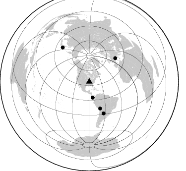
Azimuth Distribution of Events:
Prior Results for this Station
| Study | Thickness | Vp/Vs | Vp | Vs | Poissons Ratio | Extra |
| EARS | 45 km | 2.09 | 6.444 km/s | 3.087 km/s | 0.35 | |
| Crust2.0 | 41 km | 1.78 | 6.444 km/s | 3.629 km/s | 0.27 | D6,Platform 2 km seds. |
| Global Maxima | 45 km | 2.09 | 6.444 km/s | 3.087 km/s | 0.35 | amp=0.023586914 |
| Local Maxima 1 | 44 km | 2.09 | 6.444 km/s | 3.087 km/s | 0.35 | amp=0.012537744 |
| Local Maxima 2 | 27 km | 1.66 | 6.444 km/s | 3.888 km/s | 0.21 | amp=0.011404524 |
| Local Maxima 3 | 58 km | 1.61 | 6.444 km/s | 4.009 km/s | 0.18 | amp=0.0113815665 |
| Local Maxima 4 | 65 km | 1.77 | 6.444 km/s | 3.646 km/s | 0.26 | amp=0.0112640355 |
| Predicted Arrivals for vertical incidence (zero ray parameter) | |
| Ps | 7.59 SECOND |
| PpPs | 21.56 SECOND |
| PsPs/PpSs | 29.16 SECOND |
Events Processed for this Station
Download zip of receiver functions as SAC
Plot maxima for each earthquake.
Events Used in the Stack
(6 events)| Radial Match | Distance | Baz | FERegion | Time | Lat/Lon | Depth | Magnitude |
| 99.26255 | 57.9 deg | 157.998 deg | Peru-Bolivia Border Region | 2012/05/14 10:00:40 GMT | (-17.7, -69.6) | 106 km | 6.4 MB, 6.2 MW, 6.2 MW |
| 98.382835 | 87.6 deg | 322.132 deg | Off East Coast Of Honshu, Japan | 2012/03/14 09:08:35 GMT | (40.9, 144.9) | 12 km | 6.7 MB, 6.9 MS, 6.9 MW, 7.0 MW |
| 88.13772 | 32.7 deg | 168.102 deg | South Of Panama | 2012/06/04 00:45:15 GMT | (5.3, -82.6) | 7.0 km | 5.9 MB, 5.9 MS, 6.3 MW, 6.2 MW |
| 85.90269 | 69.7 deg | 155.64 deg | Santiago Del Estero Prov., Arg. | 2012/05/28 05:07:23 GMT | (-28.0, -63.1) | 587 km | 6.0 MB, 6.7 MW, 6.8 MW |
| 81.99342 | 32.5 deg | 167.92 deg | South Of Panama | 2012/06/04 03:15:24 GMT | (5.5, -82.6) | 7.0 km | 5.8 MB, 5.8 MS, 6.3 MW, 6.1 MW |
| 81.84327 | 70.9 deg | 47.827 deg | Northern Italy | 2012/05/29 07:00:03 GMT | (44.9, 11.1) | 10 km | 5.9 MB, 5.8 MS, 5.8 MW, 5.8 MW |
Losers
(7 events)| Radial Match | Distance | Baz | FERegion | Time | Lat/Lon | Depth | Magnitude | Reason |
| 76.55477 | 65.3 deg | 161.66 deg | Near Coast Of Northern Chile | 2012/05/19 08:35:10 GMT | (-25.7, -70.6) | 28 km | 5.7 MB, 5.5 MS, 5.8 MW, 5.9 MW | |
| 75.42581 | 66.7 deg | 321.45 deg | Komandorskiye Ostrova Region | 2012/05/29 02:40:53 GMT | (54.4, 168.9) | 10 km | 5.5 MS, 5.4 MB, 5.6 MW, 5.6 MW | |
| 74.75634 | 64.0 deg | 153.63 deg | Salta Province, Argentina | 2012/06/02 07:52:53 GMT | (-22.1, -63.6) | 527 km | 5.8 MB, 5.9 MW, 6.0 MW | |
| 73.23303 | 82.4 deg | 173.63 deg | Off Coast Of Southern Chile | 2012/05/18 02:00:39 GMT | (-44.8, -80.2) | 10 km | 5.5 MB, 5.7 MS, 6.3 MW, 6.3 MW | |
| 65.59706 | 88.6 deg | 324.094 deg | Hokkaido, Japan Region | 2012/05/23 15:02:25 GMT | (41.3, 142.1) | 46 km | 6.2 MB, 5.5 MS, 5.9 MW, 6.0 MW | |
| 58.730827 | 70.8 deg | 47.827 deg | Northern Italy | 2012/05/29 10:55:57 GMT | (44.9, 11.0) | 6.8 km | 5.6 MB, 5.3 MS, 5.5 MW, 5.4 MW | |
| 56.524914 | 79.0 deg | 44.169 deg | Bulgaria | 2012/05/22 00:00:32 GMT | (42.6, 23.0) | 10 km | 5.7 MB, 5.3 MS, 5.6 MW, 5.5 MW |
